Online Aerial Scouting
Elk
Just wanted to share some info I found now that its time to start doing some aerial scouting.
I like to to use a mix of aerial views - GE, Flashearth, and Bing Maps [Bird's Eye View] If you use Bing Birds Eye View, be sure to look at a spot from ALL directions
A few years ago I was researching a unit for elk hunting.
As I was looking at different water holes, I noticed this one tree that looked like it had a few branches cut out for a tree stand.

I entered the coordinates into my GPS and when I went to scout, I walked up to this tree

So I hung a tree stand over that water hole.

I never shot an elk from that tree stand, but I did see plenty of elk
Here is a pic on an elk I saw from that tree stand

That's cool,we use google earth and even found elk
I drew a special tag in New Mexico in 2014. I bought a topo of the unit and studied all features while alternating between the map and google earth. The map was pretty much marked up by time I went on the hunt. I was fortunate to kill a big bull on a waterhole that I noted as looking promising. The info I would like to share is, the google earth image was a couple of years old when I studied the area. This waterhole had water in it, from my studies I wrote on the map, things like "this water hole appears dry", "this one looks like promising". After the hunt I went back on google earth to look at the images knowing I killed a nice bull there. They had an updated image taken in June of that year. The waterhole was dry, had I did my aerial map study after June, I may have never checked that waterhole out and maybe would've not punched my tag. Before my hunt they had a rainy spell which refilled this waterhole. So keep this in mind when looking at google earth images, if the topo map shows water, google earth appears dry, or vice versa, it depends on the precipitation prior to the hunt what state the waterhole will be in, on waterholes that are filled by runoff.
Good luck hunting, unless your hunting in my vicinity, then just chase them my way!
Always a good staring point, one more tool in the bag of a well rounded Elk hunter, but nothing replaces boots on the ground... JMHO
My main area has a date in mid-September on the time slider. I zoomed in and logged the locations of all the camps and parked vehicles. Hunters are creatures of habit, even unsuccessful ones, and those camp and parking locations still hold true today.
Elkman, great advice. In my new area, 90% of the areas I'd pre-scouted were eliminated with boots on the ground, and some of my best spots have been found during season based on where other guys aren't hunting.
But I have found some great little honeyholes by using a combination of the DIY maps and the StartMyHunt maps, both Bowsite sponsors. I called-in and missed a 330 class bull the first time I went into one of them to check it out. Last year I almost killed a 360-class bull in another one I'd always driven past before.
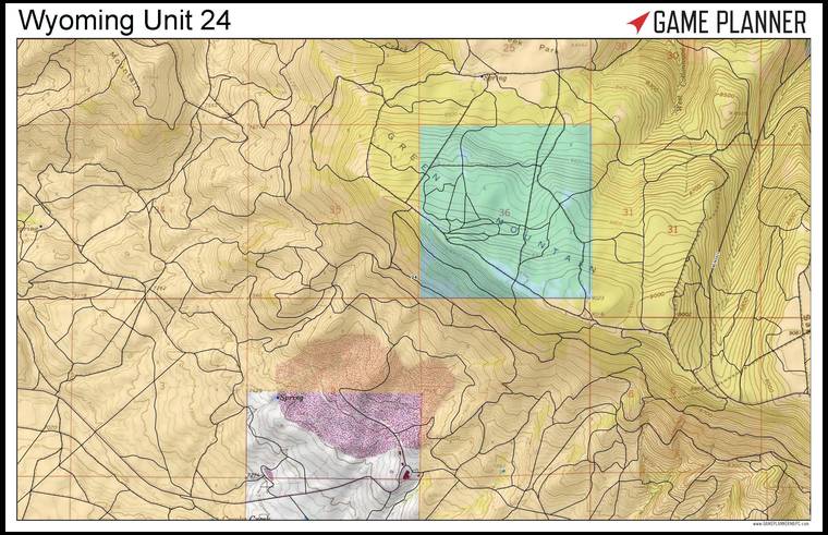
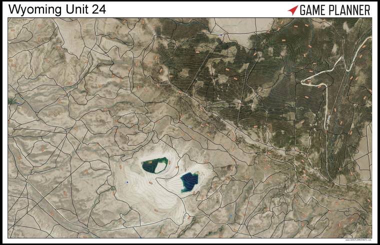
Lou I recently started using Game Planner maps. Have you checked that out? It's free. You can pay for a premium service where you have additional features like harvest stats etc but the free version is good enough. Here's a link.... pick a state and zoom in. Then pick the base maps folder to the left and fade the different layers in and out. I use the aerial layer and then brighten the contours to where I want them over the aerial images. The images are very clear. There are lots of other layers too. I like it.
Heh, Heh! Thanks for that! Another tool in the toolbox. :)
Nice, lots of info, print your own maps, and free! Pretty much everything you could ask for! Thanks Mule Power!
Oh man! Aerials with topo lines!!! I'm hooked!
You can do aerials with topo lines on Google Earth.
Holy smokes, you can transition to the Bing Birds eye view from Game Planner Maps!!
Tberg you sound like me the day I discovered it. haha. I was playing with it for hours. I figured you guys would like that.
I like adding the imagery topo base layer to the aerial imagery so that I can see blue lines for water which really help define the bottoms. It also adds the contours along with elevation numbers on the aerials which makes a heck of an "aerial map".
Be patient though... the owner Ed is still tweeking things. He's a great guy. If you have an issue he's probably working on it. Plus he is at the mercy of the USGS system and they have sent him emails apologizing for errors on their end.
All in all though I think it's a hell of a tool. I love being able to fade the different layers right to where I want them. He will print your custom maps on the waterproof material AND 2 sided. Nice!
I found that adding contours on to Google Earth requires more patence than I have. lol
Been playing around with Game Planner's mapping system for a month or so.. I think it is well worth everyone look in to them. They can build you some very good maps to ur specs.. I will be using them when I know 100% what I'm doing this fall.. The owner name is Ed Vergin, I called to ask a question and he was of great help. He really spent a lot of time explaining the system to me.
I looked a a lot of other map systems and think Game Planner is the best all in one I've seen.
Ed
I like many of the Game Planner features but I did notice I get much better aerial closeups with CalTopo. I get a lot of blur when trying closeups with Birdseye. Makes me wonder if I am not doing something right. cnelk, how did you get such good tree detail in above picture. What software did you use for that. Even my Caltopo doesn't come close to that detail.
Its been my experience that aerial quality can vary greatly from location to location. The advantage the Game Planner system seems to have is convenience. The aerial, topo, and all the other layers are all in one place, and its free! Not to mention all the states available and you can print your own maps!! Tough to beat in my opinion.
I might need to get one of those big printers!