Scouting for CO Elk--new Bowsite Sponsor
Elk
Hi, my name is Mike, and I am a new sponsor to Bowsite. Having hunted elk in CO for over 35 years now, I wanted to combine my backcountry experience with my technical knowledge to find a better way to scout out elk. What I have come up with are my ElkTracker Maps. My ElkTracker maps show all of the following for USFS Lands which make them unique and something you will not find anywhere else all on one map— Elk Scouting Hot Spots—over 7,000 (All of these require some boots on the ground and some work). Elk Security Habitat—Millions of acres Elk Prime Forage Areas—Lots, Lots, Lots Roads and Trails Status--Based upon the 2015 MVUM road maps Land Ownership (Lands Open to Hunting)—Based on the 2013 status Colorado Parks and Wildlife Elk Seasonal Range Data (Summer, Winter, and Migration Routes) All maps are fully customizable to the area you want to hunt based upon a center-point coordinate or familiar landmark. Each map can also be made at any scale you choose. That is why my service is different. You get quality elk habitat, centered on your choice of landmark, with all of the above features added. Please read my testimonial page first-- http://startmyhunt.com/testimonials/
Thanks for the link Mike. What is the price range for a given unit?
Hi TrophyHill. My printed maps go for $35, my GMU report is $30, and my digital elk hunting hot spots (uploadable to your GPS or Google Earth Pro) are $30. Please keep the questions coming.
My Apologies, but re-posting so that the post is easier to read. I am new to this forum stuff but will get the hang of it soon.
Hi, my name is Mike, and I am a new sponsor to Bowsite. Having hunted elk in CO for over 35 years now, I wanted to combine my backcountry experience with my technical knowledge to find a better way to scout out elk. What I have come up with are my ElkTracker Maps.
My ElkTracker maps show all of the following for USFS Lands which make them unique and something you will not find anywhere else all on one map—
Elk Scouting Hot Spots—over 7,000 (All of these require some boots on the ground and some work).
Elk Security Habitat—Millions of acres
Elk Prime Forage Areas—Lots, Lots, Lots
Roads and Trails Status--Based upon the 2015 MVUM road maps
Land Ownership (Lands Open to Hunting)—Based on the 2013 status
Colorado Parks and Wildlife Elk Seasonal Range Data (Summer, Winter, and Migration Routes)
All maps are fully customizable to the area you want to hunt based upon a center-point coordinate or familiar landmark. Each map can also be made at any scale you choose. That is why my service is different. You get quality elk habitat, centered on your choice of landmark, with all of the above features added. Please read my testimonial page first--
http://startmyhunt.com/testimonials/
Good maps; especially for NR's who have limited scouting time.
BP
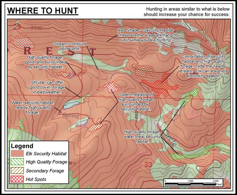
I've checked out these maps for some areas I've hunted and scouted for over 40 years. The information is extremely accurate. The only thing missing are labels saying "Lou's honeyhole" on a couple of them. :)
Someone who doesn't know anything about an area can put the pieces of the puzzle together, matching the security cover with forage, and with a little imagination can figure out where the elk will bed, where they'll feed and the topographical route they'll travel transition.
The migration routes are extremely accurate. The local WCO and Sheriff muzzleloader hunt exactly on one of the arrows on Mike's maps. They just sit there and kill elk every year.
Great tools, well worth the money.
How much is the map that takes me to Lou's Honeyhole?
I think he's going to have a lottery drawing for one copy of that map. Sort of like a Governor's tag...
When I saw the migration arrow going right down the exact draw my friends sit on either side of every year, I just started laughing.
I was looking on your site and trying to figure out what I go to to get a map like the one you show above. I saw the customized map button but wasn't sure if that was it when all it said was to call you.
Truckie, you can either use this link to go directly to the products page-- http://startmyhunt.com/purchase-maps/ or you can click on the 'Elk Hunting Maps' tab in yellow along the top.
Thanks Mike. Looking at some of the examples, I am impressed. Would you consider offering a bowsite discount or a discount for purchasing multiple maps? I'm sure others here are interested as well.
Hi Aaron, I will be offering a 20% discount on the entire order for all Bowsite users starting on Monday. The promotion will run for a week and may be extended based on interest. I just need to have my website programmer get this setup, so keep checking back. Thanks.
Thank you Mike. I will be placing an order for sure. These will go well with some other maps I have.
I am definitely interested. A friend and i are headed for our first DYI elk hunt this September in Southern CO and could use any help we can get.
Trying to remember what it was like to hunt before everything got so technical and hunters had to figure things out themselves. Before internet, cell phones etc.. the good ol day's . Seems like a long time ago.
Now you need to add hunting pressure to the maps. Add where hunters usually camp, their travel routes and hunting areas.
Birdman, I hear you. Back before there were compound bows, carbon and aluminum arrows, topo maps, synthetic clothes, freeze dried food, Goretex, cameras, tree stands, pop up blinds, internal frame packs, backpack stoves, internal combustion engines. Those were truly the "Good old days".
Funny, but with all this technology, the elk archery success rates aren't increasing relative to the elk population metrics. In fact, the success rates are fairly level year over year. Wonder why that is?
Birdman, I could not agree with you more. It still takes a lot of boot leather to be successful and most hunters are not willing to go that extra mile. You still need to have the basics in place before you step out of camp. I am just trying to give the guys who do not have a lot of extra time to scout out their areas a small advantage. Even with my maps, you will still need to work your tail off to get to one of the hot spots on my maps and even harder to pack out your elk.
Aspen Ghost, that is an excellent idea. I have actually been working with the CPW to figure out where guide/outfitter camps are located so that I can add them to my maps.
I think it's a great idea, I've had a similar idea. When you spend a lot of time with elk and in the mountains you can see the trends. I've marked completely new spots in a new area drove hours.. hiked in an hour and there was a herd of elk bedded on my gps point I picked off of Google earth and topos. It can be done especially when combined with some on boot time.
I see it enabling hunters to be able to hunt different terrain/units and still be successful. You can spend lots of time scouting but don't get boots on the ground it many units once season is actually on. I like hunting the same areas every year but having a foot up in new places and terrain would be fun. It might even help hunter distribution.
Nothing against your maps or you start my hunt , It is what it is these days, more hunting pressure, technology , gadgets , etc. Good point Jaquomo, hunter success rates seem to stay the same every year, hmmm, I know why it is in Montana, because they really have no clue of how many elk are actually taken because not everyone that buys a tag is included in their survey. Sounds like Montana and other states are just playing the averages.
Hunter success rates stay the same, sure.
But there are some good things about gadgets.
1. People are having fun. (You're not anti-fun, are you, Lou?)
2. More people are buying tags, supporting wildlife management.
I'm a sucker for maps. I see something like this, and even though I don't hunt in Colorado, I want to purchase the maps, just to sit and look at them. Maybe I have a problem.
I'm a map and scouting freak too, spend way too much time poring over them, then hiking in to check it out. No amount of technology can substitute for boots on the ground.
Two things- hunting pressure trumps everything else. These maps show the habitat variations within the topo, but if a group of eager nimrods are rooting around in the adjacent bedding areas, the game changes.
And these maps could show where an elk is standing at any moment and 90% of bowhunters would still screw it up.
I am now offering a promotional 20% discount on all orders over $120. This is a one time only event and will expire May 3rd at Midnight. I will not be offering discounts in the future. To receive your discount for qualifying orders, enter "bowsite" in the field at the link in this post and then press "Apply Coupon". The field will look like the image.
Forgot to mention that the link in my previous post will appear during the checkout process after you have selected your products.
Almost making me interested in trying a CO OTC hunt. What is a typical cost range to get both the small-scale printed GMU map and the larger-scale pdf maps within that GMU? Do your maps show all trailheads, and whether those are 2wd or 4wd accessible? Finally, can I get GMU maps with grids based on UTM, not lat/long (I like squares better), and can I get the GMU maps printed with a waterproof finish?
Williamtell, will respond in a PM.
Start - Do you mind answering those questions by williamtell? They are all great questions.
Cost for printed maps--$35.
PDFs written to DVD--$35-$80.
Scale of map does not matter concerning price.
My maps show trail heads as accurately as the agencies portray the data. Some of the district offices are better than others at keeping up to date. The roads are broken out by level of access; i.e. closed roads, 4x4, and 2wd.
All the maps have both a UTM grid and the Lat/Long grids. At this time I do not have a waterproof plotter, so I do not offer a waterproof version. That will be my next big purchase.
For the technically savvy, I also make the hot spots available as digital files that can be imported into Google Earth Pro (which is free now) where you can overlay the hot spots in Google and print our your maps of choice. The files are available by GMU.
I was interested in purchasing a map. Am I reading it right that on Saturday you were offering a 20% discount on your entire order starting on Monday and then on Sunday you changed it to a 20% discount only on orders over $120 starting Sunday? Was the advertised discount changed? Unfortunately I wasn't looking to buy $120 in maps. Good luck with your new venture.
Best of luck Mike
I now declare the first meeting of Cartophiles Anonymous open...
'My name is Kenneth and I love maps way too much...'
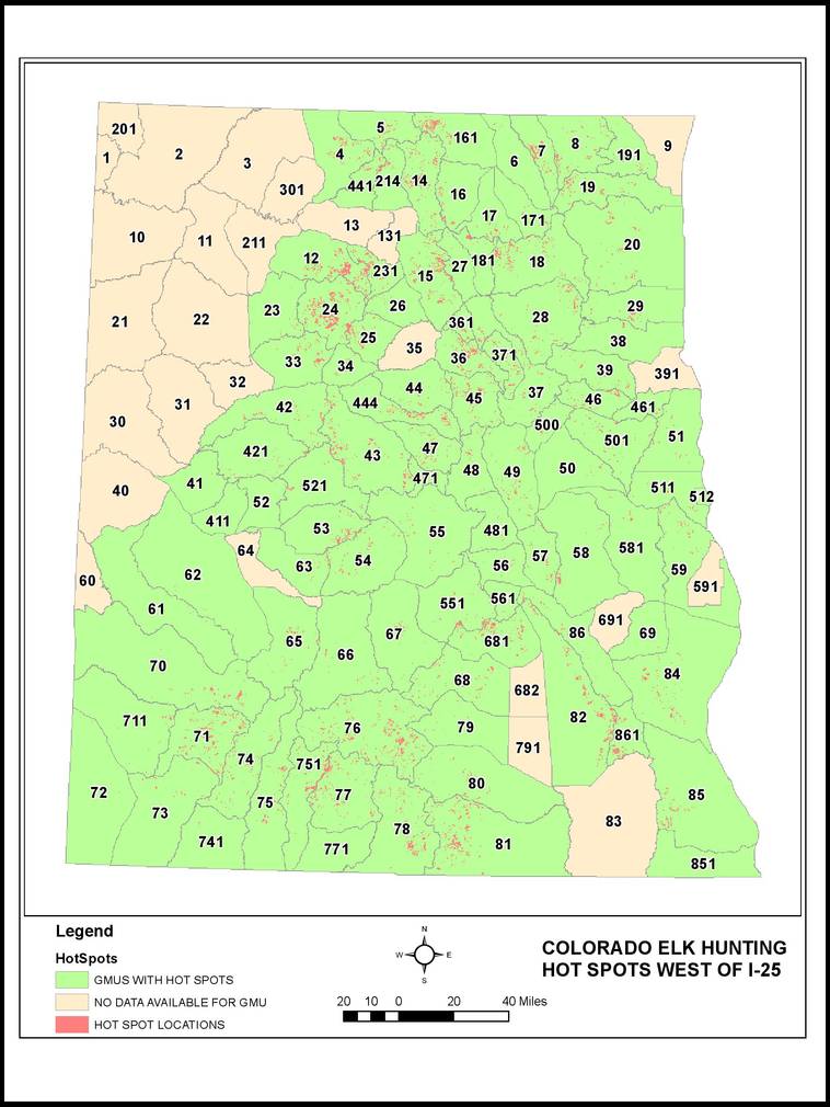
So if I can go to Colorado Wildlife & Parks website and see just about the same information for free (which I have done on numerous occasions for numerous hunts) why would anyone pay over $100 for essentially the same info?
Good question and glad you asked. While it is true you can find the elk seasonal ranges and land ownership on the the CPW page for free, and I do show these features on my maps as a bonus, you will be missing out on the main feature I offer that is not available anywhere else. CPW does not show you elk security habitat, prime forage areas, and most importantly elk scouting/hunting hot spots. You also get the USFS road status on my maps based upon their 2015 MVUM maps. Please read just the first two paragraphs on my home page (click on the link) for a more thorough explanation and then explore the rest of my site if you are still interested.
CrestedButte, to follow up on my response, please scroll to the top of this thread and review the example of the detail found in my maps. This type of detail is not available on the CPW website or on any other map at any price.
Agreed. I do like how you overlay information and can customize to someone's request. Thanks.
Three days left to receive the discount.
Really like the digital hot spots feature and will be using it in the future. What other digital information (shape files, layers or KMZ files) do you make available for purchase to use in ESRI or Google Map?
Thanks for the cool service and for being a sponsor!
Andy
Andy,
Thanks for the interest. I use ESRI software for all my products, so shape files and KMZ products are available. PM sent for more info.
There goes everybodys hard earned honey holes for 35 bucks.
AdventureWriter, the only way I can respond to this is to point out the fact that the number of people hunting for all species is dropping significantly. I am just trying to help keep this tradition alive and make hunting for elk not such a daunting task for those who have not found their honey hole.
Bow hunting is not waning in Colorado... I found all my spots with boot leather...a heavy pack and a folded up topo and determination.... too many people are looking for the easy way... And I have found that people that can't find elk on their own are the same ones that hunt the timber in shifting winds and blow out country as they hike around looking cool in all their new gear.
But now I will politely bow out...good luck with your venture
I cannot disagree with your premise that there is not a substitute for hard work and getting to know the patterns that elk follow within an area. Even with my maps, you still need to hike into these areas with all your gear and if you are successful, have a heavier hike out.
Adventurewriters post reminded me of Mayweather last night.
Dance around and make a jab here and there
I agree writer, too many people are looking for the easy way these days, not just in elk hunting but in all facets of life, it is a shame...
That being said, you can't fault the guy for recognizing a market and developing a product...
best of luck to you start, hope you don't have any of my hot spots identified on your map...
Most everything we use today is a tool which aids our hunting. My compound is an improvement over a stick bow. Carbon arrows are an improvement over wood. A compass is a tool which I still use, but I use my GPS w/landowner owner chip more.
7.5 minute maps have their place, and I just ordered some of Mike's maps. Thank you.
None of these tools take away from the thrill of the flight of my arrow.
Last few hours to receive the discount. Enter bowsite in the coupon code when completing the purchase process.
Cnelk, hoot, and Z Barebow, thanks for the support. I was warned by Charlie that I would get posts like this once I became a sponsor. The way I see it is unless you are hunting in a loin cloth with a sturdy stick, some buffalo twine, and are using obsidian for your points, you are using technology to enhance your hunt. Embrace what you have the opportunity to use and enjoy the hunt.
Interesting idea. I can't help but think you're hot spots will become the good landmarks for places to avoid because all the guys with your maps will be there.
That's "your" not "you're".
Bump for great customer service, mike emailed me tonight to confirm I purchased the correct product before printing after I ordered something different from what we talked about on the phone. He also spent 20 minutes on the phone explaining the differences in his products to me so I got the correct one. A conversation that to him must have sounded like explaining to a five year old what a map was and how to use it...
Also to adventurwriter I understand your frustration. I think this product will be a great tool to help scout out good locations but by no means be a substitute for boots on the ground. I went up Monday Tuesday to scout areas and that helped me choose a map that I will use to scout more 4 or 5 more times this summer. I was given a great tip by a fellow bowsiter, combining that with the little experience I have, reading countless books, hiking and scouting, lots of range time, and some good maps I just might get lucky but it is by no means the only piece to the puzzle.
"Also to Adventurewriter I understand your frustration"
I don't. His posts added nothing to the thread that was constructive. It's not like someone put a tracking device on him and others during elk season last year and have not marked them on maps to be sold. Elk will still be where elk want to be. The overall features of the maps are what is appealing.
I always remember that if the Good Lord hadn't meant us to develop technology, He wouldn't have granted us the wit and insight to do so.
Best of luck Start; as a non-resident of any elk state [by a factor of several thousand miles...] any intel alongside boots on ground, which can assist my development as an elk hunter is to be welcomed
Truckie; please let us know how your season goes...
Good luck and good hunting
Just rec'd my maps. They are awesome. I had existing knowledge of the area, but these maps opened my eyes to new targets worth exploring within reach of my exising zone.
It also showed me travel lanes, which will help me understand where the elk I hear in the woods may be headed.
I'm a map junkie. I buy every map for my area (I have 4 for this area, plus GE) and startmyhunt maps really enlightened me more than the others. I would not recommend to use any map exclusively, as I learn something new (and confirm items) with each new map. Individually, most maps are good. But when you start combining maps you see a much deeper picture of the area. Of all my maps, this startmyhunt really does get one started. It helps pinpoint where the boots should start hitting the ground.
Also, I emailed Mike a few questions, and he actually called me and educated me on the map - helping me understand the area even more!
Great map, excellent customer service.
Anxious to go for a hike!
I agree that maps should be banned. If you can't find your way to Colorado the way the pioneers did, then you're just taking shortcuts.
This generation has it far to easy. When I was a boy, we couldn't afford paper, and we killed elk every year.
John, I appreciate your opinion. However, I have to ask, are you implying that Lewis and Clark did not have maps? What about Columbus? Or Ghengis Khan? They all had a rough idea of where they were going, and they had maps to help guide them to their destination. Sure, they improved upon the originals, but at least they had a starting point.
Point is, and I believe Confucius said this--"You need to know where you are going before you get there." Maps are a great tool to help someone who is not familiar with an area get their bearings and then decide which direction to go after studying the maps.
Mike - I think John is being facetious.
Aaron, you are probably right. I wanted to say that I walked over two miles uphill through two feet of snow both ways to school barefoot.
John, let me know if I was wrong. Good dialogue.
John, I have been informed by a few good gents that you were just being "facetious" as Aaron said. I like that character in a person. You are welcome to hunt with me any time if you make it down to CO.
Uh, oh.
Sometimes dry humor goes over poorly on the interweb.
Bou Bound ... please, show me how it's done. You are, after all, the king of dry.
Don't worry John H; I'm British... we do dry humour as standard ;)
And as for fellow cartoholics, the Bowsite Chapter of Cartoholics Anonymous is open and ready to share...'One Sheet at a Time', as it says in the Big Atlas
I just received my area map from Mike at Start my Hunt. Very high quality map and informative. I had at over 10 different "hot spots" on his small scale Stealth Map. Some of them I knew about, some I found last year and some I had completely overlooked. Mike was spot on using the coordinates I gave him and captured the area I wanted. I will be obtaining more maps of the unit in some different areas as I believe these maps are a great tool. Mike even sent me emails and gave me status updates on my order including the fact that the first map came off of his plotter in less than desirable condition so he gave me that one for no cost. Excellent customer service and high quality maps.
Thanks Mike!