
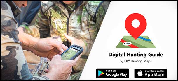

If you want to try it free go to DIYHuntingMaps.com/maps and sign up for a free account. You can then go download the free App from Google Play or iTunes Store:
Click Here for Android Click Here for iOS
Here is a bit more about the App:
Features of The App
If you weren't aware, your phone's GPS works whether you have Cell Service or Not. We've made it easier than ever to pre-download areas you want Offline. Marking Waypoints can now include descriptions and full names with the use of the keyboard you're used too. Not to mention you can Sync your Waypoints to our cloud and get access to them on the online map server. This means you can print maps with your waypoints. Here are a few more features.- GPS Location and Tracking
- Waypoint Management
- Create Waypoint From Coordinates
- High Resolution 20 Ft Topographic Maps
- Access to Hybrid and Satellite Imagery when Online
- Information Like Speed, Elevation and Location
- Simple Double Taps to get Distance or Mark Waypoints
- Access to Legend to Help You Better Access Public Lands
- Unlimited Printable Maps from the Online Server with Waypoints
- It's a simple easy to use Platform
If you have any questions about it, just ask. I'll post some screenshots as well.


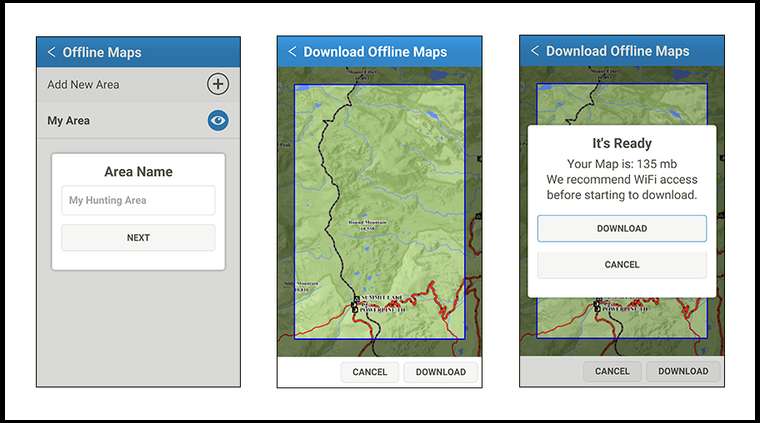

With our app, there is no trying to figure out which tiles you need. Just zoom/pan/pinch and get all the area you need inside of the box and we'll make a custom download for you. After the server is ready, it'll tell you how big the file is and let you download it. It's that simple. Everything inside the box will be downloaded at all zoom levels. You'll never even know whether you're running through the internet or from your device. There is no loss of quality in offline mode.
You just create an account, then download the App.
Inside the app, you go to Offline Maps > Add New Area
You make a name for it, zoom into the area you want and hit download. It'll tell you how big the download will be. If it looks good, you hit download and the app will download and extract the tiles. Depending on how big the area you want is. It could take anywhere from 20 seconds, to a few minutes. My entire hunting area was 140 mb and took about 50 seconds to download.
Once you have Offline Areas, the app will automatically switch from the server or from your installed tiles based on reception. It's really simple.
1) Is the satellite imagery from google maps or some other source? (I find google maps to be superior to other sources)
2) Can you mark waypoints with pictures inside the data? So ie: I have a waypoint and I click on the pic I used to see what was there? ex) a nice scrape in the middle of the bush I click on the waypoint and see the pic of a still steaming scrape :)
3) Are you paying for satellite imagery downloads, topo downloads, nothing or both or other?
1) The satellite imagery is from the USGS NAIP program. Although Google is superior, they also will not let you pre-tile and download their tiles no matter what you pay. I am using USGS served from my server because I plan to incorporate Offline Satellite in the near future. The only way to do this is to serve the imagery myself.
2) That is currently not a feature, although I am familiar with the idea. It's on my future features lists. The app is still a work in process, but just like everything else, I find it better to evolve as I get feedback.
3) You're paying to even access the app. The main feature is the Topo maps though. These aren't ripped off free topo maps that every other company uses. These are high detailed, accurate maps made by myself (i.e. DIY Hunting Maps). All our topo maps are custom made and data vetted for accuracy. It's the only place you're going to find Closed and Decommissioned Roads inside the National Forest, We have all the trailheads, campgrounds, bathrooms, and other POI's, you have all public land boundaries, trails are broken out by designated use (i.e. atv, motorcycle, pack-saddle, hiking, etc), 20 ft topolines displayed over a shaded relief, county and BLM roads marked and a bunch of other things.
It's the same data and symbology I use in our Paper Maps and GPS chips. It's just accessed through the app that lets you use your phone identical to your GPS (well not identical if you can picture waypoints currently :)). The subscription then lets you go online and view the same information along with the ability to print unlimited high resolution maps from your home printer.
Hope that answers your questions.
Jordan
I'm working on the "Tracking" feature as we speak. It'll show a bread crumb trail of where you've been as well as daily stats for distance. I'm not sure on that release, but it shouldn't be too much longer. Right now it'll just show your current location as well as move the map as you move.
Yes it does show private property boundaries. Anything White is private, anything in color is some sort of public lands. In the menu there is a full Legend that will give you a description for what each color means.
Jordan
Jordan
I definitely plan on checking out the Colorado version you've got rolling.
I like that one. I hunt in MN near a lot of iron deposits. The 'battery' in my compass works but it doesn't always point north...
Batteries on a phone are usually worse than a GPS, but there are settings you can use to increase your battery life. Google it and follow them - it will help. I also got an Anker portable charger that will re-up your phone 3-4 times - that should be enough for the week.
Most phones are not waterproof and they aren't as durable as most GPSs.
If you can get around those issues, it has a better display and you don't need two toys. I haven't had a good GPS in a while but they were a lot harder to update when needed.
I would be interested to play with this when MT comes online (but, I also bring my compass on each trip).
TMBB
DIYHuntingMaps's Link
The app works without cell phone coverage. See the initial posts, but you pre-download the areas you need. Your GPS works anywhere regardless of cell reception.
Jordan
I will be adding Western States here over the next year. But for the test hunting season, it will just be Colorado.
As far as battery life, since there isn’t any background tracking currently, my phone will last about 4 days in airplane mode using the app just like I do normally. Although I always have power for my phone. Here is an article I wrote about it Staying Charged in the Backcountry.
Also, my phone happens to be waterproof, but I run an OtterBox Defender case while hunting. I literally will throw my phone as high as I can and let it smash on the ground in that case. My phone is completely protected and in fact, I would say using that case, my phone is more rugged than my GPS.
APauls, I will add Canada to the distribution list!
Ermine, the app does show private and public lands. White is Private and the colors are going to be different public lands.
Jordan
Not true. Read DIY first post.

