GPS maps for WI.
Wisconsin
What maps are good for use in WI? Are the onX maps that are used out west as good for here? Do they show MFL, county and state owned land? I just got a Garmin Dakota 20 and it definitely needs a better map.
OnX.
They do not show MFL,but it is very easy to go in and create boundaries on the MFL lands that show up on your GPS. That is what I do. Well worth the $100 IMO.
by far the onx. Yes, they do show the mfl lands. I can screen shot if you wish. Maybe that is a difference between the regional and premium state specific maps? Perhaps an update needed? Got mine Aug last year. Vilas/Onieda/Price mfl's I have seen anyway. Maybe not complete statewide yet either. Actually because of the mfl saved me about 3/4 mile of a bear drag last year!! Just freaking awesome!!
I normally by at least 4 plats. So it saves money and gives much much more right off the bat. $30 upgrades only for more savings!!
I highly suggest you do not get the chip. Rather get the download for your computer. Then use your gps software to transfer the map. For instance Garmin Basecamp. This way you also have it on your system for viewing separately. Nice for many reasons.
Overlays real nice on satellite imagery as well.
I think there was a free subscription in last months Bugle for subscribing another year. Maybe just for the smartphone. I will look soon.
DT, too bad you were not around other day. Had the Alpha with me. There will be a big screen in my truck this year!!!
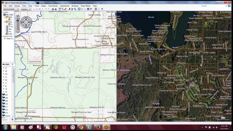
Here is side by side of onx alone vs overlay
Very cool,thanks for the update Steve, looks like I should update mine!
The detail is far better than any plat I have bought. In a subdivision area most plats will just show a block labeled small tracts. This still shows the individual lots.
Just an incredible tool!!!
Steve my ex Brother in law thought Small Tracts was a guy that owned a lot of land when he looked at the plat map.
He is the gift that keeps giving.
danbark that is hilarious. That brother in law must have been from Illinois......
We just released a new update for WI! Check it out here: http://www.huntinggpsmaps.com/catalog/product/view/id/9086/s/hunt-wisconsin-garmin-gps-archive
The chip can also be used in your computer, you just need to plug in your GPS and open up Basecamp, all your GPS waypoints will show up in Basecamp.
Let us know if you have any questions by sending us an email at [email protected] or by calling us at 406-540-1602
Make sure you double check the forest crop listings as there are some inaccuracies with On X
onXmaps,
Would you please post your inofo to Bigwoods so we can all see it. I have found also found many discrepancies from what OnX maps and WDNR maps show.
OnXmaps
When I buy a chip do I need to do a 30.00 update right away to get the most current data?
Thanks!
Drop Tine, When you buy the chip you will register it on our website and find what version chip you have (when you plug it into your GPS). This will indicate if you have the most current data. You will receive a year of free updates once you've registered and get the latest updated information for that state.
Not having to plug in the GPS is why I prefer the computer version.
Also gives you far more management ability. If you need a chip for a larger number of satellite maps. It is real nice to put the huntmaps on the gps memory directly.
Some units can be slowed down when accessing a chip. Would have to look to be sure of amount of space used. I am able to put the hunt maps/ topo maps/ sat maps. Of my primary hunting area all on the gps memory. No chip to worry about failing, popping out, etc. I also need the speed, reduced lock ups, etc. That most do not though.
This does leave your chip spot open if needed for hunting other areas on other occasions.
All depends on how you want to use it. In any case a must have.
I did double check it. If you are a RMEF member there is a phone app version for free. Just have to log to -- my rmef --
Elkaddict, sorry I misses your question and then was at a trade show the past few days. The MFL data only includes lands that are open. We have had issues in the past and not do not provide closed or both open/close data. Again feel free to call us at 406-540-1602 or send an email to
[email protected] if you have more questions.
Thanks
The only thing I really dont like about this. Is if you want to stay updated. You essentially are going to be buying the program yearly. Yes, free updates for a year. However only for the year you purchased. I double checked and I had bought mine in Oct last year. In just a few months I have to buy the program again. Just to get the updated maps. Not sure and no way of knowing if there is enough updated information in my area to even warrant it. Just the way it goes I suppose.
Yes it is too bad you have to spend $30/year to update. I have seen many inaccuracies with the forest crop listings and not just those that are closed. My own land (which was never in forest crop open or closed) showed up as forest crop open on the maps. I contacted them and asked about changing it and was told it would be changed during the next update. It didn't get updated and was still shown as FCL open as of last fall. The chips are great for showing land boundaries and owner names, but the topos have no detail and the forest crop listings all need to be double checked.
I found out that the three counties I hun the most only have partial data. So no need to spend 99.00 right now on Wi.
Steve White, you are correct this is yearly information and to clarify a bit the chip is $99.99 and free updates through the end of the year then the updates are $30 for another year. And there is a way of knowing about our updated information. You can view when and what we update for each state (I am using WI as an example) here: http://www.huntinggpsmaps.com/hunt-wisconsin-garmin-gps and click the "change log" tab. It is up to you when you want to update as you can wait 5 years before you purchase an update as still get the latest version of that state.
Bigwoods, to address your issue with the FCL this is generalized data to the quarter quarter section from the WI DNR. I also sent you a PM.
If the forest crop info is not accurate, it seems it should not be included as part of the maps. The land in question is not in forest crop and is not listed as so with the DNR