Mathews Inc.
Northwest WI Flooding
Wisconsin
Contributors to this thread:
orionsbrother 12-Jul-16
razorhead 12-Jul-16
orionsbrother 12-Jul-16
Jeff in MN 12-Jul-16
orionsbrother 12-Jul-16
smokey 13-Jul-16
orionsbrother 13-Jul-16
Jim Leahy 13-Jul-16
razorhead 13-Jul-16
orionsbrother 13-Jul-16
alderrub 13-Jul-16
Jeff in MN 13-Jul-16
orionsbrother 13-Jul-16
Jeff in MN 13-Jul-16
smokey 13-Jul-16
smokey 13-Jul-16
orionsbrother 13-Jul-16
Jeff in MN 13-Jul-16
smokey 13-Jul-16
smokey 13-Jul-16
smokey 13-Jul-16
orionsbrother 13-Jul-16
Mike F 13-Jul-16
smokey 14-Jul-16
smokey 14-Jul-16
smokey 14-Jul-16
Jeff in MN 15-Jul-16
smokey 15-Jul-16
Jeff in MN 15-Jul-16
smokey 15-Jul-16
MuskyBuck 26-Jul-16
smokey 26-Jul-16
Jeff in MN 26-Jul-16
MuskyBuck 27-Jul-16
orionsbrother 27-Jul-16
Jeff in MN 27-Jul-16
orionsbrother 27-Jul-16
smokey 27-Jul-16
smokey 27-Jul-16
orionsbrother 27-Jul-16
smokey 27-Jul-16
orionsbrother 27-Jul-16
Jeff in MN 27-Jul-16
orionsbrother 27-Jul-16
smokey 27-Jul-16
Jeff in MN 28-Jul-16
Gunner 280 28-Jul-16
GoJakesGo 28-Jul-16
smokey 28-Jul-16
Jeff in MN 28-Jul-16
smokey 29-Jul-16
smokey 13-Aug-16
smokey 13-Aug-16
Jeff in MN 14-Aug-16
orionsbrother 14-Aug-16
12-Jul-16
My e-mail and text messages lit up today with pictures, messages and stories about the storm. It looks like at least two people have lost their lives so far. And there's quite an amazing amount of destruction.

I hope no one here lost anyone. I hope no one here had property destroyed or is stranded by washed out roads.

One heck of a storm. The raw power of water is amazing.

From: razorhead
12-Jul-16
I saw what happened to the High bridge area, in Ashland co,,,,,, hope for the best for friends in the area

12-Jul-16
Yeah. It's a mess. No one can get anywhere in chunks of Ashland, Bayfield, Iron etc. washout all over.

I talked to one guy who told me a creek that is normally three foot wide is now about 300ft wide with whole trees washing down.

The dang Bibon Marsh filled up with enough water to over top 63. There's a lot of feeders into the Bibon Marsh, but that's a big area to wind up with an extra three ft of water. I think it's better than fifteen square miles.

Supposedly the Bad River water gauge recorded a fifteen ft rise in the river in less than six hours...before it was ripped away.

Hoping all is well with Steve, Jeff and others in and around those areas.

From: Jeff in MN
12-Jul-16
I am fine, we got about 6 inches. Low parts of my lawn are under 2' of water. But that is what the low spots are for, keep water away from the buildings yet keep it from running straight into the lake. Propane tank had water up about a foot on the tank, good thing it is 70% full. The lake is up within inches of 100 year flood level AGAIN. Wish the rain would have washed out the beaver dam that has been holding the lake up way too high. I just don't understand why the tribe will not let that dam get blown out or at least kill/trap the beaver out. Another one of those because they can things.

I have not been out in my woods yet to see what happened there. I am still logging huge red oaks that came down in the storm a few weeks ago. Keeps raining and too messy to use the skid steer most of the time. Ground is saturated, prime for more trees to take the fall if we get wind.

Heard of roads washed out around the area, 77 I think west of Hayward and 27 north. I heard there was a huge washout somewhere around Mellen.

Minnestoa got hit way worse. The scope of this event was huge. Covered most of Iowa, Minnesota, Wisconsin and probably more.

12-Jul-16
Jeff - My wife's been following this because of family and friends in the area. She just came across something that as of 4:51 today, WI has shut down trucking in Ashland, Bayfield, Burnett, Douglas, Iron, Sawyer and Washburn counties.

Supposedly no trucking in, out or through until all main roads are assessed. If you're low on groceries, you may want to pick up a couple days' worth.

Sounds like anyone in Ashland might want a few more.

From: smokey
13-Jul-16
Go to the County's website for information and photos. I was out checking some damage and taking some photos.

At one site the USGS guys said the flood auto monitor quit working and they were trying to record data with portable units but with the swift current they had to go to old manual methods.

At that site the water was over the bridge and climbing. There was an active power transformer submerged nearby. You could also hear boulders clinking passing under the bridge. I stayed back off the bridge and did not go past road closed signs while there.

I pulled a camera Tuesday and water is standing in every low spot in the woods.

Many of the secondary roads did not have closed signs but were severely damaged. I saw ATVs driving some at high speeds. The ATV and bike trails have a lot of damage too.

True, there are many areas that are closed off due to washed out roads. It will take some time to fix all of this.

13-Jul-16
Smokey - Post up some of your pics if you would. My wife was showing me some of the pics from the Bayfield website. Crazy how powerful moving water can be.

13-Jul-16

orionsbrother's embedded Photo

13-Jul-16

orionsbrother's embedded Photo

13-Jul-16

orionsbrother's embedded Photo

13-Jul-16

orionsbrother's embedded Photo

13-Jul-16

orionsbrother's embedded Photo

13-Jul-16

orionsbrother's embedded Photo

13-Jul-16

orionsbrother's embedded Photo

13-Jul-16

orionsbrother's embedded Photo

From: Jim Leahy
13-Jul-16
My bear buckets that were empty in my Pick up had 10 inches of water in them-live 5.5 miles North of Hayward on Nelson lake rd.- horrible Lots of trees that just fell on my property and my bait locations from the root systems just being saturated-hope it doesn't get windy.

From: razorhead
13-Jul-16
whats the name of that road, pictured, going to spend some time musky fishing there near high bridge, early October

13-Jul-16
razorhead - I didn't take any of the pics. They were all forwarded to me. I think that 13 is washed out in a couple of places near High Bridge as well as a lot of roads all around there.

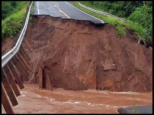
My wife has family who's place is near Grand View. Apparently, the fourth picture is 63 at Twenty Mile Creek...but I'm not sure.

From: alderrub
13-Jul-16
Our hunting cabin is right in the middle of all of this. So far I don't have any word as to damage on our property and with all the roads washed out it might be some time before we know. The white river runs near our place and had it's highest recorded levels since they started keeping track.

From: Jeff in MN
13-Jul-16
Wow, impressive pictures. I just got back from running bear baits. I saw probably 5 logging trucks fully loaded so either they did not get the word or some trucking is being allowed.

Woods are wet, I had to bail water out of some of the bait sites but that isn't too unusual. I did not run into any roads that had any serious damage. I am thinking most of the really serious damage is north of Hayward a ways.

If anyone has a place not too far from Hayward and wants me to check out your place send me a PM with your phone number. I will do what I can.

13-Jul-16
None of those pics are mine Jeff. They've all been forwarded to me by friends and family who've pulled them from Facebook and the internet. I just posted them because I thought the same thing you did.

I'm wondering how long it'll take before they'll have some of those roads put back together? Army Corps of Engineers? Visiting friends in that area might be a PITA for quite a while.

Who knows about the trucking? I just know that I don't think I'd want to test any of those water crossings in a loaded logging truck.

From what I'm hearing, it sounds like the worst of it in Wisconsin is in a trapezoid from Cable to Ashland to Saxon to Mellen. But I'm following it because of personal connections and don't have any access to direct information. I'm hoping some guys up there can post pictures and information that I can then share with my wife.

Cable to High Bridge to Saxon is pretty much a straight line. My guess is that's a good estimate of the main storm track.

Here's to hoping all is good at your place alderrub.

From: Jeff in MN
13-Jul-16

Jeff in MN's Link
Link is Duluth news list of closed roads. I am sure it is only a partial list.

Check out washburn county sheriff facebook page. Some interesting pics of whirlpools spinning above culverts. Also warns of townships running out of signs to close roads and mark hazards, so watch out on secondary roads.

From: smokey
13-Jul-16

smokey's Link
Here is one link.

all trucking is stopped, maybe a few not knowing or just not following the order. Gov. Walker declared it disaster area.

It will take a while. sort of wondering if the Forest Service will call in a Type 3 team to help manage this. Today I was upstream near Cable looking at Namekagon River and it was down but near my house the river was WAY up.

Go to the County's emergency websites for more information. As for photos I know there is one guy on FB posting hundreds, not all his. Jon Olkonen I think it is.

From: smokey
13-Jul-16
Pics 5 and6 are Highway 13 near Highbridge I believe.

#4 might be 20 Mile creek but have not seen that view before. It may have been taken from the trestle.

13-Jul-16
Couldn't find your guy's Facebook posts Smokey. If you happen to stumble across his name, please post it.

From: Jeff in MN
13-Jul-16
Smokey, Bruce's son went to kayak with some friends on the Namekagon tonight. Bruce thought it was a bad idea. While I was there the kid called and said there was a sign at the landing that if you were caught on the river you would end up in jail or something like that.

From: smokey
13-Jul-16
I made a correction to the name, sorry for the mispelling. It is Jon Olkonen. There or some others too. I am sure there will be a lot in papers and the 'net soon.

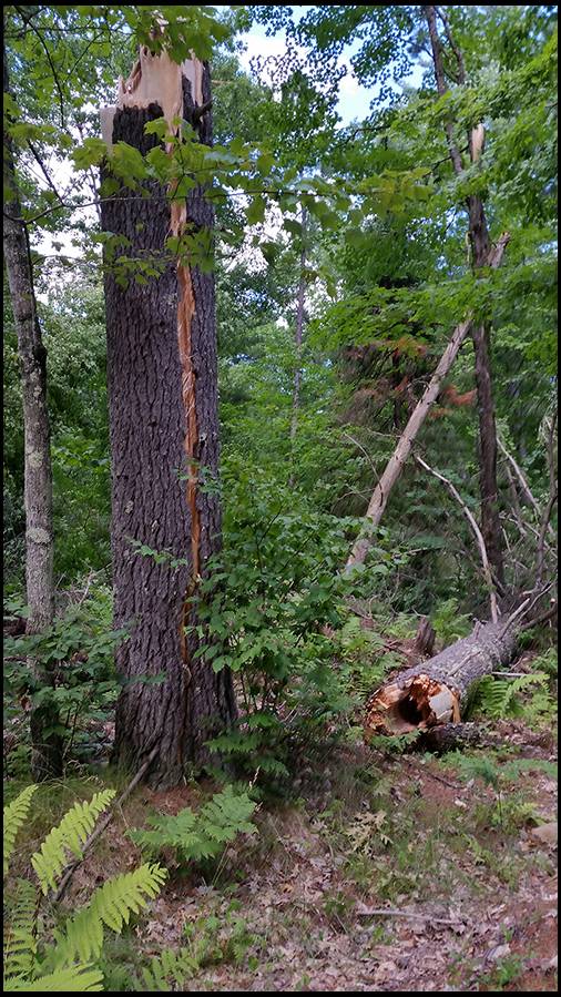
One of my pics from the storm but not of flood damage. Today will working on the Birkie trail I found this lighting struck white pine, thankfully it fell into the woods so I don't have to clean it up. Thankfully too it rained so it did not start a fire. Rare here but it does happen.

From: smokey
13-Jul-16

smokey's embedded Photo
I deleted the image cause it was way too big and might slow down your computers. So here is the adjusted version.

From: smokey
13-Jul-16

smokey's embedded Photo
Here is an image taken with my Nikon just before the storm. I was trying to get some lightning photos but the rain hit so hard and fast all I got was soaked.

13-Jul-16
Wow! That's a cool pre-storm picture Smokey!!

I'll check out the updated name. Thanks.

From: Mike F
13-Jul-16
Our thoughts and prayers go out to all of those affected.

From: smokey
14-Jul-16

smokey's embedded Photo
Area affected.

From: smokey
14-Jul-16

smokey's Link
Also, USFS has closed the area from HWY 63 east to HWY 13 and north from HWY 77. Some roads under Town authority are open but USFS roads and lands are closed. Fines up t0 $5000 and/or 6 months in the pokey.

From: smokey
14-Jul-16

smokey's Link
More USFS info

From: Jeff in MN
15-Jul-16
I had not heard of damage to docks and boats from the rushing river waters until seeing this Michigan DNR news article.

In the wake of this week’s severe storms in the western Upper Peninsula, officials at Porcupine Mountains Wilderness State Park posted signs today cautioning boaters about a debris field floating in Lake Superior, which was expected to reach the shoreline of the park at about 11 p.m. July 14.

Federal officials said the debris is the result of 85 boats being damaged or destroyed at the SaxonA map graphic shows the area where the debris field is expected to reach Porcupine Mountains Wilderness State Park. Harbor Marina following severe weather Monday, which included flooding.

The marina is located on Oronto Bay, at the mouth of the Montreal River along the Wisconsin-Michigan border, a few miles west of Porcupine Mountains Wilderness State Park.

“Park staff posted signs this afternoon which caution boaters intending to use Lake Superior waters along the shoreline of the park, within an area where the debris is expected to be located tonight,” said John Pepin, deputy public information officer for the Michigan Department of Natural Resources. “Boaters could encounter floating safety hazards amid the debris. Some items reported earlier today included a drifting boat, a dock and woody debris.”

Material was expected to continue to drift to shore throughout the weekend.

Michigan Department of Environmental Quality officials have been notified. In addition, the U.S. Fish & Wildlife Service, U.S. Coast Guard, U.S. Army Corps of Engineers and the National Oceanic and Atmospheric Administration are also working on the issue.

Storm damage at the park has forced the temporary closure of sections of trail and cabins and backcountry campsites in the northwest part of the park between the Little and Big Carp rivers. The campsites and cabins are scheduled to reopen July 28.

/Note to editors: An accompanying map graphic and photo are available below for download and media use. A caption follows. Credit: Michigan Department of Natural Resources, unless otherwise noted.

Signs: Bob Wild, a park interpreter at Porcupine Mountains Wilderness State Park, posts a public emergency notice today cautioning boaters against a floating debris field expected to reach the park shoreline tonight.

Debris map: A map graphic shows the area where the debris field is expected to reach Porcupine Mountains Wilderness State Park. (National Oceanic and Atmospheric Administration image)/

From: smokey
15-Jul-16
Also, Colton Flowage near Minong is no more. The dam broke and nothing but a creek running there now. Oh, at least the waterfalls are now exposed.

From: Jeff in MN
15-Jul-16
Is that what caused the wash out on Hwy 77?

From: smokey
15-Jul-16
Don't think so.

From: MuskyBuck
26-Jul-16
I see USFS roads are closed again north of HWY 2 from high winds from a storm on July 21st. I'm wondering how severe the damage was and timeframe for crews to clear out the roads.

From: smokey
26-Jul-16

smokey's Link
I am not sure of the time frame. I have been out clearing the Birkie trail and most of that damage is on the north end. Lots of trees down there. One can go for stretches with no damage then come upon a patch where trees all down. That storm had more damage north of 2 as you mention but still some around here.

Go to the website for Chequamegon, they keep updates there almost daily. Also check out the County website for information.

From: Jeff in MN
26-Jul-16
There was another fatality about a week ago resulting from the first storm in this thread. A woman drove through/around two sets of road blocks on US-63 near Grand View. The washout is 55 feet deep and she landed behind the large cement culvert at the bottom of the washout. A worker was inspecting the washout site and saw the car, she was air lifted to Duluth but died as a result of her injuries.

From: MuskyBuck
27-Jul-16
Thanks for the link Smokey. I was planning to get up to Bayfield this weekend, but it might be wise to wait another week.

27-Jul-16

orionsbrother's embedded Photo
MuskyBuck - Where are you heading? PM me if you'd like.

I was just up there with a buddy. Some of the roads that are marked closed are actually passable, but according to a friend of mine, they are writing tickets if you don't have a local address that you are heading directly to.

Some of those roads will take a very long time before they're open though.

From: Jeff in MN
27-Jul-16
Does anyone know of a map online that shows all of the current storm related road closures? I have not seen one. I know most of the minor closures have reopened but ones like at Grand View and I think some on US 2 are still closed. It is a pain to try to read articles to figure out what is open and most are out of date anyway. I checked a couple of counties (a while ago) and found nothing of value there either.

27-Jul-16

orionsbrother's Link
Here you go Jeff

27-Jul-16

orionsbrother's Link
Also..

From: smokey
27-Jul-16
Jeff,I posted that link before you posted the request. Doesn't it show up on your screen?

Interesting thing in the photo Orionsbrother posted. It has ATV tracks in it. Maybe the road was not posted but last weekend I saw road closed signs with plenty of ATV tracks going around them. I won't feel sorry if the get a ticket or get hurt. Closed means closed!

From: smokey
27-Jul-16
I just looked at the CNNF website and the map for the July 11 storm road closure map has not been updated since the 22nd. The Washburn District map closure is buried under the Closure order.

I sent an email asking if information will be updated.

The map on the Bayfield County website is current and updated most every day around 2 PM.

27-Jul-16
smokey - Yep. Those were not our ATV tracks.

There were some township guys surveying roads using ATVs for access...and there were some "yahoos" riding through creeks and such. Wouldn't bother me a bit if those guys wound up with tickets.

The only tracks we left were from our boot lugs.

From: smokey
27-Jul-16
Thanks Orionsbrother. I did not think you were the ones making those tracks. I apologize if it sounded that way.

27-Jul-16
No sweat smokey. Just clarifying.

From: Jeff in MN
27-Jul-16
Smokey, I tried the link you posted but it just took me to a general info page. I looked it over and didn't see anything that jumped out at me as being a road closure map.

That map Orionsbrother posted the link for is cool, especially the pictures that you can click on.

27-Jul-16

orionsbrother's embedded Photo
This had been a nice little stretch of trout stream with a few small pools.

From: smokey
27-Jul-16

smokey's Link
Jeff, like anything with the USFS it takes some deciphering where they put things. It's there but not real obvious. Also since they don't update it often I recommend the County website. The link from Orionsbrother is the map from the County site; the main page has more information. I think I posted that in the past somewhere here too.

But then I might be confused. So much chainsaw work lately has me totally exhausted.

From: Jeff in MN
28-Jul-16
"So much chainsaw work lately has me totally exhausted."

On Tuesday I finally finished cutting saw logs out of my oaks that fell over, broke at the stump, or leaned into other trees in the last 3 storms. Then carrying them out to my driveway for their trip to the mill. So I can relate to what you wrote.

Do you have equipment working with you to lift stuff off the trail or do you have to cut everything small enough to handle it by hand? That would be a PITA.

From: Gunner 280
28-Jul-16
I have a bear bait up on the closed forest roads. Put a camera and bait out 4th of July weekend. I have been up twice to try and get to it to no avail. Anybody think they will be open by bear opening?

From: GoJakesGo
28-Jul-16
The amount of water is crazy! As it flows southward it keeps creating more problems. The Willow Flowage has been full all year even as they swamp the Tomahawk River. Last year parts of the flowage had leaks-glad they got those fixed.

The Tomahawk flows into Jersey City Flowage which doesn't have the flood gates to remove mass amounts water into the WI River so thats being monitored closely.

The Spirit Flowage dam is busted and they cant hold water back without major repairs scheduled for next year.

The Nokomis and Rainbow Flowages also have water levels I haven't seen in 10 years. The City of Wausau had kayak tournaments which usually causes massive water level fluctuations in the Flowages-this year I couldn't notice.

From: smokey
28-Jul-16
Jeff, no equipment, just toss by hand. I cut one dangerous tree today that had me on my toes. Gave it plenty of thought before working on it.

Gunner, if you PM me I might look into it. I had some cams out but was finally able to get to one (no big bucks on it) the other is off a closed road yet.

GJG, its a good thing some of the water flows north or it would be worse. At one time a week back the dam on St. Croix was close to going out. Many were worried.

As if my part time job at the Birkie and cutting trees there isn't enough, Friday I am helping cut out a part of the race course for the Chequamegon Fat Tire race. At least the temps have dropped.

From: Jeff in MN
28-Jul-16
I sure hope most of the national forest opens up SOON. I am afraid bear hunters that would have gone there will start to focus their attention where some of my baits are at.

From: smokey
29-Jul-16
I stopped by the District office this morning and the map on the CNNF webpage is current even though it says the 22nd. It will be updated soon with more open roads but there is a lot of work yet top be done out there.

They are giving citations to anyone behind closed signs unless solid reason for being there.

From: smokey
13-Aug-16

smokey's embedded Photo
Still a lot of roads closed. I took a bike ride to get these photos. I have not been able to get cams up in some areas because of closed roads. Maybe I will bike in to get it done. The arrow is pointing to my bike.

From: smokey
13-Aug-16

smokey's embedded Photo
Another view.

From: Jeff in MN
14-Aug-16
I heard 63 is open at Grand View. If true that was amazingly fast.

14-Aug-16
There's a short detour on Sweden Rd to get around the washout. I suspect that's what they meant by saying 63 is open.

I don't think it's possible that 63 has been put back together. I think that detour will be used in 2017.

  • Sitka Gear