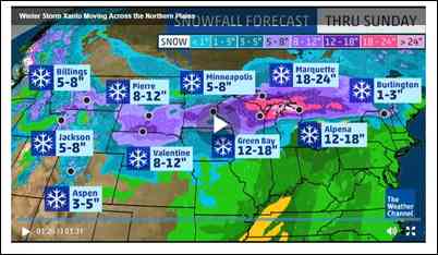
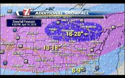
23" of snow coming to NW Wisconsin
Wisconsin
Just what we do not need, 23". Saturday is a ways out yet and this is just one prediction but will it ever end. I hope this is fake news. I might need to use snow shoes just to get to the skid steer to start plowing.
Jeff, if you look at the other weather sites, none of them state that much snow? I am hoping the rain knocks down alot of it. I was just in the Accuweather site and they wern't saying those amounts?
I hope those other predictions are more accurate. National weather service prediction for Hayward does not look bad. Maybe Pivotol Weather is fishing to increase their click count to boost advertising revenue.
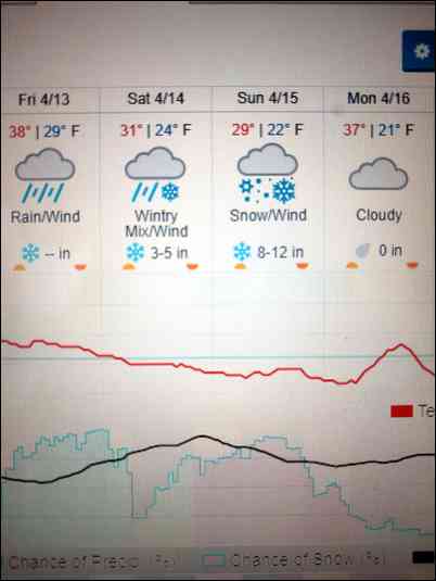
Tonight Rain before 4am, then a chance of rain and snow between 4am and 5am, then a chance of freezing rain after 5am. Low around 32. Southeast wind around 5 mph becoming northeast after midnight. Chance of precipitation is 80%. Little or no ice accumulation expected. Little or no snow accumulation expected.
Thursday A chance of sprinkles, flurries, and freezing rain before 1pm, then a chance of sprinkles after 5pm. Mostly cloudy, with a high near 46. North wind around 5 mph. Chance of precipitation is 10%.
Thursday Night A chance of rain before 3am, then a chance of rain and snow. Cloudy, with a low around 32. Northeast wind 5 to 10 mph. Chance of precipitation is 50%.
Friday Rain, snow, and freezing rain before 1pm, then rain likely between 1pm and 5pm, then rain likely, possibly mixed with snow after 5pm. High near 38. Breezy, with a northeast wind 10 to 15 mph, with gusts as high as 30 mph. Chance of precipitation is 80%.
Friday Night Snow likely, possibly mixed with rain, becoming all snow after 10pm. Cloudy, with a low around 24. Blustery. Chance of precipitation is 60%.
Saturday A chance of snow and freezing rain before 11am, then a chance of snow. Cloudy, with a high near 32. Breezy.
Saturday Night A chance of snow. Cloudy, with a low around 22. Blustery.
Sunday A chance of snow. Cloudy, with a high near 34. Breezy.
Sunday Night A chance of snow, mainly before 1am. Mostly cloudy, with a low around 19.
I'm pretty close to the 24" area of that map and my local forecasts are saying 4" at most. Looks like we could get 1-2 inches of rain on Friday and depending how fast that moves out will likely play a role in how much snow we get. 1 inch of rain can equal a lot of snow.
Yes, quit posting that other one.
Heck, I got it from Facebook, it must be true. Specifically from a link to: Isanti County Weather Update, seemed legit at the time.
I should have known better. I type this as news is on talking about Zuckerberg testimony.
The weather channel says up to 9 inches possible for Lacrosse, our local station says maybe 2 inches.
FACEBOOK!!! Jeff, are you a gossipy little girl? Stop getting weather off facebook, we need that snow up there gone.
NOAA is saying 1-3" for Washburn County, other than rain mixed with wet snow at times.
I don't get weather from facebook, I use national weather service. My daughter posted this on my feed and I got carried away with it and failed to verify it before posting it here. My facebook use is limited to posts from a few of you, friends, and family. I try to ignore the junk that gets in there. There is a lot of good in facebook, like I am connecting with old friends from high school, one of them now lives in Ladysmith, not far away. I do get frustrated with the ads they push to me, often the same ones over and over. Wish I could pay them $10 a year and never see an ad.
I looked at 3 different sites this morning (accuweather, Weather channel and weather underground) because that's what I do for a living, snowplowing and landscaping. They agree with each other. Anywhere from 10-18" of snow in the center of the State. I hope they are wrong as we pulled out all snow plowing stakes on Monday and pulled the salters off of the trucks. AGGHH. p.s. Jeff, I didn't look at facebook.... yet.
Trapper, I'm not seeing that. Total amounts I'm seeing are 6-10 in Eau Claire and Phillips 3-6". That's for Friday - Sunday.
Well I'm disappointed to see what's ahead. I had plans to take my son on His first bird hunt this weekend. Up to 40 MPH winds Saturday and 5-8 inches of snow for Sunday.
Looks like the worst weather possible for the youth hunt.
Hopefully storm moves more north west. Love snowmobiling logging roads in may, been a couple years since had the opportunity. I'm working on my rain dance techniques down here thou. Need this ground thawed and dried asap.
Local station is now saying there may be some truth to the 12 inches. So much for putting the snow blowing tractor in the shed and opening the garage gym back up.
here's the weather channel
if it was the east coast it would prolly be one of those Bomb-Cyclones i keep hearing about.....................
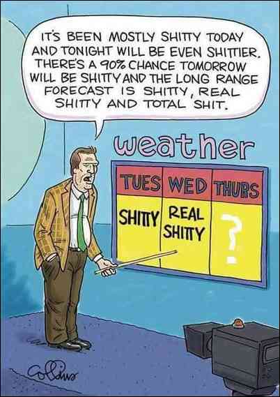
and the local weather women's words of wisdom this morning was dont believe the amounts you see on social media ROFLMAO
Well, Accuweather has Phillips at 21% chance for more than 10 inches (ouch), and 49% chance for less than 12 (better).
I just got a storm warning for 3/10 inch of ice with the snow. Just when you thought it couldn't get worse.
So does anyone here think that if we get pounded the CDAC's/DNR will be proactive and readjust antlerless quotas in affected areas? I sure as hell won't be holding my breath on that one.
Probably not in my county. Our DNR biologist that “advises”/tells the committee what to do thinks that there are deer hiding behind every tree and those deer are eating all the baby trees causing no regeneration. She thinks oaks and maples will be extinct soon do to too many deer. Thus the committee is recommending a doubling of the antlerless quota for our northern forest area.
Winter might last through June the way things are going. Maybe CDAC should hold the antlerless quotas open till then. ;-(
BTW, Trapper this is all your fault for pulling your marker stakes too early.
Good news about the youth hunt, is they have 7 additional days to hunt, just like the rest of us, and you can kill a turkey on any day, of any season.
Youth can hunt all the turkey seasons to fill their tag?
I heard 6-10" from Oshkosh north. That would likely put an end to my week 1 tag in Shawano Co. I may have to go up just to rake off the cabin roof !
18 to 24 at my cabin in the UP, possible,,,,, gee I just cleared it out, well be back on Wed,,,,,,,,, no sooner will my truck pull in, and chain saw start, and here come the deer
This pic seems appropriate.
No peeps, I'm suggesting that a person can kill a bird in any weather, and The youth tag is essentially a 9 day tag. 2 day youth hunt, and their 7 day season the tag is designated to).
Maybe I can reverse it Jeff, I have 3 guys putting sno stakes back in today and 4 guys mounting salters back on the trucks.
You will need to charge your clients double to cover your additional prep costs.
Nah, Something’s I just do out of the goodness of my heart.
Well, it looks like it will start going up hill after this weekend as far as melting that snow up there. I hope the deer can hold out.
Now that I can agree with!!
New update - possibly 17" total by Sunday night for Rice Lake area. I sure hope not, the deer need a break.
If we get pounded we all better start leaning hard on our CDAC/DNR to adjust 2the antlerless quotas.
10:20 PM, got back to SE Mn after spending a day in EauClaire and there are snowflakes falling an inch in diameter. Not kidding either. I have never seen flakes that big. Had to be clusters of a whole bunch of normal flakes. Thunder too.
That was/is a huge storm. The link is green bay radar but the impressive thing is to look at the radars for MN, IA, WI, MI. It will change by the time you look at it but huge parts of all 4 states are still getting hit.
I am in SE MN now, we only got about 3 inches here. Good thing because I put my snow plow and garden tractor mounted blower in the back of the shed and would be hard to get to. I do have a walk behind blower I could get to but at this point do not need it. What are your totals so far?
I was in Eau Claire helping my daughter move out. We were racing the storm and got back to MN with her just as it hit here.
About 2-3 inches in Dunn Co but it stopped snowing within the half hour. Calling for 13 inches total.
Now they are saying up to 10 inches in Lacrosse with another 6 wed night. Turkey hunting should be interesting.
Just unwiterized my snow blower..... more to pack for turkey hunt
Did you mean 'unsummerized'?
10 inches plus at Wittenberg. Got to dig out my ice fishing suit
3" in eau Claire. It looks like it split in half. Part in mm and part in Michigan. Courious to see what the mn half does.
Just got word, no new snow in Hayward over the last week but looks like it is about to hit them now. 10:30 AM. Also a lot of the existing snow has melted around our neighbors house with the recent warmer weather.
SE Minnesota, snowing hard now but doesn't look like it will last long.
This photo was from near Shawano this morning
We had 3" last night, but the worst is yet to come.
Tonight Snow. The snow could be heavy at times. Patchy blowing snow before 1am. Low around 22. Blustery, with a northeast wind 15 to 20 mph, with gusts as high as 30 mph. Chance of precipitation is 100%. New snow accumulation of 5 to 9 inches possible. Sunday Snow. The snow could be heavy at times. High near 30. Northeast wind around 15 mph, with gusts as high as 30 mph. Chance of precipitation is 100%. New snow accumulation of 3 to 7 inches possible.
Spring scout in Bayfield maybe by mid-May. Lol
2” north of Merrill. They’re still saying 10-16” tonight into tomorrow.
Yup, this storm is a long ways from over, not looking good for the NW corner of the state. As is a lot of the rest of the state too. At least most of the rest of the state probably won't have ice bergs on their roads.
Strong northeast winds will impact areas at the head of Lake Superior, including Two Harbors, the Twin Ports, east towards Bayfield and Ashland today. Winds 30 to 40 mph, with gusts of 50 mph, will be possible. This will result in difficult driving conditions and large waves on Lake Superior, which will affect lakeshore areas. On lakes where thick ice remains, including Lake Superior, chunks of lake ice may be picked up by the waves and crash onto shore, including some stretches of roads which are adjacent to the lake. Lakeshore flooding is possible, which could damage property and cause water on parking lots and roadways near the lake. See the Lake Shore Flood Warning and Wind Advisory for more details.
Moderate to heavy snow will then move into northwest Wisconsin and adjacent areas of northeast Minnesota tonight. Northeast winds will remain gusty overnight, which will lead to reduced visibilities to one-half of a mile or less at times. The heaviest snow is expected to start falling after midnight tonight. Those with travel plans today and tonight should be prepared for hazardous travel conditions. See the Winter Storm Warning and Winter Weather Advisory for more details.
.DAYS TWO THROUGH SEVEN...Sunday through Friday
Moderate to heavy snowfall will continue across northwest Wisconsin and adjacent areas of northeast Minnesota during the day Sunday. Some lake effect snow will continue through the day Monday along the South Shore of Lake Superior. Through Monday, this storm system could bring between 12 to 18 inches of snow accumulations to northwest Wisconsin, with amounts between 6 to 9 inches along the North Shore of Lake Superior.
Jeff, were you in Eau Claire yet yesterday when we got that hit by that hail. It piled up quickly and actually got slippery. Here in Bloomer we didn't even have enough snow to cover the grass this morning. It is snowing hard now and accumulating quickly.
The heavy snow and high winds has just arrived here in Washburn County.
This is the updated “additional” snow accumulations for the storm.
Rut, I think I left EC a little after 6:00. We were getting some sleet off and on all day including about the time I left. I hit a little more on the way, hit heavy winds after crossing the river at Wabasha. I didn't want to plow my place here today because I knew the ground/driveway was mush plus the truck was still hooked to the trailer so I used a blower on my lawn tractor. I was throwing a lot of brown snow, gravel, and mush out on the lawn.
I think people will remember this April storm for a long time, especially because of the huge area it is affecting in addition to some deep snow/sleet and strong winds.
I don't see Trapper posting today, I bet he is out in the thick of it.
Here is the current (3:20 PM) NW Wisconsin 'situation report'. They don't do these too often and this sounds nasty. Click on the link. Not sure if this will stay at the link or if it will get updated as the storm progresses. Just what the deer (and the people) up there do not need.
Meanwhile in Wausau

Meanwhile in Wausau
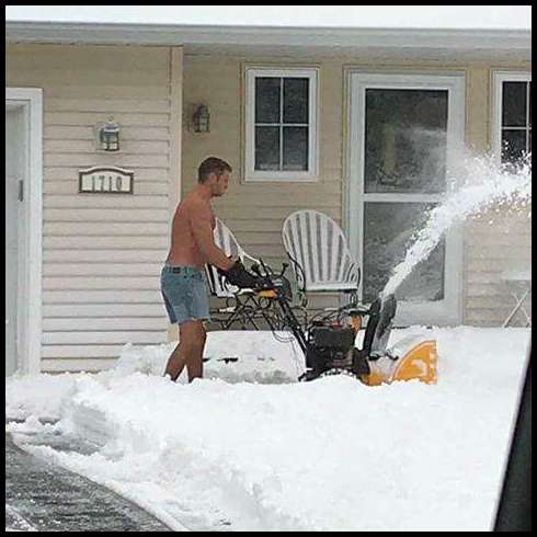
Wish I could see if he is cheating and wore shoes. He is cheating with the gloves on. Just another day in Wausau.
Wausau area is getting it's fair share. Most areas received about 6" last night and tonight we may get double that. Snow plows haven't been out. Im finding snow drifts 3' high across roads. With modern traction control im finding lots of stuck cars.
Anyone in Forest/Florence/Marinette county?
I saw a map estimating 20" of snow.
This storm is like a fart in the wind. We’ve gotten 4” maybe total so far. Not complaining one bit though.
Yes tweed....... about 18" here right now and still coming at over an inch an hour. Im in western Marinette county.
Here is my periodic lesson on how to rotate a picture you posted.
Click 'image tools' at the top right of the pic. Click the appropriate rotate arrow as many times as needed, save it.
I don't think we have much over 8" here in Chippewa county. I have been out plowing since 5 this morning. Those old church ladies are always nervous about getting out of the driveway;) We have some hellacious drifts. One thing that baffles me is the county, city, and township plows are non existent. We get 2" in December and multiple plows are on every road. We get this and nothing.
Could it have anything to do with weight restrictions on some roads? I doubt it because I would think plow trucks would have exemptions. I was hearing similar complaints from a suburb south of Minneapolis, specifically on a road usually plowed frequently to keep it open for emergency vehicles.
Snow budgets are gone now. They dont want to pay the overtime. "Its the shovel leaning" time of year, not snow removal.
Marathon Co was/is a mess. For some reason during the worst storm of the year they don't call plow drivers in until most 4x4 trucks cant drive on the road. Then 1/2 the plow drivers can't make it into work! 4x4 tow trucks were getting stuck ON the road trying to winch out cars. I thought WI was smarter than the east coast winter sissies but 20" of snow has shut us down
I got out while the eye of the storm was here and Sawyer County trucks were plowing but not my Town trucks. I think they will wait until it ends. At 6 AM I had 2", then it let up for a few hours before starting again. Now, at 5 PM I have another 6".
Weird hearing the low totals from northernish counties. In the Oshkosh area, I can only guess but probable 15" and still coming down, As temps swung back and forth from freezing, there's at least two layers of ice mixed into the accumulation. Ice on trees followed by snow, then ice then snow, mixed with high winds reaking havoc on trees. Terrible time of year for ice and deep snow for deer. I heard the winds were strong enough that the Perkins in Oshkosh lost their flag pole.
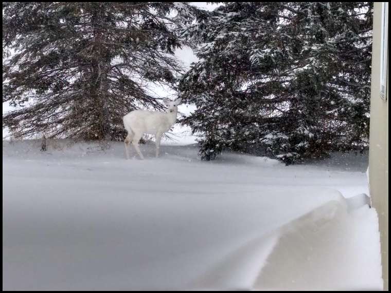
Five of our local deer family are eating my wife's hostas. They are prolific plants so she is OK with it. See pics below.
Plenty of white stuff here in Taylor County.

Monkeys watching the deer

Monkeys watching the deer
Sorry, uploads of the pics kept failing.
About 7 inches here at my house in Lax county. Another storm coming wed, opening day of my Turkey hunt should be interesting. 60 mid next week, have to get the shorts out. Lol
Screwball, very cool pic. Is that in your yard?
So since I posted about the plows not being out they have been by 5 times;) I posted about it at around 2, it's now 7:33. We have also got about 4 more inches of snow in that time and it's still coming down pretty good. Looks like another early morning to plow.
That is in my yard. We have 10 albino, piebald, to milk chocolate colored around our house. 51 deer in the picked beans right now. Had a 180" albino 10 pt. couple years ago. He disappeared. No one is sure if natural or poached.
So far the news said 20" in Wausau, 16.5" in Merrill and 18" in Rhinelander. Between Merrill and Rhinelander still had 15" of snow in the woods. As of Friday, I thought the local news had Wausau breaking the record for April snow fall at 30", they're probably sitting at 42"-45" by now.
Well, 30 inches in my hunting area. So much for my day off weds to try to get a bird. Cool pic of the albino Screwball. Deer are going to have rough going by us for awhile. More snow on the ground now than they had all winter.
"More snow on the ground now than they had all winter."
Yup, and now is when it's harder on them. I would much rather have this crap in the beginning of winter and have a normal spring.
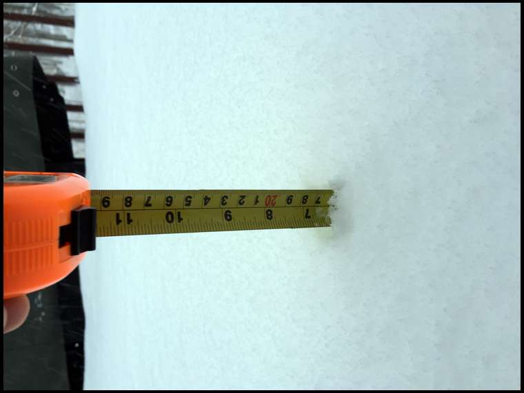
The total for the storm here in Seeley is 14" as of 6 AM Monday.
Smokey - I'm guessing that's about what we had here too. I didn't measure how much we got, nor do I care anymore. I'm just sick sick of this white crap. I'm not moving another flake of snow this winter. Better days ahead by the end of the week, maybe in the 50's.
More on the way Tuesday afternoon. The good news is, only 61 days till they start getting shorter.
we must have gotten 20" in Wausau which makes about 40"+ in the last 3 weeks? This was the most snow I've seen since the 1991 storm the last Friday of gun season
20 inches east of black river. I will be in my snowshoes for my bird hunt. This will be one I will probably remember for a lifetime.
i live by granton in clark county and on the 10pm news they reported granton got 23 inches........today's noon news the next closest town reported 17 inches......so yeah
Snow Reports Location Amount Time/Date
...Wisconsin...
...Brown County... Suamico 25.5 in 0700 AM 04/16 NWS Green Bay 24.2 in 0700 AM 04/16 Ashwaubenon 23.7 in 0100 AM 04/16 Allouez 22.0 in 0700 AM 04/16 2 SSW Allouez 19.8 in 0645 AM 04/16 Wrightstown 16.3 in 0700 AM 04/16
...Calumet County... Darboy 3 SE 15.2 in 0700 AM 04/16 Chilton 11.5 in 0800 AM 04/16
...Door County... Carlsville 2 NW 31.6 in 0630 AM 04/16 Ephraim 1 NE - WWTP 25.0 in 0700 AM 04/16 2 WNW Baileys Harbor 24.8 in 0700 AM 04/16 Sister Bay 20.5 in 0800 AM 04/16 Sister Bay 1 N 20.5 in 0700 AM 04/16 Forestville 4 E 20.2 in 0800 AM 04/16 Baileys Harbor 3 ENE 18.2 in 0700 AM 04/16
...Florence County... Spread Eagle 1 NW 18.0 in 0700 AM 04/16 Aurora 14.1 in 0730 AM 04/16 1 NW Spread Eagle 13.0 in 0700 AM 04/16
...Forest County... Argonne 1.5 NW 14.1 in 0720 AM 04/16
...Kewaunee County... Kewaunee 18.5 in 0700 AM 04/16
...Langlade County... White Lake 1 SE 20.1 in 0800 AM 04/16 Summit Lake 17.4 in 0630 AM 04/16
...Lincoln County... 3 WSW Bradley 19.2 in 0700 AM 04/16 Merrill 7 W 18.5 in 0600 AM 04/16 Merrill 8 W 18.5 in 0600 AM 04/16 Rice Reservoir No. 2 15.2 in 0700 AM 04/16
...Manitowoc County... Two Rivers 11.0 in 0700 AM 04/16
...Marathon County... Weston 20.5 in 0800 AM 04/16 Wausau WSAW TV 20.5 in 1145 PM 04/15 Schofield 20.0 in 0500 AM 04/16 Wausau-Northeast 17.1 in 0530 AM 04/16 Eau Pleine Tender 16.0 in 0700 AM 04/16 Spencer - Wwtp 12.9 in 0730 AM 04/16
...Marinette County... Peshtigo 27.5 in 0730 AM 04/16 Athelstane 13.0 in 0600 AM 04/16 Crivitz High Falls 11.4 in 0800 AM 04/16
...Oconto County... Stiles 1 S 30.5 in 0730 AM 04/16 Oconto 4 W 29.0 in 0700 AM 04/16 Pulaski - WWTP 28.0 in 0700 AM 04/16
...Oneida County... Mc Naughton 3 SSE 19.4 in 0700 AM 04/16 Hazelhurst 18.5 in 0700 AM 04/16 Rhinelander 18.4 in 0523 AM 04/16
...Outagamie County... Appleton 21.2 in 0700 AM 04/16 Appleton WHBY Radio 21.1 in 0800 AM 04/16 2 WSW Kimberly 19.0 in 0800 AM 04/16
...Portage County... Stevens Point 20.7 in 0730 AM 04/16 Plover 19.8 in 1223 AM 04/16 Rudolph 1 NNE 17.9 in 0530 AM 04/16 Almond 5 NE 15.7 in 0800 AM 04/16 3 NNW Junction City 14.5 in 0800 AM 04/16
...Shawano County... Tigerton 30.6 in 0852 AM 04/16 Shawano 2 SSW 29.8 in 0800 AM 04/16 Krakow 24.5 in 0800 AM 04/16
...Vilas County... Lac Du Flambeau 19.5 in 1011 AM 04/16 Eagle River 4 E 14.8 in 0627 AM 04/16 Eagle River - South 14.0 in 0630 AM 04/16 Land O Lakes 3 W 13.8 in 0730 AM 04/16 Boulder Junction 9 ENE 11.3 in 0710 AM 04/16
...Waupaca County... Waupaca 28.4 in 0800 AM 04/16 New London 28.3 in 0530 AM 04/16 Scandinavia 28.0 in 0800 AM 04/16
...Waushara County... Wild Rose 16.7 in 0700 AM 04/16 Wautoma Silver Lake Sanitary 11.9 in 0830 AM 04/16
...Winnebago County... Neenah 12.6 in 0700 AM 04/16 Omro 1 WSW 12.0 in 0700 AM 04/16 Omro 2 SW 12.0 in 0700 AM 04/16 Oshkosh-north 11.6 in 0700 AM 04/16
...Wood County... Nekoosa 20.2 in 0927 AM 04/16 Pittsville - WWTP 18.5 in 0700 AM 04/16 Wisconsin Rapids-Southeast 17.3 in 0730 AM 04/16 Port Edwards 2 E 15.8 in 0830 AM 04/16 Marshfield 12.0 in 0700 AM 04/16
Observations are collected from a variety of sources with varying equipment and exposures. We thank all volunteer weather observers for their dedication. Not all data listed are considered official.
Got lucky in Dunn Co. We got less that 10 inches for the whole weekend.
2013 was a rough spring also. I fired up a bear bait on May 1st.
May 2nd was a whole different story.
My cabin neighbor just confirmed. He's parked on the road. 4 ft high banks at end of driveway. Says no way a plow will touch it. Can't say as I've ever actually been snowed out of a Turkey hunt before. Have hunted in a snow storm or two, but not blizzard aftermath.
Rent a skid steer. Oh wait, is a turkey hunt really worth it?
Just got vehicle all the way to the road today after 1pm . Hundred feet to the garage with a freezer full of V ... not sure when I'll get there. I am not shoveling that. Drifts to the roof line. a car was completely buried and packed under, can't find the picnic table...
Once out noticed the county plows pushed it higher than the signs.
The tunnel I cut to the road scrapes the door handles as I pass.
You get the idea.
Northern Bayfield County update: Snow is melting fast, but in the woods its still a solid foot plus. Southern exposures are getting snow free. Open areas where the snow blew away are snow free. The ice in the Bay is still locked in hard. Still at least 2 feet average. Solid ice from Houghton Point to tip of long Island. Going due west NW from there to Bayfield, its flow and pack ice and that remains to La Pointe but the south channel between madeline and Long is open water. But there is still solid ice from Bayfield past Red Cliff and solid ice between Basswood and Madeline all the way to Stockton south end. Bad ice at the Souix and Onion Rivers-all pack/flow. Chequamegon Bay is flat white.
I put away all my snow clean up gear today. Feel free to blame me for anymore snow we get.
I headed up to Hayward today. Very little snow left south of Rice Lake. Rice Lake to Spooner there is some but still significant open areas. Hayward, a lot of the snow is gone but still some deeper spots scattered around but open areas also exist. With a lot of sunshine hours and 50 degree temps predicted the next 6 days most of what snow is left will not be here for long.
Road Kill bear on the shoulder of the road 25 miles south of Rice Lake. Dead turkey on the shoulder 10 miles north of Rice Lake. Several dead deer scattered along the way, some had probably been buried under snow for a while.
Snow cover on the lake looks wet across some large areas. Figure there is still plenty of ice under the slush. I will test it in the morning. Wish I had a 3' long drill bit. Might put a wet suit on just in case.
There was still 14+ inches in waupaca county this morning but melting fast
"I put away all my snow clean up gear today. Feel free to blame me for anymore snow we get."
I started tearing down both my plows yesterday. If we get more snow, I would have to hire someone to plow for me and my accounts.