OnX accuracy
General Topic
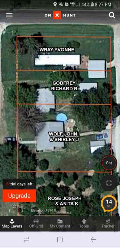
My brother just got the 7 day free trial to see if it's something he wanted. And right off the bat he looked up the house he is renting. He lives in the "Godfrey" house. It shows the property line going about 10ft into his house. And the neighbors garage about halfway on each side of the property line. I don't ask to be argumentative or talk bad about it. Just from reading about people using it in to mountains for hunting, I was under the impression that it would get you right down there within inches or a couple feet at most.
Sometimes its dead on, sometimes not.
For something like that, its only as good as the database layers they have access to from cities, counties, etc. The overlays in many counties are only an approximation.
My next door neighbor came to me a couple years ago with a similar shot and demanded that I compensate him because the aerial view showed half my garage on his property. Then he started moving the fence onto my property. I quickly got a surveyor out and shut him down- but not before he had built a stone and mortar pillar as a fence corner. Boy, was he pissed!
It's not accurate. I turned in a half dozen hunters and their guide in Colorado for trespassing a few weeks ago. They were convinced the U.S. Boundary was a mile away when it was only 500 yards. I personally walked up to it trailing a herd of elk. I argued with the guide but his hunters were already across the fence
Agree with Lou. I recently looked at my parents place and their home wasn’t even located on their 2 acres per OnX. In most hunting scenarios, it’s been really good and spot on with fence lines, etc.
Thornton, interested in what the warden said given most of them use the application.
Lou is correct. The problem is not necessarily with OnX. Satellite overlays don't always (usually?) correspond to actual GPS locations or surveys. That can be obvious in some situations (as in KsRancher's example). Out in the middle of nowhere, it may not be.
A lot (like ALL in WI) of counties don't have georeferenced property boundary layers so they can be anywhere from exactly correct to hundreds of feet off. All of these mapping apps get their layers from local governments so they have the same problem. They are a handy reference but need to used as just a guide.
If you know anyone who uses GIS programs you can get PDF maps from them that are georeferenced and used an app like Avenza maps to give you data that is as accurate as your gps. Still not perfect but close enough for most situations.
Considering that many fish and game department officers have access and use the exact same overlays, I would say it’s a good as you will get at this time.
I've never had an issue with it where I live or where I hunt in various places around Colorado and Wyoming, and I've double-checked it against fence lines and property pins. Like Lou said above, if the county overlay is not good then OnX will be off too, it's not the fault of the OnX guys. Thornton, I'd love to hear how your experience shook out because it sounds more like those guys couldn't read a map, I'd seriously doubt than even bad county data would put the property lines that far off.
Inches? I’ve never seen a GPS good to inches.
I wish it worked in Canada.
My experience with OnX is that I will not be renewing. I'll be trying something else.
Have him use a different app and see if its the same boundaries. I'm headed to one of the most checkerboard units in Colorado tomorrow and I feel pretty confident with OnX. I have found tons of mismarked private land there and had the Game Warden come out and verify it. Wish they were a little harder on people who put "No Trespassing" signs on public.
I've found it to be very accurate where I use it in Colorado. Verified by actual survey monuments in several places.
USFS and BLM layers are more accurate than county overlays.
Some places are accurate. Some are not. The only way to know for sure is know how well the county assessor and or surveyor has done in the past putting the info together. Of course, if the info they have is flawed, lacking, etc..., it will be flawed too.
Most guys do not understand this. But, most county office's country wide has spec print books with every landowner in the county and their parcel drew out on it. But, many of those maps are simple drawings of a boundary plotted on paper and pieced together to represent each parcel. Unless a surveyor has mapped each one of those parcels and put them to exact scale and, referenced it with on the ground known boundary's, they can only be so correct across a broad scale. They are not the Gospel by any means. And, every company uses the same info because no one has the money or resources to do it any better.
In open flatter country these applications are pretty much dead on. Because it allows a surveyor to truly line things up when creating the maps and, allows them to scale their map to the aerial maps known scale. Fences are obvious, roads, ridge lines, high points, etc.... are all easy to identify and are often used in surveys as boundary markers. Out side that, its a guide line at best. And would take a real on ground survey to verify for accuracy. So, while it might be the best we have and, should be used with that in mind, it can be very much wrong. By a big amount sometimes.
These programs have made instant surveyors out of people that couldn't even set up a compass to run a bearing. It has also empowered a lot of unknowing people to be experts on property boundary's if law enforcement is using it to enforce their laws. I don't know what to say other then that. Use caution and common sense. And hope that everyone involves does the same
Lou is 100% correct as well.