It is worth the money if you hunt any of the walk-in areas. Walk in over lay is much better crappy pamphlets put out by the state.
I have it on my iPhone X and on my iPad
The Off Grid option is the real deal
I do not have it on my GPS
Good write up Pat.
Good luck, Robb
OnX is a game changer.
Hopefully, someday, the imagery will be as good offline as it is online.
If you try to load too many off grid maps, you will will crash it and have to clear all the chached data. Then you are starting from scratch. This caused me some major grief as I had to dump the maps from one hunt and load new maps for the next hunt as I was traveling in between with crappy cell service.
As an individual who spends a tremendous amount of time off-trail in the mountains, as well as someone who scouts year-round, a GPS is tremendously valuable to me. The phone GPS apps were truly a game changer for me and have added tremendously to my experiences.
I've used Gaia, OnX, and a few other GPS apps. My clear take-away is that Gaia is head and shoulders above the rest. OnX is aggressively targeted toward hunters but Gaia is superior in ever way that I've found. My buddy swears by OnX and is always showing me this and that on it...but Gaia does all of those things and more. My recommendation to anyone considering purchasing OnX is review the several excellent threads here on Bowsite discussing and comparing the two, look at the price-points (overall), and give the free trials of both a go. I have a Gaia Premium subscription and certainly see myself continuing to renew each year.
I need my offline maps, all of them, to show up seamlessly when in the field. I drove the quad 9-12 miles to get to a hunt location, on every hunt in Wyoming. Using the phone for guidance, I can't be picking maps as I go. OnX allowed us to just drive. That feature was the deal killer for competitor brand B.
When it comes to reliability I've found that Gaia beats OnX badly. I really liked the OnX when I used it for three years. But, I was frustrated too many times with the maps disappearing. The Gaia maps have loaded up faster and have been more dependable for three hunts this year. I'm not familiar with all of the features of either but Gaia or OnX but I have been very happy with the Gaia app so far.
After watching Pat's video it looks like OnX added some useful features this year. My experience with using both in airplane mode has been that OnX used more battery than Gaia. It is great for us hunters to have some great choices for the mapping/navigation apps. Either app will do what you need it to do.
My only real issue with OnX was when I am in Offline mode - it would take me off of that mode 5-6 times a day and then ask if I wanted to resume tracking. Sometimes it would completely stop the app so there are some bugs in the program.
I will check the Gaia program - if it has as good display, then I probably go with it. Most of the places I hunt are in wilderness or NF areas so the private land feature just wasn't utilized.
I had to figure out a way to recharge my phone in a wall tent because I basically would discharge the phone in one day.
And, I know - all of these complaints are first world problems...
And GAIA is much much cheaper..
Again,,,, it is a GOOD tool but it is only as good as the county or state GIS data base. Land open to to public can close at the stroke of a pen and may not show up the change for months. Be careful. Do your home work.
My only problem was the first phone that I had it in couldn't deal with more than a few stored maps for offline use and I didn't have unlimited data at the time which made wifi a necessity for downloading maps. My only complaint was when they did a major update in 17 right before the start of Western big game seasons and a lot of folks apps and data was going haywire (mine did not). That was poor planning.
I use it offline more often than not. Offline use is a simple process of saving maps of the area you plan to hunt and operating offline. I save maps in the 10 mile resolution(middle selection) and have all the map detail that I could possibly need. I can find pheasant cover with it, so not sure how much more I'd need. I guess if you are looking for rubs, then yeah, it may not be high enough resolution. I mainly use it for staying within boundaries of Block Management and other broken up public land. I do use it to mark locations, measure distance, some scouting while I'm hunting, etc.
Features that I really like: Hunt District boundaries Updated Block Management maps, Links to FWP info like hunt district rules, individual block management rules, etc. The map scrolls seamlessly online or offline, provided you've saved your maps for offline.
I'm not familiar with Gaia except for a short look at their website, and first look didn't have me thinking "hunting app". I'd have to do more research.
I used OnX on my phone for the first time this year while hunting Wyoming, Wisconsin and Kansas. I’m very impressed with it and I’ll continue to use it in the future. I didn’t think anything would replace my handheld GPS but OnX has come very close. I still used my GPS quite a bit in Wyoming but in Wisconsin and Kansas where the property line and public hunting access layers were more important, I don’t think I turned my GPS one time other than to navigate to some previously marked waypoints that I had not yet uploaded into OnX.
One thing I’d like to comment on is the perceived accuracy of the property line data on the app. I’m a Licensed Land Surveyor and a County Surveyor who also oversees the maintenance and publishing of our County GIS parcel map information so this subject is right in my wheelhouse.
GIS parcel map databases are created by taking the legal description of all parcels of land in the county (usually just the description used on real estate tax statements rather than the actual recorded deeds) and drafting them electronically and creating a seamless map of the entire county showing all parcels of land.
To the best of my knowledge, the GIS parcel data used as the basis of the property lines in the OnX app is data produced by various units of government such as city, county, state, federal, etc. and is most likely obtained free of charge or for a very minimal fee and then assembled into a seamless map.
The accuracy of the parcel data in any given area on OnX is only as accurate as the data produced by the specific governmental unit.
In some areas of the country all of the United States Public Land Survey corners (section corners) were surveyed and accurate survey grade coordinates were established on those corners prior to creation of the local GIS parcel map. The section corners then serve as the framework upon which the GIS parcel map database is built. In those situations, the GIS parcel map should be relatively accurate, although it is still not an actual survey. As a rule of thumb, anytime a County Surveyor (or some other Land Surveyor) is involved with the creation of the GIS parcel map and the GIS is based on the location of the actual section corners, the GIS will be relatively accurate.
On the other hand, restoring, surveying and establishing accurate coordinates on all of the section corners in a county is a very expensive and time consuming task. In many counties the need for a GIS parcel map database was great enough that they couldn’t wait for all of the section corners to be restored and surveyed (which could take years or even decades). Some states had statewide initiatives to map the entire state with a modern GIS regardless of the status of the section corner monuments and coordinates. In those instances the creation of the GIS parcel database sometimes forged ahead without the benefit of using the section corner framework as the basis of their GIS and with little or no input from a land surveyor. Some GIS mapping professionals also believe that accurate section corner coordinate data is not necessary in order to create their database. This has been a long standing debate amongst Land Surveyors and GIS professionals. Surveyors say that “GIS” stands for “Get It Surveyed”.
When a GIS parcel database is not based on accurate section corner coordinates it has to be based on something else. This could be a wide variety of things including the location of the section corners as depicted on USGS topo quadrangle maps and a lot of assumptions (some of them inaccurate) could be made. The corner positions shown on USGS quad maps could be off by hundreds of feet and therefore the GIS will be off and so will OnX.
Another issue that factors into the accuracy of GIS and OnX is the actual distances between section corners vs. the assumed distances used in some GIS databases. A section of land was intended to be 1 mile square (5280’ x 5280’). However, in reality there is no such thing as a section that is actually 5280’ long, or a quarter section that is exactly 2640’ long or a 1/4-1/4 section (“40”) that is exactly 1320’ long. Therefore there is no such thing as a section that contains exactly 640 acres, a quarter section that contains 160 acres or a 1/4-1/4 section that contains 40 acres. In many areas of the country the original government land survey was performed in the early to mid-1800’s. The measurement technology was crude by today’s standards and the conditions were often brutal. Corner posts were set in the ground as accurately as possible. The corner posts are deemed correct regardless of the fact that modern more precise measurements might show that the half mile and mile distances are off by 5, 10, 20, 30 feet or more. Most measurement errors that occurred in setting the original corner posts resulted in the distances between the corners being short when measured with modern survey equipment such as Electronic Distance Meters (EDM) and survey grade GPS receivers with sub-centimeter accuracy. Therefore, typically when you buy a “40” you are actually buying a 1/4-1/4 section and it is extremely unlikely that it would contain exactly 40 acres because the 1/4-1/4 section is a proportionate fraction of the section and if the length of the sides of the section are short then every other fractional part (aliquot part) of the section will also be short.
Why am I going to all of this detail…? Because many GIS databases that are not based on accurate coordinates on the actual section corners or the actual distances between the section corner posts. But rather, they assume that every mile is exactly 5280’ feet long and therefore they assume that every quarter section is 2640’ x 2640’ and every quarter-quarter section (“40”) is 1320’ x 1320’. It’s possible that an actual section could be 50 or more feet short but when the creators of the GIS draft their map they assume that the section is exactly 5280’ long and they have to try to fit that section and the aerial photo into the database when there may only be 5230’ on the ground to work with. Furthermore, since they don’t have actual coordinates for the corner posts in the ground, they have to make a lot of assumptions/guesses as to where the actual section corners are because every legal description of every parcel of land is dependent upon the location of the section corner posts. You can’t accurately draw a parcel of land on a map if you don’t know where the corners are that control the location of that parcel of land. Now try to do that across an entire county with hundreds of sections, thousands of section corners and thousands of parcels of land and you can see that there could be a lot of fudging, guessing and rubber-sheeting going on. None of which helps the accuracy of the map.
Then there are the states that comprise the original 13 Colonial States and other areas which were not surveyed under the United States Public Land Survey rectangular survey system. I don’t know what they use as the basis of their GIS and I can’t speak to its accuracy.
GIS parcel maps were mainly intended as a County Assessor’s database used to aid in the collection of real estate taxes. GIS parcel map databases were never intended to be the basis of an accurate land survey or the basis of a phone app used by hunters to determine the location of property lines. Therefore, regardless of their inherent inaccuracies most GIS parcel databases work very well as long as they are not used for a purpose other than what they were intended for and/or their limitations are understood.

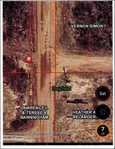
I own some property in Bayfield County in northern Wisconsin. Bayfield County has an awesome award winning GIS. However, their GIS is not based on the location of the actual section corner monuments.
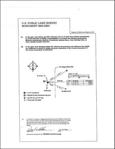
This document is what surveyors call the “tie sheet” for one of the corners needed to determine the location of my property lines. The corner monument is the solid dark symbol in the center and the other objects are the “ties” used to reset the corner monument if it should happen to get disturbed or destroyed. The tie sheet shows that the corner monument is on the extension of the centerline of Pratt Road to the east and 21 feet west of the centerline of Happy Hollow road.


One of my property corners is a “40” corner approximately a quarter mile east of this monument. In order to determine the location of that “40” corner I need to measure the distance from this monument to the next section corner monument approximately a half mile east and then split the distance in half and that will determine the length of the “40”.
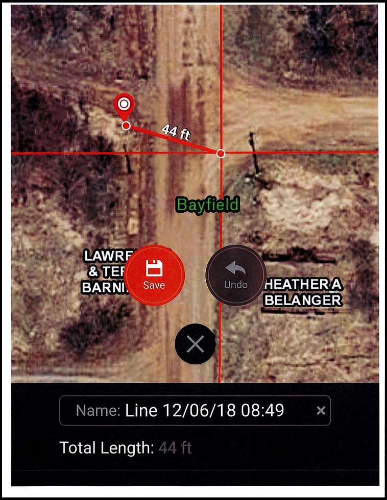
I checked the distance between those corners on the OnX app and on the Bayfield County GIS and the distance is exactly 2640 feet. I’ve actually measured that distance and I don’t remember off the top of my head what the distance is but I know that it is short of 2640 feet. Therefore the “40” distance will be less than 1320 feet. OnX shows the “40” corner/my property line at exactly 1320 feet east of their corner in the southeast portion of the road intersection (intersection of red lines).
There are at least 2 factors coming into play that affect the OnX location of my property lines. First, the corner position is off by about 44 feet and second, Bayfield County has assumed that the “half-mile” distance between corner monuments is exactly 2640 feet, which is not true in this instance or most likely in any instance. The end result is that OnX’s depiction of my property line could be off by 40 to 50 feet.
Ironically, I’m having a little dispute with my neighbor who recently had his property logged and then pounded in a row of big ugly blue steel fence posts based on ribbons that the loggers hung in the trees. The line of posts appear to be veering well into my property. Just my neighbor’s luck that his neighbor happens to be a land surveyor… ;^) Unfortunately OnX is not accurate enough to prove that my neighbor’s posts are not in the right location and it’s certainly not accurate enough to determine the location of a property line when you’re trying to get down to the gnat’s ass when hanging a tree stand next to a property line. I certainly wouldn’t rely on OnX as the basis of an argument with a landowner over the location of a property line.
I love OnX and this is in no way, shape or form intended to be criticism of OnX. I just figured that since I had some real world facts it might help to educate some users regarding accuracy.
Sorry this got so long.
I've a good friend that's a land surveyor in CO and this level of detail is how he'd try to find property corners when we hunted together. I've a little experience with it myself back when I could refer to myself as a young engineer. I've found the MT maps to be relatively accurate, not survey-grade accuracy, but accurate enough that I know where I can and can't hunt.
Greg
arrow1, I tend to agree with your comment but remember, a GIS is not intended to be an accurate survey but rather it is a graphical representation of various information. I believe the award it won was based on factors other than accuracy of property lines...
2018 I have hunted a lot of public land and my only remaining tag is a state land antlerless that is county specific. One piece of ground we hunt crosses county boundaries and I need to stay on the south side to be legal. OnX shows the boundary between the two DMU's and I give it about 50 yards extra at the minimum so I am not even close to violating my tag. It is the best tool I have used and again, I'm using the free download and not the paid version.
This year I used it for both deer and elk hunting in areas that were surrounded by private property. It was EXTREEMLY important to know where I was hunting considering the new trespassing laws in Idaho that allow zero leeway when crossing into private property. Property owners no longer need to post their property or give a warning.
I completely missed my only opportunity to shoot a deer and missed several opportunities to shoot an elk.
The app constantly locked up/froze. The only way to get it working was to restart my phone. Anybody that hunts knows that waiting 2-3 minutes often results in a missed opportunity. To make matters even worse (the reason I call the app "devastatingly horrible") when it locked up as I was moving along the road crossing between public and private property, I often thought I was on public land when I was actually on private land. Shooting an animal on private property could cost me my license, at the very least and I'm certain that Fish and Game would not even consider OnX locking up as a valid excuse.
My two brothers were having the same issues. Contacting technical support from a mountain top was not an option.
My buddy that runs it on iPhone seems to have less hiccups than my ANDROID platform.
I’m switching to Gaia. It can’t be worse. And the fact that OnX auto-renewed in the middle of the trip where I struggled most with it was salt in the wound. It’s too bad because I have really liked their product for quite a few years, but after this fall, it’s time to move on.
First off, I used it extensively in WY. It worked really well with off-line maps in a large block of National Forest. I wasn't concerned with property lines, just location and contour lines and marking points for me to get back to. I found it not as accurate as my GPS for getting back to a certain square foot of ground. But I found it plenty accurate enough to get me very very close to that square foot of ground. There were wilderness boundaries marked on it, but I'm not a guy that flirts with boundaries, and I didn't find it an issue for me.
Secondly, I use it sporadically to find stands in the dark on properties I hunt in Missouri. I'm a decent navigator in the dark, and usually don't need it, but every now and again I'll get slightly off-kilter in the dark and will use it to reorient myself to the stand.
Third, I used it pretty extensively in South Dakota to pheasant hunt. I was very pleased with the accuracy of the Walk-in areas and CREP areas. I know those places can change, but we didn't find a single property that was marked as public access in OnX, that didn't have actual physical public access signs on the property itself. I was a little surprised. I figured we would find at least a couple of places that were out of date. But we sure didn't. It was invaluable for finding new public places to look for pheasants.
And then we used it when we paid for some access to private ground. We paid for the access, and not for a guide. So the guy set us up by showing us what properties we could hunt on my OnX, then we had free rein. It was handy there too. We knew what property we had access to and where it went and how big, etc. Very handy to plan how we wanted to hunt certain things like fencerows or sloughs.
I'm very pleased after my first year of using it extensively.

