Hunting Apps and property lines… ?
General Topic
What’s the plus/minus in feet/yards of property lines generated by apps, in your opinion? Example: north side of our property has fences, but by the app service (huntstand), there’s one fence that looks to be constructed 50-75 yards on our side. What do you think of accuracy of these apps… (OnX, huntstand, etc)?
Ive seen them waaaay off - and also seen them pretty close
I have found some are right on the money and some have been 20 yards off.If you think one is off on land you own check your state laws as some say after so many years with live stock it becomes line.Or you may want to have surveyed.I have had fences built inside the line due to a hedge row but we always file a legal paper with register of deeds saying the fence was built in convenience and shall not be considered a property line.
I just checked a new property in SC with OnX two weeks ago. I walked it while marking corner posts. Amazingly accurate within mere feet on all of them. Never used huntstand tho.
I could be wrong but the app itself has nothing to do with the accuracy. It's the accuracy of your phones internal GPS
The aerial photos and property lines are base layers and not dependent on GPS. Your location on the base layers is dependent on the accuracy and signal (number of satellites) of the GPS.
Their accuracy is limited to the accuracy of the maps they used, which are usually whatever boundary maps are on file with the county. Not every property has a recent survey on file. Some are just rough estimates, others are highly accurate.
I was able to find all my corner pins on my property using OnX, but I had it surveyed when I bought my place, so the county plat map was accurate. I also found that one of my fence lines is about 75 yards off in my neighbors favor. We agreed to leave it as is, because it wasn't worth the expense and labor to move it.
Matt
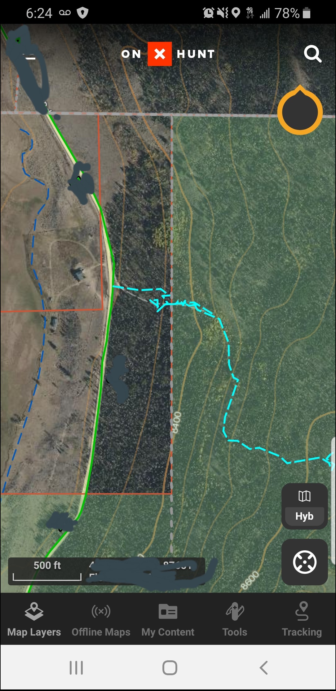
Habitat, I think you are on to something. I feel it was a convenience factor due to it being an edge of field/trees and that the folks to the north run cattle. So, they “conveniently” fenced over on our side, without a true legal survey. The other lines match up to within feet, including two corners. The stretch that was fenced on our side runs E/W about 3/8 of a mile. Again, clearly 50-75 yards on our side.
All those apps do the same basic thing, they pull in whatever they can from public records, tax maps, plat maps etc. The accuracy of the lines is up to the accuracy of those maps. They pull those maps, then images from places like google earth and overlay them
Then add the accuracy of your phones GPS to show where you are on that map.
The apps are only as good as their data sources. As mentioned above, this is likely county GIS. Some states/counties update their GIS info. Others cannot spell GIS.
I use OnX all the time and have been very happy with the accuracy.
Just make sure that’s clear in the event that either of you should choose to sell. I had no direct stake in the outcome, but I’ve seen that show before. More than once.
Around here, I’d be asking a lawyer what needs to be done to get a lock on what’s rightfully yours, because a Neighborly Agreement is only valid as long as both parties are interested in being Neighborly and Agreeable… I know one guy who owned some property in upstate NY who basically lost it to some squatters. I guess it would have cost more than the land value to fight it out in court, and he decided it wasn’t worth fighting out any other way, either… although I’m certain he would know how.
I guess I wouldn’t sweat the accuracy myself, because unless you’re using some skinny little easement it really needn’t much come up.
Just doesn’t seem smart to me to be operating within death-run distance of a property line in the first place, so 10-15 yards +/- seems pretty trivial.
And out here, the state marks the borders of their lands.
Little bits of Private here are trickier; when I did have access, it was a big enough parcel to stay well clear of the edges, and of course we have an abundance of pre-revolutionary stone walls to work with.
The accuracy of county overlays is what is most important, generally. It shows my house to be roughly 100 yards inside public land on OnX. My phone GPS is right on the money. All of the property lines around me are way off according to OnX, because of the overlays. I would never trust OnX in a true property boundary dispute.
This one is one of my favorites. It appears that my track crosses a significant portion of private land to reach National Forest. Nope. That "private" is all NF, which I confirmed with the NF office and the adjacent property owner. The cool thing is that my track is the only viable way to access that whole mountain, because where the NF is shown to touch the road is an impenetrable jungle of deadfall.
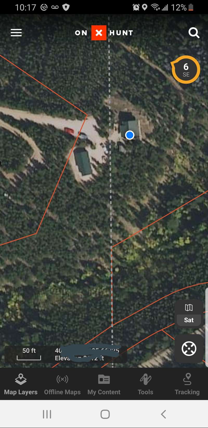
Heres my house where I am right now. GPS shows me in the house. The alleged property line shown on OnX is on the left, just to the left of the garage. It should actually be about 100 yards past the house, to the right.
Lou - that entire area is off, based on the county data. I noticed that when I was up there at MattD's place.
Yep, sure is. Most of the county is. My garage in town is shown to be on the next door neighbor's property. The previous owner tried to get me to pay him for my garage based upon a printout of the overlay he got from the county. I had to pay for a survey to prove him wrong. Which is why I am very careful when navigating private property lines anywhere using phone apps.
Thanks guys! I only ask because a guy that used to hunt with us noted this when out scouting last year. Then, I went out in September and walked this area out and was able to verify the distance the fence was over on our side. The only thing that pissed me off was the people to the north had stands, in trees, RIGHT on this fence. We always stay off of the fence at least 100 yards or so.
Anyways, you guys answered my questions. Not gonna concern myself much with at this point because it’s a landowner issue and I lease this land for hunting. For the record, the adjoining landowner and myself had a conversation about people coming over on us and he couldn’t provide names of the people hunting on him. He’s a local DA. :)
On x uses the data from each county's GIS, and not the actual plats at the courthouse. Every county's GIS has a disclaimer about use when you access it. Accuracy depends on the GIS technician that converted the plats, among other things. Even official state GIS systems, such as Wyoming's hunt planner, can have errors in hunt area borders and one has to follow the written description in the regulations digest and not the GIS.