Mathews Inc.
GPS for a dummy
Equipment
Contributors to this thread:
KsRancher 28-Jun-18
Ucsdryder 28-Jun-18
KsRancher 28-Jun-18
Charlie Rehor 28-Jun-18
wyobullshooter 28-Jun-18
Ucsdryder 28-Jun-18
cnelk 28-Jun-18
midwest 28-Jun-18
jdee 28-Jun-18
Bou'bound 29-Jun-18
BULELK1 29-Jun-18
pav 29-Jun-18
carcus 29-Jun-18
BOHUNTER09 29-Jun-18
Franzen 29-Jun-18
Muddyboots 29-Jun-18
Pyrannah 29-Jun-18
Cheesehead Mike 29-Jun-18
Zim1 29-Jun-18
Inshart 29-Jun-18
LKH 29-Jun-18
Bake 29-Jun-18
KsRancher 29-Jun-18
Cheesehead Mike 03-Jul-18
midwest 03-Jul-18
Rut Nut 03-Jul-18
Reflex 03-Jul-18
Bowfreak 03-Jul-18
Cheesehead Mike 03-Jul-18
Buffalo1 03-Jul-18
Lovehunt11 03-Jul-18
Whocares 03-Jul-18
Rut Nut 05-Jul-18
midwest 05-Jul-18
Cheesehead Mike 05-Jul-18
Shug 05-Jul-18
Mild Bill 05-Jul-18
Mild Bill 11-Jul-18
From: KsRancher
28-Jun-18
Wanting input on a GPS. My dad and I got one the first year we went elk hunting and it was disastrous (cause I didn't know how to operate it) the directions were off by 90 degrees. So we just havent used one anymore. Don't want one with a lot of fancy stuff. Just need to be able to find the truck, camp site, and hopefully kill site. We are going to camp in a different location this year and hunt another few drainages that we aren't as familiar with. Just need to be able to find them in dark is all we are conerned with. So the simpler the better. Thanks for any input

From: Ucsdryder
28-Jun-18
YouTube. There are probably a 100 tutorials and they’ll be easier to follow than a written explanation.

From: KsRancher
28-Jun-18
Sorry for the poor explanation. I am wanting input on a brand and model of a unit to buy. Don't even have the one I bought 6 yrs ago.

28-Jun-18
I use the Bushnell Backtrack. It marks five spots. I mark my truck then Hunt then return to truck. Easy Peasy.

I do use a regular GPS as well.

28-Jun-18
Garmin etrex. Around $100 and it’ll do everything you’re looking for. I’ve been using one for many, many years. It’s as simple, easy and user-friendly as they come

From: Ucsdryder
28-Jun-18
I have a garmin 64. Pretty idiot proof honestly. I’d still recommend watching some YouTube videos and see which look best. You need to decide if you want the touch screen or not.

From: cnelk
28-Jun-18
Hell I still use my old Garmin 12XL in my boat. That thing is bullet proof and super easy. Had it going on 20 years. Less than $100 online.

But my newer Garmin 62st is easy too.

From: midwest
28-Jun-18
wyobullshooter x2. I've used my little yellow etrex for years and have no desire for something with maps unless I'm negotiating private land. I can input a waypoint to a spot I've never been before using my topo map and find my way there the next morning in the dark.

I will be trying a phone app this year for the first time but my etrex will be in my pack with my truck location marked before I head out.

From: jdee
28-Jun-18
A lot of guys are using GIAI app on their phone and love it. I'm using a Garmin Oregon 650T and if you can use a smart phone you can use an Oregon 650T.

From: Bou'bound
29-Jun-18
garmin oregon

From: BULELK1
29-Jun-18
I am still using my Garmin 60x.

Once ya get to know your unit of choice you will keep it for years and years.

Good luck, Robb

From: pav
29-Jun-18
wyobullshooter X3! I've owned the basic yellow Garmin Etrex for years. "Upgraded" to a Garmin Colorado a few years ago...but found out I much prefer the simplicity of the basic Etrex unit! (Like midwest, I do plan to experiment with a phone app this year too....but my Etrex will be in the pack.)

From: carcus
29-Jun-18
My good buddy showed up with a magellan gps on his last elk hunt with me, what a POS, he has a garmin now

From: BOHUNTER09
29-Jun-18
I have had an Etrex for years. Never fails and simple to use. I may try Onx this fall since the area in Colorado has a mix of private/public ground

From: Franzen
29-Jun-18
Charlie's advice is spot on. The Backtrack is exactly what you are looking for. It's basically a backup for me if I actually wind up lost or if conditions are such that I don't have the ability to navigate otherwise (complete darkness, heavy fog, etc.). Every once in a while I get it out to make sure it is working with confirmation on my headings.

From: Muddyboots
29-Jun-18
Another vote for a Garmin etrex- simple and dependable, no bells and whistles.

From: Pyrannah
29-Jun-18
the gaia on your phone has been real simple to use.. you may want to check it and ONX out...

I run that with my garmin as a backup..

good luck man

29-Jun-18
I use GPS a lot too. I have an older Etrex but I don't really like the buttons on the side. I don't think they're as easy to use as the other Garmins with the buttons on the front.

One option would be to go on eBay and buy a used Garmin 12 or a Garmin 60 (the yellow one). I have a bunch of GPS receivers including a Garmin 12, two Garmin 60's and a Garmin 64st. A Garmin 12 is easy to use and will do everything you want, it's just slower at acquiring a fix than the newer and more complex/expensive models like the 64st.

From: Zim1
29-Jun-18
Second on Robb's Garmin 60csx mention. The st replaced it but the csx is simpler, easier & cheaper. There's no need for anyone to spend $400 for the st or other new units, when there's tons of used units available on ebay for $100. Many of them are in virtually new condition. Lots of options for $100.

From: Inshart
29-Jun-18
Purchased my Garmin 12 in about 1994, simple to use and reliable. Friend was getting rid of his - I now have a spare.

From: LKH
29-Jun-18
If you aren't, get familiar with latitude/longtitude before starting. Take it out and use it around town. I got a kick out of your story. Thought you might be my brother. He showed up with a new one and couldn't even store a waypoint.

You probably did what's really common and generally useless, show up in the woods without any idea of how to use it.

From: Bake
29-Jun-18
I have a Garmin 62st. Pretty easy really. I don’t get too involved in using it. I mark camp, and points of interest like wallows or kill sites. I also use it to mark all my tree stand spots at home. Very handy for finding trees in the dark without any stumbling around.

From: KsRancher
29-Jun-18
Thanks guys. I will take a look at the ones metioned. And just so everyone knows, I am not worried about getting lost. After I typed that post. I got to thinking. Everyone probably thought. "Man, if that guy can't use a GPS he shouldn't be up in the mountains". I am not scared to stay the night away from camp of I couldn't find it in the dark. But I figured it would be much more comfortable to sleep in my tent than to sleep under a pine tree at 10,500ft

03-Jul-18
I would suggest that anybody using a GPS change the readout from Latitude and Longitude to UTM which is much easier to relate to on the ground.

UTM is a grid that has been laid over the earths surface and it's much easier to understand than Lat & Long which is an angular measurement in Degrees, minute and seconds or Degrees and fractions of a degree.

Most topo maps have the UTM grid on them or little tic marks on the edges showing the grid and with that grid you can actually plot or estimate your location on the map using the UTM coordinates. With a little knowledge you can easily scale the coordinates of a feature on the map and input those coordinates into your GPS so you can navigate to it. Or you can read the coordinates of your location in the GPS and be able to determine exactly where you are on the map.

From: midwest
03-Jul-18
+1 Mike.....UTM is much, much easier to read. So easy to point to a spot on the map and input into your GPS.

From: Rut Nut
03-Jul-18
Cheesehead- how do you change from Lat/Long to UTM?

03-Jul-18
agree with the comments on UTM. you also need to understand that maps are all different too...without the correct map datum in your unit, you will be way off where you think you are on the map. In other words the map datum you GPS is using needs to match the map datum used in creating your map.

From: Reflex
03-Jul-18
For the few of you that said you were using the Garmin Oregon, how do you deal with the horrendous battery life? It seems like if I turn mine on for an hour while I mark a few spots on a hike it will be dead.

From: Bowfreak
03-Jul-18
Turn the screen brightness all the way down and it will last quite a while.

03-Jul-18

Cheesehead Mike's embedded Photo
Yep, go into your map setup or maybe it's in "Units". The default is Lat/Long and you can change it to UTM.

And yes, Straight Arrow makes a very good point about the datum. The default datum on your GPS should be WGS84 unless somebody changed it.

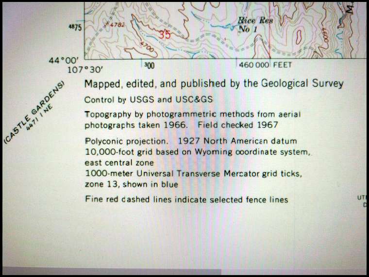
You should look at the map you're using and there should be some info about the datum. On a USGS 7.5 minute topo quad it's usually in the lower left corner of the map such as my example.

There's a bunch of gibberish about the datum and coordinates systems. This map says it's on the 1927 North American datum which is NAD27 CONUS in your GPS receiver. CONUS stands for Continental United States. You'll see many other options for NAD27 in other parts of the world but you want CONUS assuming your in the continental United States.

If your GPS is set to WGS84 and you try to plot the coordinates onto a NAD27 map or scale coordinates off of the map and input them into your GPS, you will be at least 200 meters off and possibly more because the two different datums are not compatible with each other.

If your map says it's on NAD83 you can leave your GPS set to WGS84 because the difference is so small you'll never see the difference.

The information on my example map that says the "1000-meter Universal Transverse Mercator grid ticks zone 13, shown in blue" is the UTM info I was referring to.

Along the left edge of the map next to the blue ticks are the numbers 4875, 4876, 4877, etc. Multiply those numbers by 1000 so they're actually 4,875,000 & 4,876,000 & 4,877,000 etc. Those numbers indicate the number of meters. There will be matching grid ticks along the right edge of the map and you can use a straight edge to draw a pencil line across the map connecting the grid ticks. Those lines will be the grid lines for your Northing coordinates. Some maps already have the grid lines drawn in.

Along the bottom edge of the map there are blue grid ticks with the numbers 300, 301 (301 is missing but the tick mark is just left of the word "FEET"), 302, 303 (also missing but right at the " on the 27'30"). Again, multiply these number by 1000 so they're actually 300,000 & 301,000 & 302,000 so on and so forth.

Again, draw a straight line between these grid ticks and the matching ticks along the top edge of the map. These lines will be the grid lines for your Easting coordinates.

Now that you have your grid drawn on your map with 1000 meters between each grid line you'll be able to estimate your position within that grid based on reading the coordinates on your GPS. The Easting is displayed first, Northing second in the GPS readout.

So now you can look at your UTM GPS coordinates as linear measurements along the surface of the earth rather than trying to convert lat/long to a linear measurement which is difficult because it is an angular measurement as if you were at the center of the earth and the coordinate is the angle subtended between the equator toward the north or south pole for latitude or between the meridians for longitude, etc. And by the way, the distance covered by one degree of longitude is the greatest at the equator and becomes less and less as you get closer to the north and south poles because the meridians converge much like the edges of an orange slice.

Translation... UTM is much easier. :^)

I made a clear plastic overlay that further divides the 1000 meter grid squares into a 100 meter grid. So if I want to figure out the coordinate of something like a small water hole, etc. I lay the clear plastic grid on the map and I can estimate the coordinates down to about 10 meters or less. I can then enter those coordinates into my GPS and navigate directly to the water hole, etc. Or if I want to plot the exact location of something on the map like a dead bull, I read the coordinates off of my GPS and use the grid to plot the dead bull on the map. Once I do that, I study the map and pick my best route to pack the meat out while avoiding steep terrain. I can also scale the coordinates off of the map of the route I want to walk and make waypoints along the route. Then I can confidently navigate along that route to those waypoints, even in the dark if necessary and I know that I'm not going to accidently stumble into a cliff or take a wrong turn.

Even without the additional clear overlay 100 meter grid that I made you can still estimate your position on the map fairly accurately using the 1000 meter grid you drew on the map. I only use the 100 meter overlay if I want to get very precise.

Sorry for the long post but hopefully it helps somebody...

From: Buffalo1
03-Jul-18
I use a Bushnell Backtracker. It has 3 waypoints. If I were upgrading, I would get the newer 5 waypoint model.

Very simple to use. It will get you from point B back to Point A if you are just moving around. I you have waypoints set it will get you from where you are to the desired waypoint. . May have to go through hell and high water, but you will get to your desired location.

03-Jul-18
Very good lesson from you Cheesehead ( Mike ). Thanks

From: Whocares
03-Jul-18
Reflex, I've been using an Oregon 450T for years and batteries last almost all September, Never been a problem. Don't leave it on all day either. Use lithium batteries. Have the OnX chip in it too. Great unit.

From: Rut Nut
05-Jul-18
THANKS for the tutorial, Mike! GREAT INFO!!!!!!!!!!!!!!

I spent probably 5-6 hrs reading the owners manual when I got my Oregon unit. But just learned the basics. Mainly just marking waypoints and navigating back to them. I really need to invest more time into it to find out what it can really do(to get the most out of it).

Your info will help greatly! Thanks again!

From: midwest
05-Jul-18
I do exactly as Mike does with the exception he marks a LOT more dead bulls than I do. :-)

05-Jul-18
Once you can pick a spot on a map and go there, or wander somewhere and then pinpoint your location on the map you are set free. If you are not using it with a map....then none of the stuff the cheesehead posts means anything.

05-Jul-18
You're welcome guys, I'm glad my info helps.

And yes, Straight Arrow is correct. If you're just using your GPS and you're not using a paper map, none of the information about the datum matters.

However, learning the capabilities of your GPS and how it can help you navigate can turn it into a very useful tool

From: Shug
05-Jul-18
I have the lowrance endura safari... and I’ll testify first hand any moron can use them

From: Mild Bill
05-Jul-18
Thanks for the heads-up on the Bushnell Backtrack units. I did some searching and just ended up ordering the Bushnell 360610 BackTrack Fishtrack on eBay for about $44 all in. This has 25 waypoints along with some weather related data. Bushnell has a Youtube ad for this unit; looks like it was introduced about 4 years ago.

From: Mild Bill
11-Jul-18
I've received the Bushnell Fishtrack unit. It is easy to use for up to 25 saved locations. Not only will it be good for finding your way back to the truck, it will be useful for finding the tree stand you just hung or an animal you're going back to drag out.

It also gives barometric pressure and whether it is rising or falling, temperature, moon phase and moon rise/set times, and time. They probably should have called it the Sportsmen Track instead of Fishtrack because it's good for anyone enjoying the great outdoors.

https://www.ebay.com/itm/Bushnell-BackTrack-Fishtrack-GPS-Weather-Resistant-Fish-Finder-Digital-Compass/392016312166?epid=1179444223&hash=item5b45fe3766:g:AbIAAOSwUN9ay2lP:sc:ShippingMethodStandard!15626!US!-1

  • Sitka Gear