Contributors to this thread:
Anyone use this app and do you like it? Thanks
Like it very much for what i do
will it take me to marked areas like a GPS
I use it a bunch for everything I do from my own property, to blood trailing, finding camping spots in the summer, E-scouting, and yes of course on out of state hunts. The more I use it the more I learn about all the things I can do with it. I typically hunt enough different states to make the premium version worth it.
Yes, you can use it to direct you to a marked area. You make a waypoint, then click on it and choose “go to”. Will tell u a straight line distance and draw a line to it.
I really like it. There are others similar but I’ve found OnX to be the most user friendly.
The phone gps apps are all very handy. Each one has it's own learning curve. OnX is probably the easiest. It helps to use it a lot and not just when you are on a big hunt. Onx with a regular compass came in handy last month in Wyoming when we got "temporarily disoriented" one night. Without tracking enabled OnX can get you to any waypoint but on a straight line which may not be the safest route especially at night.
I would still never hunt anywhere without a regular magnetic compass that can be kept a safe distance from a bino harness using magnetic closures.
"compass that can be kept a safe distance from a bino harness using magnetic closures".
haha!! i recently learned the hard way on this one...... oops
I really like it. There are others similar but I’ve found OnX to be the most user friendly.
I love my OnX. Sadly, I have so many waypoints etc in there now that I cant afford to stop paying them! They got me for life.
I'll never use anything else, too many waypoints across the west and pheasant spots both local and in SD. I'm also hooked for life.
I really like OnX too and like a few others I'm addicted to the waypoint crack.
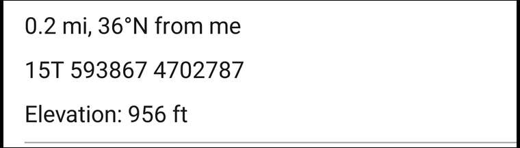
One thing I really wish is that instead of giving a general heading like "ENE" in SIP's photo, I sure wish it gave an azimuth or bearing in degrees such as 70° or N70°E. Those of us who still use a compass to help navigate would really appreciate it. That's one of the reasons I still use my Garmin GPS for more precise navigation. ARE YOU LISTENING ONX?
@sip is that a compass bearing? If so how did you get it up? I've looked for this and asked onx to no avail
@pryanna touch screen gloves too! Some gloves give off a magnetic field. Learned the hard way as well
I think the 61 in Sip's photo is the temperature although ENE could be 61 degrees. On my screen that circle is either Wind or Temp.
Yes to me it's absolutely worth the $ I don't use any of the hunting features. I mostly just use it to find out who owns land. I'm always looking for new hunting spots & especially when I see a field loaded with does I use the landowner info to locate & contact then I'll approach & inquir about possible herd control. This has worked for me over the years & especially considering I'm more concerned with a freezer full of venison than horns. It's a different way of approaching a landowner than just asking to hunt. More like offering a free service than just wanting to use their land to hunt.
Lost arra is dead on. It was the temperature
back up your data no matter who's app you use
just sayin...
One thing to realize about OnX is if you back up your waypoints on your computer or wherever and then you delete the waypoints off your phone, if you re-upload the waypoints to your phone any photos or detailed notes you attached to your waypoints will be lost. This has been frustrating for me because I like to take photos and make a lot of detailed notes about what tree stand trees are available near a certain waypoint what wind directions the stand favors etc. But OnX has a 1500 waypoint limit so I can't have all my waypoints from multiple states in my phone because I hit that limit. So I need to delete waypoints off of my phone at times and then just upload the waypoints I need for whatever state I'm going to. When I re-upload those waypoints all that extra detail that I included with the waypoints is gone.
GAIA doesn't have the data limit; partner switched just because of that.
If your a veteran give Onx a call directly, they really support their vets.
Click on a waypoint in Gaia and it gives you a bearing and coordinates. Mine is set to UTM.
As far as backups go.
Keep it simple. Excel spreadsheet, copy and paste coordinates from you waypoints to the spreadsheet with a simple footnote. At least for important waypoints/scout locations
@midwest. Onx does lack in that regard. I asked them to add it/update that feature. We will see. I only trust my phone/app GPS so much. Plus real compass is easier
So many more cool features on Gaia, it's not even close and way less cost.
OnX is a handy tool when scouting a new area to log beds, rubs, scrapes, and trails etc. By adding a waypoint with an appropriate icon and color you start to get a good picture of an area. Over time even if it's years you will accumulate enough data to target specific locations for stands. I've kept grouse flushes in just a couple of years we can see the concentration of flushes in certain areas and don't waste as much time in less productive areas that look equally as good when on foot.
So in the pic above I actually need a compass in conjunction with my phone and head in the ENE direction?
U can click on the location icon and it will center you. Then if u click on it again, it will turn to orientation mode, where it will turn the map the way you are facing/pointing. Then you can always know which way you are going
Unless your GPS reception isn't that good like when you're in heavy timber or you're not moving fast enough and that little direction pointer jumps all over the place. I hate that thing. I use a compass.
Location certainly isnt perfect, but even on airplane mode i have never had an issue getting to where im going. Im asking this because i dont know, but does any kind of mapping app have better location pinpoint?
Do any of the OnX apps show mining claims? They’re all over up here in Idaho and it would be nice to be able to see where we can prospect without trespassing or claim jumping.
I literally scout from home with OnX. Mark terrain features on the topo screen then switch to satellite and mark any transitions. When I get to the spot I just walk straight to spots I marked and not waste time walking aimlessly through the woods. My success using that method has gone up dramatically in terms of deer sightings. Best money I ever spent only downfall is I like hunting hill country and it sure sucks when you drive there and have no service.
Spike, just download offline maps while you have service and then put your phone in airplane mode when you get there. It works great.
Mike Last time I tried that it gave me an error and wouldn’t upload it.
Downloaded offline maps for Co this year (no cell reception), put on "airplane mode". That worked pretty good, until I tried to backtrack on my "track". It was pitch black and the blue dot took me all over the place, zig-zagging until I finally found the trail. I always carry a compas so really wasn't THAT worried. I was carrying a heavy load of elk meat, so really didn't appreciate the extra walking around through thick timber/brush.
Yeah I know some guys like that blue dot pointer for navigation but I hate it because it jumps all over. I always use a compass. That's also why I still prefer my Garmin 64 GPS for more precise navigation because it gives me a precise heading to a waypoint that I can follow with my compass.
I've not tried any of the others but I am really happy with Onx. It surpasses all of my needs.
I never use the blue dot version, with all the going around stuff it jumps to much. I just out on the tracking and walk a bit then check if I'm going the right way
I use it a lot but mostly the tax map features for trying to get permission on new places to hunt. I usually send a letter to the listed land owner address offering to do some deer herd control. Sometimes it works sometimes not. I've had much better luck offering a free service than just asking for permission to hunt.
I find it jumps around but once it gets settled it’s usually accurate and good to go.
cheesehead how do you use your compass in heavy timber . Thinking of using one Thanks
Goelk, I just have a basic plastic Silva or Suunto compass. If I'm using OnX and it shows that I need to go NE I just look at the compass so I know which way NE is. I often pick out a distant mountain peak, tree, etc to walk towards. If it's night I'll often pick out a star to walk towards. If I'm in heavy timber and can't see a distant object I'll just check my compass more often to stay on course. If I'm using my GPS I'll use the compass to navigate on the heading the GPS is giving me.
I used BaseMap this past year. It has some bright points but I’m switching back to Gaia. It has more features that I like and it’s interface jives with me better. The only thing that I like about BaseMap over Gaia the wind check option. If Gaia had that, I’d have no complaints. For whitetail I will run another app like huntstand or BaseMap just for the wind check option.