onX Maps
Help place stands with aerial...
Whitetail Deer
Contributors to this thread:
Mad_Angler 31-Oct-16
Genesis 31-Oct-16
Brotsky 31-Oct-16
Mad_Angler 31-Oct-16
Butcher 01-Nov-16
LINK 01-Nov-16
Mad_Angler 01-Nov-16
Mad_Angler 02-Sep-20
Fulldraw 02-Sep-20
JL 02-Sep-20
Scooby-doo 02-Sep-20
JohnMC 03-Sep-20
XMan 04-Sep-20
Mad_Angler 04-Sep-20
From: Mad_Angler
31-Oct-16

Mad_Angler's embedded Photo
I've seen other threads like this.

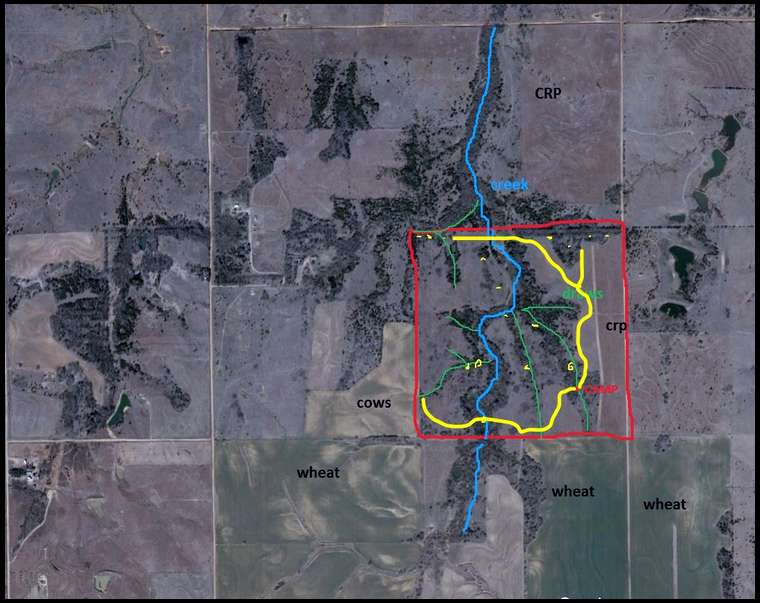
Here is an aerial of land that I can hunt. It is 160 acres in Kansas. There is a corn feeder on the land to the north. There are wheat fields in several directions around the land.

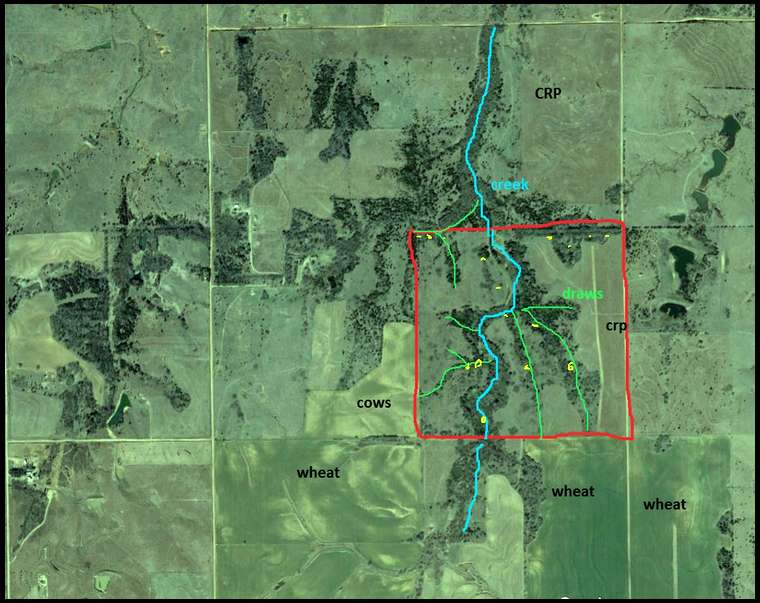
The green areas are creek bottoms. Some run during big storms. The center runs year round no matter how dry it gets.

Where would you start looking for places to hang stands?

From: Genesis
31-Oct-16
The question really is where can you get on/off property with spooking the least amount of deer then work from there......use your topo/terraces to help you navigate.

From: Brotsky
31-Oct-16
Mad, I hunt terrain very similar to this. Based upon your picture it looks pretty steep dropping into the creek bottoms. Try to focus on the top edges, don't drop too far down in. It's been my experience that the bucks, especially during the rut, always cruise those top edges looking for doea,

From: Mad_Angler
31-Oct-16
edited....(originally said SW corner by mistake)

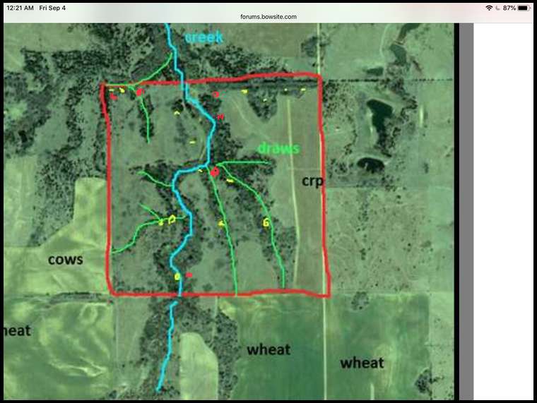
Genesis. I camp in the clump of trees in the SE corner. It is one of the ravines and pretty secluded from the rest of the property. It does take away one of entry fingers but it seemed like the least disturbance...

I also enter from the road on the east. There is a gate in the middle of that edge.

From: Butcher
01-Nov-16

Butcher's embedded Photo
The blue dots are I'm guessing where you camp. The yellow dots would where I would start. I'm assuming you can access from the rd to the east. Entry depend on wind and cover to get there. Also what field seems to hold the most deer to figure where they are coming from. Like others said, don't get too low

From: LINK
01-Nov-16

LINK's embedded Photo
I would only hunt the south one if you can get permission to track off property. If not scrap it.

From: Mad_Angler
01-Nov-16
Butcher... sorry. I camp in the SE corner. I can drive pretty quietly from the east road to camp. But I also try not to drive very much.

From: Mad_Angler
02-Sep-20
Any new ideas?

From: Fulldraw
02-Sep-20
Thats an awesome looking property.... looks like small fingers. I'd tell you to set stand at each of the intersections of fingers, based on access and wind direction. 160 is not an overwhelming patch, and the deer will utilize the draws for feeding and running does out of the bottom to bread....

From: JL
02-Sep-20

JL's Link
IMO.....

1. I don't know what part of Kansas you're hunting, but I'd get on Weather Underground and research what the almanac's prevailing winds have been at the time you will be hunting it this year. (See the link...it's for Dodge City, KS)

2. Based on what you can expect for "the usual" prevailing winds, ID some spots that you can enter/exit without your scent contaminating the area. Have a stand or two set up for the opposite of what you expect (or the almanac says) for prevailing winds so you have a stand to hunt regardless of wind.

3. If the neighbors will also be hunting, find out where they will be setting up so you're not competing for the same location/deer.

4. If the neighbors will be gun hunting, it may be helpful to know where the deer's escape routes are on your property.

5. You said the main creek runs year round. The deer have to cross it somewhere...find that out and see if there are any stand spots overlooking that crossing(s).

From: Scooby-doo
02-Sep-20
Genesis said it for me. Don't look like any real bad spots but accessing the spots will be key. Now as from Oct 30th to Nov 14th just be hunting there, oh and don't hunt the feeder please. Shawn

From: JohnMC
03-Sep-20
Are the banks to the creek steep in most places? If so find where deer are able to cross. My father in laws land I hunt in OK looks similar. There is a creek that runs through it north to south for a half mile. Banks are really steep down to creek.There are two places that deer cross it and those are great places to hunt. Figure out where the topography force deer into a funnel and start there. Assuming you been hunting since you started this thread in 2016 observing deer should have told you where they like to go and how they prefer to get there. Hard to beat what you learn over time from trial and error.

From: XMan
04-Sep-20

XMan's embedded Photo
Hunt the pinch points where you can play the wind and terrain to your advantage. Since you don’t mention food sources beyond the wheat off your place and one feeder to the north, you are force to traveling, bedding, and staging areas. An onX map showing terrain features would really help us pinpoint spots. Also, any oaks on the property?

Looks like a great property.

I would focus on six stands to play the winds, get two for S/SE, two NW And two for SW. I personally like to hunt the edges in KS and focus on intersections. In the south end, focus on that bend in the river that narrows down the woods. Mid map I love that cross section area, that’s gonna be a great rut spot and I would hunt it high. To the north I see a bunch of great intersecting pinch points with what looks like good bedding potential. Just have to figure out where you are at most risk of bumping deer in morning and eves. I put a few of my suggestions in red.

From: Mad_Angler
04-Sep-20

Mad_Angler's embedded Photo
Wow. Lots of good information.

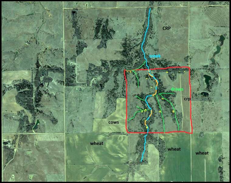
I have hunted this land for about 15 years. The winds are 50% from the north, 40% from the south, 10% other directions.

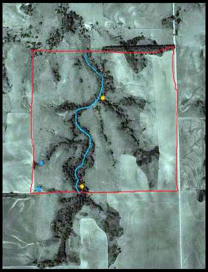
The creek is fairly easy to cross in most spots. But there are some difficult spots. In the offseason, I think I will walk the entire length of the creek and map out the easy/hard sections. Here is a rough map of the creek. The orange sections are harder to cross (but still possible for a deer)

From: Mad_Angler
04-Sep-20

Mad_Angler's embedded Photo
As for access, I camp in the SE draw. I park my truck and walk for the rest of the week. I try to only walk on the established road/trail. I marked camp in red and I marked the road/trail in yellow.

  • Sitka Gear