
Horrible Sight
Contributors to this thread:Elk
From: DL
21-Aug-20
There will be some areas that will be overrun with elk. One year in Oregon where I hunt there was a fire east of the ranch. Elk were wandering around like they were lost.
From: Bob H in NH
22-Aug-20
No fires close to us, but smoke makes for a very hazy look and beautiful sunrise and sunset
From: JohnMC
22-Aug-20
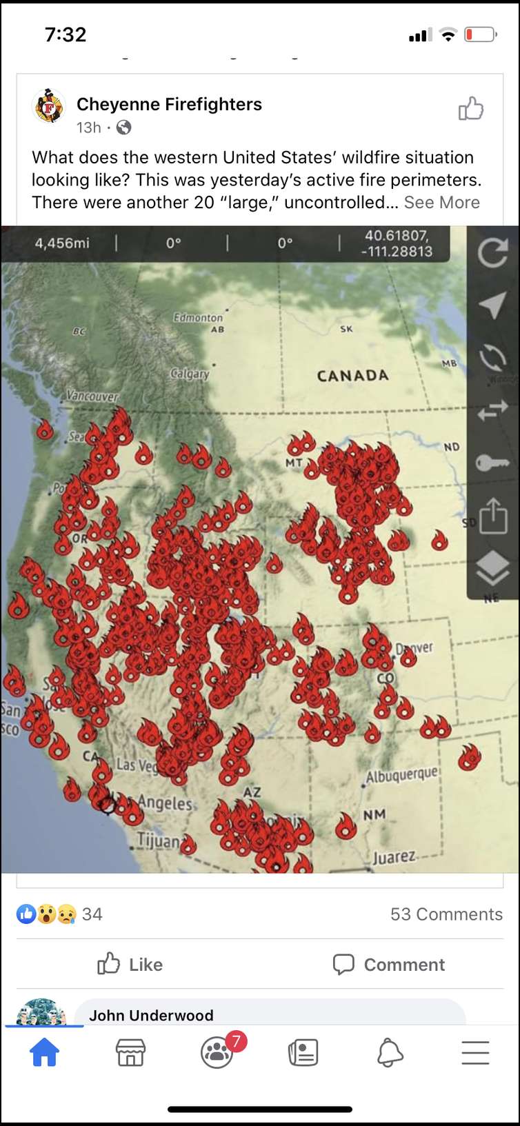
CO has got a lot of acres on fire right now. A lot of the state is smokey. With that said your map/pic is not accurate or deceptive. It looks like there are about 2 dozen fires burning in the state. There are 4 major fires and a few small ones that are contained.
From: cnelk
22-Aug-20


Here’s a better descriptor of fires in the West - from inciweb
From: Jaquomo
22-Aug-20
This is is how it used to look every summer before Europeans arrived, settled, and invented Smoky the Bear. Good for the ecosystems, not so good for people with fixed homes.
From: AZ8
22-Aug-20
This isn’t a very accurate portrayal, at least in Arizona. A lot of those areas marked includes fires that are already out/100% contained, so it makes it look worse than it really is. We had a few pop up this week due to lightening, but overall, there are no large fires burning in elk country here in Arizona.
From: bowhunt
22-Aug-20
I thought I had read there were less wild fires than normal this year in the west. Is that correct?
From: SmokedTrout
22-Aug-20
SmokedTrout's Link
https://www.nifc.gov/nicc/sitreprt.pdf
We're about 2 million acres (40 %) below the ten year average. But was 50% below average a couple of weeks ago. So yeah, that original image is somewhat misleading.
The fires are burning where there are more people (CA, CO). We've been lucky around here (so far) but August isn't done yet.
From: wyobullshooter
22-Aug-20
I agree the first image is extremely misleading. Like cnelk, I trust inciweb to provide accurate fire info/updates.
From: sticksender
22-Aug-20
Right now 98.76% of the state of Colorado is rated as being under moderate drought to extreme drought. Compared to 0% at this same time last year. Coupled with the heat wave currently underway, more fires seems highly possible. Some widespread rainfall is needed, and soon!
From: Whip
22-Aug-20
Fires are always a worry of mine but I've been fortunate and not had one affect my hunts. Not only will they affect animal movements and concentrations near the fires themselves, just as importantly the road closure areas are much larger and will concentrate hunters into areas that aren't closed. Some areas could see huge increases in hunting pressure. As if it isn't bad enough even in a normal year.
From: Tilzbow
22-Aug-20


Smoke in Reno, NV from the CA fires as viewed from my north patio. Since there are fires from southern to northern CA it doesn’t matter which way the wind is blowing, SW, W, NW it’s been constant since Sunday evening. Most were lightening caused. Downtown Reno is centered in the picture but it’s not visible.
From: drycreek
22-Aug-20
Maybe the guy that puts the fire maps out also manages the covid numbers ?
From: Shb
22-Aug-20
Thats not a stretch.
From: joehunter
22-Aug-20
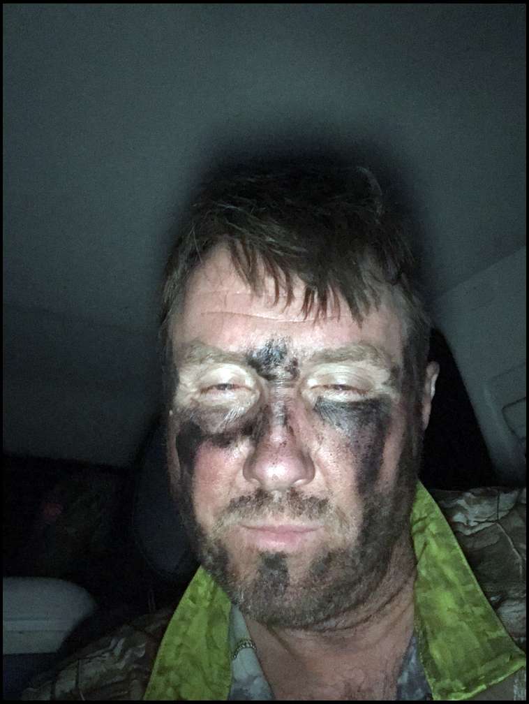

I walked off the mountain in Wy in 2018 solo DIY - guy drove by just as I got to my truck and stopped and said get the hell out of here -there is a mandatory evacuation - see those flames as he pointed to the east. Thank God it was to the East! I packed up my camp and got the hell out. Parked on some roadside pull out in a safe place I started my daily hunt log into my I-phone, but was so tired I happened to snap this pic instead. Never want to be in that situation again! Ever! Two days prior I had been 3 miles in right where the fire went through. I never would have got out! One thing I never tell my wife or kids.
From: Surfbow
22-Aug-20
"With that said your map/pic is not accurate or deceptive. It looks like there are about 2 dozen fires burning in the state. There are 4 major fires and a few small ones that are contained."
This^ The map in the top pic is extremely deceptive, it's like the bubble count maps the media kept showing early on that showed Covid cases, the ones that made it look like the entire country was infected...
From: Tilzbow
22-Aug-20
The map cnelk posted shows past and present fires for this fire season. The devil is in the details and you’ve got to click on the individual fires to view the status. It’s a very accurate map if you dig a little deeper.
From: joehunter
22-Aug-20
I always use icweb maps - most other info using google is just sensationalized.
From: BULELK1
24-Aug-20

East Side of Goslin Mnt./Red Creek drainage-------->
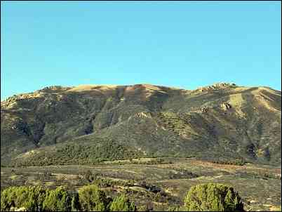
East Side of Goslin Mnt./Red Creek drainage-------->
My 2nd FAV spot to hunt in my Utah LE unit this year is all Black!!!

