I got a problem
Whitetail Deer
Been hunting a piece of land 10 yrs(17 acres), out of the blue another guy says he owns the property my feeders are on, not all the property. My question is, who has to prove who's property it is?
I’d prove it myself with an up to date county plat map.
Can't get in the court house, covid 19
Hmmm I gotta try that with the guy who hunts the land next to me . In reply to the question who owned the land when you started to hunt it. I used to hunt a 40 acre spot and went to check my stand before the fall season. I ran into a guy that said he now owned the property . I called the guy who owned it and he told me oh sorry I sold it over the summer just forgot to tell you !!!
A county play wouldn’t prove anything here.
You need deed calls or survey map. Many counties are now online so you could probably print.
county / and state maps are online. GIS (Geographic information systems). They list the owner and other misc. information that is often helpful.
Although they take time to update, if the property sold in recent days, or weeks, it may not be changed yet.
The one I use gives an interactive map of all the properties in the county, you can click on a property and list owner, assessor, taxes, etc.
oz
It depends. Whichever one that wants to prove they're right badly enough. Until one of you pays to have a survey done, neither of you knows who is correct. Until a survey has been done, there isn't any way of proving where the boundary is.
What is he using to make his claim? What made you think the land the feeders is on what part of the parcel you hunt originally? There is no app or online map that will tell you for sure. Sometimes they are pretty much dead on, sometimes they are off by hundreds of feet. At my house for example the property lines are off by nearly 100'.
A lot of states/counties have tax ID GIS websites. You can find out who is paying the taxes on it. The one we have, you go the aerial map of the property, click on it and a pop-up comes up with that info on it. Owner, parcel number, size, etc.
Most counties have all thier documents online these days. Typically you can go on the county tax parcel viewer, find the property and parcel identification number on the map, search for documents using the parcel number. You can often see recent transactions but may have to pay a couple bucks to see the actual document. See who the owner is on the most recent deed.
Agree with Trax and others noting maps showing property lines are good help here. Not sure it's legally admissible if we are talking court, but I'd have to think it's close enough you could see if one of you is totally wrong or not.
Most places have the property line maps available online via the local gvmt, as others noted above. That would at least help. But the value of an OnX style option is that you could be standing there, and see where you are relative to the property line. If you are just a few yards over, that could be app inaccuracies, but if you are solidly in the property you think you are, that seems pretty darn solid.
This doesn`t sound like a Deed issue, rather just a border dispute. A private property ONX chip could easily diffuse the dispute before getting into a costly p$ssing match. If your close to the border....move the feeders....if your clearly not on his property let the onus be on him to prove you are.
GIS maps are close in many cases. My nephew is a surveyor. I had a line the neighbor showed me on GIS map. GIS map was off by 50 feet. So I am saying close but not survey close! Also not all surveyors are straight or correct either. But once done hard to correct or change.
Like stated above most deed records are on line. Tax collectors and county or state property appraisers have online maps and satellite images that can give you a fairly good idea of the boundaries. I would think that you'd want to be sure. Trespassing and particularly trespassing with a weapon is taken seriously by some jurisdictions. This has happened to me. The new owner would never respond so that I could remove my equipment. So, I went in the same way as the poachers and retrieved it. Good luck.
What does the guy that gave you permission for the last 10 years say?
You need to let the landowner know what's going on. Maybe he will know what's up.
Does he claim he recently acquired the land ? If so just go ask whoever first gave you permission. If he says he has owned it a while then start with something simple like OnX just you get an idea. Ultimately you would likely have to get access to county map info at your courthouse.
I agree with using OnX, or a similar satellite-based app, as a cheap and effective way to settle the dispute, assuming the ownership layer is current. I spoke with a Colorado game warden this year who said they are using OnX almost exclusively to settle boundary and trespassing disputes.
Matt
I hunted 2 sections for years, was hunting it got told by a neighbor it sold went to the new owner and got permission. Hunted 3 more years it sold again, no dice with new owner.
I crack up when I hear guys say onX or other map over lay systems. This is the last time I’m going to say this and, I’m not guessing. OnX or any other mapping system is only as accurate as the county tax map. That may be good enough. However in my experience it likely isn’t going to be.
You need a deed with calls and if you can’t come to agreement, you’ll need it surveyed. That’s it. No napping software for hinting is going to work or be considered accurate. Without plotting the land on the ground. You have to have deed calms. And, if you want it to stand up in court, it’d better be survey’ed.
OnX comes from the county and that is what people are getting taxed on? If that's the case it is absolutely good enough for me. And if, as an adjacent landowner, you disagree then you pay and get a survey.
As a licensed land surveyor and a former County Surveyor who was responsible for creating the parcel line layers on the County GIS and being an avid OnX user I would advise being very cautious in relying too heavily on OnX if $hit gets serious.
The parcel line layer on OnX is based on each county's tax mapping layer in their GIS. OnX does not create those lines but rather they acquire the information from the individual counties and they stitch it all together to make a seamless map.
All County GIS's are not created equal. The United States Public Land Survey corners (section corners, quarter corners, etc) are what control the location of nearly all property corners and lines, except in the original 13 colony states.
In some counties the the parcel line framework is based on the actual surveyed location of the Public Land Survey corners and in those situations the GIS will most likely be very accurate, i.e. within a couple feet or less.
It's very expensive to find, restore and survey the location of all Public Land Survey corners in a county. But every county needs some type of map to facilitate collection of real estate taxes. The original intent of the parcel line layer in a GIS was to provide the tax assessor with an approximate graphic representation of the configuration of a parcel and where it's located to aid in tax collection. In many counties, especially poor or rural counties they couldn't afford to restore and survey all of the section corners but they needed a map for tax collection so they based their maps on very crude assumptions or guesses at where the section corners are. Some parcel maps are based on where the old USGS quad maps assumed the section corners were, and they can be hundreds of feet off.
County parcel maps were never intended to substitute for an accurate survey, or for hunters to determine where property lines are or for Conservation officers to use them to rule on trespass issues.
Some county GIS maps may be anywhere from several feet to hundreds of feet off due to them not being based on the actual surveyed location of the section corners.
When OnX stitches all of these datasets together they end up with a conglomeration of relatively accurate information combined with extremely inaccurate information. The only way to really know how accurate OnX is in your specific area is to know how accurate the county's GIS is and to know which county dataset OnX used (access the metadata).
All that being said, the deeds and documents used to create the parcel lines in the GIS are not the only factor that goes into determining where the actual property lines are on the ground. There are many other levels of evidence that factor into determining property line locations. That's why GIS mappers can't establish property lines on the ground; you have to be a licensed land surveyor.
I own property in Bayfield County in rural northern Wisconsin. Bayfield County's GIS is not based on the surveyed location of the section corners because most of the corners that were originally set in the 1800's have not been restored or surveyed in. I know where 2 of the section corners are that control the location of my property corners. I can walk to those corners with OnX and the app shows that the corners are about 35 feet away from where the actual monument is in the ground. Therefore the OnX representation of my property lines is also about 35 feet off.
I use and rely on OnX a lot but I would be very cautious about relying on it if you're in a situation where you need to know the true location of a property boundary.
Sorry for the long response and all the detail but this is really in my wheelhouse.
Onx (county GIS) would at least give you an idea of if your feeders are near the line or nowhere near it. If you need to split hairs you need a surveyor
My property is surveyed, and I know where the marker pins are. A few of my fence lines are off by a few feet either direction. The OnX boundary lines are dead on.
I'm not suggesting it's the end-all evidence in a litigation. I'm saying it may be an easier and cheaper first step to settling this dispute, assuming OnX shows the most current ownership status. Perhaps the OP will find out his feeders are clearly on the new guy's property, and he can either move them, or politely ask the new guy to allow them to remain. Or, he may find out the new guy is full of sh*t, and he can go from there.
Either way, I'm wondering why the owner of the property the OP is hunting and the new guy aren't aware of their property lines? It's not like 17 acres is the King Ranch. It should be pretty simple to agree where the property line is, and move on. The OP should probably move his equipment and stay out of it until the matter is resolved, IMO.
Matt
OnX has shown private property as public and WG&F had to come out and put up signs stating it was wrong. OnX is not the be all end all. Yes it can be accurate or way off or just wrong. Listen to Cheesehead.
Go see of you can find the survey pins for the boundary.
The neighbor and I had a property line dispute. He got a survey. ONx was off by a lot. I do not trust ONx any farther than I could throw the chip.
Onx is off by about 10' by us. Regarding the property line and who gets a survey, that is a tough one. If you feel that you have permission to hunt the land from the landowner you can keep hunting it. If you do not own the property that you are hunting you can not enforce trespassing, just report him to the owner. If he feels that you are trespassing he can bring charges against you. At that point in time you will probably need an attorney as most prosecutors will not talk to the accused except through an attorney or you can plead no contest and pay the fine. I wonder if your attorney would recommend going to court w/o a survey to argue landownership for a non-landowner. If you can get your landowner to testify that you were hunting on his land and he owns it and gave you permission the case would probably to thrown out but that still does not determine ownership. Otherwise the courts would probably rule in favor of a landowner vs a hunter in a property line dispute lacking a survey. You would be out fines, court costs which are higher than the fines and attorney costs. If the landowner of the land you are hunting can not or will not resolve the boundary line dispute I would suggest that you move your feeder.
OnX have the property lines wrong on our property. Not just off a little, missing a chunk of the actual shape, about 5 acres worth. Its surveyed.
My house on the other hand is darn near dead on. So it depends on the case, but im not ever doubting it being incorrect
Is it really Onx that is off or is it the gps receiver in your phone?
The GPS receiver in my phone shows me sitting within a foot, or so, of where I actually sit as I type this.
Matt
I wouldn’t bet the farm on either On-X or Hunt Stand to stand up in court, with the exception of getting you out of a tresspassing charge. I’ve checked my property lines with both and they are both off, just not off in the same places. LOL !??
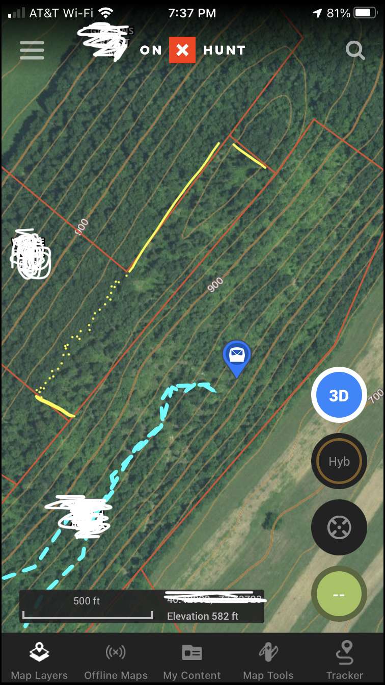
The lines are off lucky. This is a screenshot, u can see our line goin along the top of the ridge(red line), but it should jump over the top and include the lil chunk on the backside there inside the yellow line/dots i drew. The rest of the lines themselves are very close everywhere else, just this chunk that is incorrect. If someone from that property was to approach us and claim anything based on the onx lines, they wouldnt get far.
Having said that, IT MAY help to give an idea of where the lines are in the OPs situation. Or maybe it wouldnt....
What Cheesehead Mike said. Where I live in CO the USGS came in and did a survey and found that the original property surveys originated from a single old point that was off by about 150 feetz discovered by using updated technology. The company that surveyed it back in the early 60s is no longer in business. GPSs showed the property lines as accurate, when in fact they were not.
The USFS kindly offered to sell the land back to the owners at today's market value of roughly $30K per acre. Two owners were told they had to buy their houses back, or tear them down. It went to court, and the USFS claim was upheld.
Our Congresswoman took it to Congress and actually got a law passed that restored the ownership to the current property owners, using some archaic precedent. But the point is, OnX is only as good as the information fed into it.
Yeah I guess the OP could get OnX and if it helped prove his case and the other guy accepted it, it would be a cheap solution.
On the other hand if the neighbor does not believe or accept where OnX says the line is, he's back at square one and may need a survey to settle the issue.
Sounds like some are blowing this out of proportion...."arrests....court cases"....come on guys....it`s a land border dispute over 17 acres and feeders.
Go to the guy and say...."according to my GPS and the land owner I am on his property"....then he will respond with...."according to my survey you are not". Then it gets worked out.
You can`t charge someone with trespassing if you don`t have PROOF they are trespassing. If he does have proof you simply ask him for it. A simple discussion will solve this. Sydney Powell doesn`t need to get involved...lol
You can charge someone with trespassing and they have to prove they were not. In most states it is up to the individual to know where they are at all times, and provide proof.
"Then it gets worked out".. Yep. I'm involved in one now involving a small walking/biking/horseback easement to National Forest across one acre that has now been in court in two day trials four different times over two years, is waiting for the final judgment, our insurance company has paid nearly $100,000 in legal fees and expert testimony, and the plaintiffs have paid more than $100,000 in legal fees to challenge the easement. I was accused of criminal trespass in court, from trail cam photos, even though the easement is clearly defined on the current property owner's deed. It ain't that simple when it comes to land disputes.
The landowner has owned this prop. for over 20 yrs, and he bought it from his dad, this was the old home place. I'm not sure who built the fence. My nearest feeder (I have 2 there) is about 20 yds from the fence. I tried to my onx there recently but it showed no info., It use to work there, it showed the prop. was in the owners daughters name.
It gets worse, the prop. is for sale, with sale pending for 60 days. I was hoping the new owner would let me hunt there or lease me the hunting rights., I was hoping to hunt there the rest of this year, then remove my feeders and blind, then this comes up about prop. lines after all these years.
Mike brings up some good points above. I could write a couple chapters on this topic in my limited tenure as an attorney of 16 years re easements, property lines, and even “county line roads.” Until you have a CSM you can’t rely on GIS, plat maps, overlays, or certainly any of the online related gatgetry that rely on county mapping. Fences mean absolutely nothing unless you’re talking adverse possession.
I guess what I really need to know is, what do I say if the (supposed new land owner) comes up and tells me to leave, or face legal action?
You have 60 days til it closes. There is No new landowner until then! Looks like you have two months to hunt :)
Sorry Jaq but in America you don`t have to prove you`re innocent, that`s not how the system works.
Your example of access to National Forest sounds EXACTLY like the OP`s situation....thanks for contributing though.
From all information the OP has he believes he is in the right. He has no intention of trespassing and has done so for the past 10 years. Communication will solve this issue within an hour.
When I said new land owner, I was referring to the man that's claiming the fence is not right.
So your feeder is on the property line? That's going to annoy any new property owner move it
In Nebraska an existing fence that has been used as the property for ten years straight is considered the property line. Not sure how many other states have a law like this.
With 17 acres everything is on the property line.
Beav, there's probably more to it than that. You can't change property lines just by moving a fence. A judge would have to rule that the conditions of adverse possession have been met and the fence is now the property line. Then the deeds of record would have to be changed to conform to the facts on the ground. Most states have a doctrine of adverse possession and the length of time a fence or other line is accepted as the property line is just one factor in proving adverse possession. There are many other conditions that have to proven such as the possession has to be "open and notorious, hostile, continuous" etc and in some places taxes have to be paid on the land.
In 40 years as a land surveyor I've only seen a handful of successful adverse possession cases. It's a difficult burden to prove that you've successfully taken somebody else's land and it can't happen until the courts have ruled that all conditions of adverse possession have been satisfied.
Sorry, Franklin, but with trespassing, you DO have to prove you are where you are allowed to be. You don't understand the law, or how the legal system works. A Sheriff will believe a landowner 99.9% of the time, as will a judge, unless you can prove you were in the right with GPS or some other method. Even then, it can be challenged, as we have learned the hard way. If you believe the boundaries are off, it's up to you to prove it.
"From all information the OP has he believes he is in the right. He has no intention of trespassing and has done so for the past 10 years. Communication will solve this issue within an hour."
Sure wasn't resolved in an hourlong discussion in our case, even though the GPS, county maps, USFS maps, and the actual legal description on the property owner's deed shows we were in the right. The landowner challenged the wording on his own deed and intent of the easement when it was originally granted, and here we are. It has taken two years, four court trials, and hundreds of thousands of dollars in attorney fees as in our case.
Armchair quarterbacking is usually way off base, especially wrt land use issues about which the commenter has no clue.
Mike is right again. I just finished participating in a lengthy adverse possession trial too, related to NF access (and related to the dedicated easement trial I mentioned before). This NF access through the contested property has been ongoing for 50 years, and after two two-day trials and a whole bunch of witnesses, the judge finally granted us an easement via adverse possession. But he didn't agree to a land ownership transfer, only an access easement for foot, horse, or bicycle. Seemed like a slam dunk by the law, but as Mike stated, it is really sticky.
Based on your last couple of posts, I’m assuming that the guy telling you he owns the property is the buyer who has it under contract. However, regardless of what he says, he does not own it until it closes. Contracts contain wording granting the buyer a period of time to conduct any due diligence they feel they need in order to be comfortable moving ahead with the purchase. That period varies depending on the type of property and the timeframe that the parties agree upon. It is likely that they are in this DD period and the buyer has the right to be on the property during this time. He is probably letting you know so that the feeders will be removed before closing day when he legally takes ownership.
As others have said, I would talk to the owner. I would find out the details on when closing is scheduled and remove the feeders before that day. If they are still up after closing the new owner may not allow you to get them since he has given you verbal notice.
It stinks, but I suspect most of us have had a similar situation with property being sold. I’ve had it happen twice and wasn’t notified either time. Fortunately, I had removed all my stands during the off-season.
Sounds like there are 2 different things going on?
1- the neighbor says the property line is wrong and your feeder is on his side?
2. The land you have permission on is sold to a new landowner and will close in 60 days?
This sounds like the neighbor knows the land sold and is exerting his perceived rights to the border that may have been off? If the property truly sold there should have been a new survey. But in the long run you are out anyway so I say move on ASAP and start figuring out a new spot for next year!!
Jaq that is pretty funny!!
Jaquomo, probably a little nitpicky but technically you don't aquire easements through "adverse possession” because the adverse "use" of the land doesn't rise to the level of actually "possessing" the land. The requirements and proof necessary are very similar but when it's an easement it's called an easement by prescription, or a prescriptive easement.
You are correct, I used the wrong terminology and I know better since I worked on this damned issue for two years.
You are correct, I used the wrong terminology and I know better since I worked on this damned issue for two years.
No worries, I figured as much :-)
This is maybe the most famous adverse possession judgment in the country, from (where else?) Boulder CO. The neighbors were awarded a substantial part of the defendants property because the neighbors had used it as their own for more than the required 17 years. Crazy.