
airrow's Link
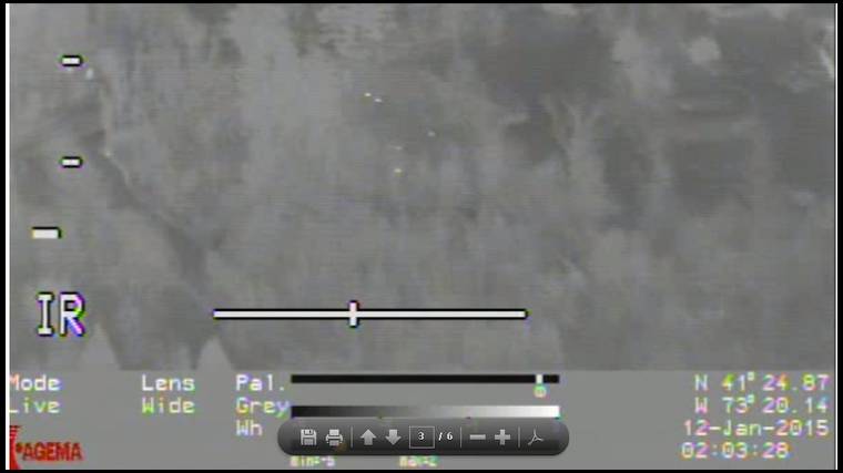
is that the actual footage of the CAES survey? I can't believe you can determine what's a deer and what's not a deer, and the speed seems like 200mph??? One other thing stands out - LARGE areas with no marks at all,....nothing!!
Dr Williams - can you explain what we're looking at?
Bottom row shows from left to right - Coordinates (N latitude - W longitude), Speed (in knots - about 85 to 101 miles per hour), Course
The barcode on the left is a possible indicator of apocalyptic association with Antichrist. Comes standard with almost all available products used by humans today. No extra initial charge.
The video may seem fast due to possible stitching and conversion from original files to YouTube format. It is not a continuous filming as if you watch time and coordinates you will notice quick changes when the video seems to skip. At times the camera hovers over areas which show deer - for example 7 to 8 animals at minute 8:35 in the YouTube video (perhaps Huntington State Park location).
No housewives were filmed during the survey, but I saw notme and Steve at their respective locations, waving and smiling. I am so tempted to get me an autonomous long distance capable quadcopter equipped with a FLIR camera for overnight scouting before hunts. Oh, wait, we now have to register them and play by restricting rules thanks to FAA. Strike that thought.
Dr. Williams's Link


And Scott, before you embarrass yourself any further with your " 25 % detection nonsense, " let's set the record straight. You got some bad information from Davis when he told you Vision Air misses deer because when she zooms in she's still flying and is missing deer. Wrong ! The housing has multiple cameras and continually scans on one while another is used to zoom in to confirm the targets are really deer. But then I'd expect better quality results from $250K worth of equipment over a hand-held IR camera for about 2 % of that.
This is what deer look like through a good camera at 60 knots !


Anybody got the standard deviation for the study in deer per square mile?
BTW my 8 year old daughter was picking out hot spots in the woods with the video running full speed. So a trained professional watching frame by frame should have no problem get a good count..
I'd love to get this kind of data in the NW corner to validate the areas I hunt via " ground thruthing".
And again...a true hunter is someone who kills everything in front of them??
I would think private property holds more deer, simply because there is more private property than public land as a whole in CT, hence there are more deer on that total percentage of land. A grade school kid could figure that out.
Also, what good does it do to hunters, the general public, landowners, etc if those pieces of private land don't allow hunting?
" So Bloodtrail. We ground truthed the deer Davis found on public land and those private lands we had permission on and then we drove on public roadways the neighborhoods where lots of deer were seen."
The CAES and WB shot 11 deer over the next 3 days and billed the tax payers $20,069.22 for their services. The 11 deer were taken over a 3 square mile area ( 2 ) test sites and in doing so negated a $950,000 study by over harvesting what was in the test sites areas. Vision Air had FLIR surveyed both test areas prior to the Davis survey and found only 23 deer and the CAES had been baiting the test ares prior to the Davis survey. By the CAES taking 11 of the 23 remaining deer that were left in the two test sites they were under their test site parameters by 8 deer. The test sites were to have 10 deer remaining per site and were stated to be 1 square mile each; when in fact they were just over three square miles combined, a 50% increase in size thus negated the test study again. And how do we know this, We were there and ground thruthed it.
Right that deer are on private land because 94% of the state is private. But on public land, densities of deer are super low from being hammered by guys.
Whatever Glen. We didn't ground truth 11 deer, White Buffalo shot them in the head. And we didn't over harvest the test sites either. We are crunching the tick data now and the deer aspect is like nothing ever happened. We needed to have a lot more deer taken to reach our goals. Amazing that 87 deer were removed from 2 square miles over three years and it didn't even make a dent in the Redding population.
Now, you go walk any private land spot and I can almost guarantee you that someone is hunting, trespassing, poaching, riding quads/dirt bikes, mountain biking, hiking there. You'll find treestands, blinds, illegal bait piles, trail cams, evidence of humans....
But will you try to envision gaining access to private property (not in someone's backyard behind the swing set) and every piece you were able to scout, you found treestands, bait piles, evidence that others were hunting (or poaching) there. Or the landowner hunts there, his son, a distant uncle or cousin, etc......or the neighboring piece has treestands all over it and is hammered by guys. Heck, most of the state land I hunt has treestands all along the border on private lands.
It's very difficult to find private property that isn't walked on or been around by someone trying to kill a deer. Very difficult.
I don't feel you are being completely open and vulnerable to this. The reason you get so much static here is that you won't allow yourself to be open to what we can do to improve the quality of the hunting in CT. Imagine the possibility of using of what we know to improve on our experience in the woods....
I can see your response already, "That's right Blood, if you guys just banded together to kill every single deer out there, you'd be heroes."....however we are looking at it from another angle. Quality hunts. We can do this, without question.


What does he talk about ? He tells you, me and anyone who doesn't whistle his tune they're crybabies, they don't know anything about hunting and the hunting heritage that's part of who they are is gone, dead and buried. He tells everyone the new world order is to become paid assassins and shoot every deer, any deer that walks past them. He tells everyone " my way or the highway," anyone who doesn't want to sign up to be a wildlife terrorist can fight over table scraps.
He talks about hunting like it's nothing more than calling Terminix to exterminate cockroaches. You can't talk to someone like this because they haven't a clue about what hunting is and they never will. Just tell this guy he should be on www.wildlifeterrorist.com or www.killeverydeer.com because he has no place at this table and never will. We're not buying what he's shoveling.
If I hunted every day, I could kill a bunch of deer if I wanted to. You're not comparing apples to apples again. And before you say "I told you there are lots of deer around"...that's the rarity now.
But I'm "That Guy", your average bowhunter that gets out on the weekends and a few times during the week for a morning or afternoon hunt. Been bowhunting over 30 years in CT....and it's not like it used to be. It's actually worse than I've ever seen.
Can't we just figure out a way to bring quality back to all the areas of the state collectively? Why won't you open yourself up to that?
Lastly, your guess on the 10% of land being hunted I think is way off. Like I said, I think most pieces of private land in CT are being hunted legally or illegally (I'd lean more on the illegal side), or being trespassed on. Deer don't know property lines. And you can't tell me that when the harvest report shows the majority of deer reported killed being from private land, that they are only coming off 10% of it??
"Ok. Like i said, probably 10% of CT is actively deer hunted. A good estimate?"
" I'm guessing maybe 10 of those 640 properties are hunted. But I bet all 640 properties have at least one wireless network with multiple smart devices attached."
That's a lot of guessing, did you do your PhD research that way too?
You keep referring to FFLD county. Lots of guys on here hunt other spots in CT. I do. And if we ran a post on how many guys here have private land, I'd think most guys have private land to hunt. That could be why the majority of deer are reported killed from private land on the harvest reports. So again, I think private land is getting its fair share of someone trying to kill a deer.
Dave hunts almost every day, doesn't he? He's not your average bowhunter that gets out a day here or there. He sure is a killer. Let's let a dead dog lie.
Why won't you assist with changing the management tactics that are ancient and outdated in this day and age?
Go to the towns like New Britain, Bristol, Hartford, Bridgeport, etc and tell me how many acres of private land actually hold deer. Even the FLIR Dr Williams provided shows large tracts of land with zero deer, so why even consider those in the discussion around hunt-able acres?
I think Blood is more accurate in saying the larger, hunt-able tracts of private get hunted because that's where the deer are. I'll give permission to anyone who wants to sit in my oak trees on my 3/4 acre lot, but I can tell you first hand, there are no deer there. All I have to do is look out my window and "Truth" that fact.
Dr. Williams's Link
Bloodtrail. Ok. So now your assertion is that any huntable private/ public land is under a lot of pressure. I don’t disagree with you as you can see in one of my previous posts: “Guys are clustered and pressured in huntable areas, mostly public but some private. Likely 10% of the state. Where there is room to touch off a round, release an arrow, to be able to drag a deer out without causing too much fuss in a neighborhood. Right? That's where you see the sights as you describe.” That is a far cry from you saying “It's very difficult to find private property that isn't walked on or been around by someone trying to kill a deer. Very difficult.” Again, hunters only think about huntable land, which is like 10% of the state. I completely agree that that 10% gets hammered and deer densities are way down. But there is still 90% of the state that is completely unhunted where there are plenty of deer. A for instance: when we flew Redding, do you know where we saw a TON of deer, was on Highstead Arboretum (private with no legal hunting) and on the adjacent golf course, also private. There were tons of deer there and zero hunting pressure as you describe. Just because these private properties are not hunted, doesn’t mean deer are not there. Those deer count for the density calculation and there are lots of them. I have no say in management tactics of DEEP. I work for a completely different agency, I just understand DEEP’s logic and justification: the public process.
Smoothdraw. I am not sure about the current bowhunting regulations. I would have to ask at DEEP. DEEP too realizes that the population is decreasing but they also realize that there are still a lot of deer out there as I have been saying. The population is being corrected from the insane highs it was before. Again, do not expect DEEP to be relaxing take anytime soon as long as they are still counting an average uncorrected density of 26 deer/square mile.
Bob. Yeah, you are right. There are no deer on private land that comprises 94% of CT. That is the reason it remains unhunted. The deer all seek refuge on huntable acreage loaded with guys trying to kill them. Deer are wicked smaht like that. They flee the safety of 2-4-acre zoning during the season and head into the Big Woods in hopes of getting an arrow or bullet between the ribs. I wish someone had told me that deer behave in this manner sooner or else I wouldn’t have been posting all this stuff about how smart they are.
"This research would not have been possible without the financial support from White Buffalo, Inc. "
for an intelligent man you're terrible at paraphrasing what I wrote. I never said there are no deer on private land. In fact I said that you are correct, most private land doesn't get hunted.
The statement you don't agree with is that there's a great deal of private land that has no deer. How do I KNOW this? I used EXACTLY the same method to verify my scientific findings as you did with your deer study. I looked at those areas that are private land and I don't see any deer, therefore,.....
“. . . but that's because most private land in CT has no deer on it!!” ---- Bob
When you see Deer from the air, and then land, drive over and count them on the ground to "ground truth" them. Do you still multiply by 2?
so you say that deer leave the areas where hunting occurs and previously you stated that the public land in Redding is open to hunting and has tons of deer on it as shown by your aerial survey, AND this was told to the group while bow hunting was still in season. Please explain how both statements are true.
If you doubt my statement please come to 600 Myrtle St, New Britain and we can walk throughout the city looking for deer and deer sign. Or you can come to my neighborhood and go through all of the backyards. This I was told is "Truthing" the fact if deer exist or not. You taught me well Dr Williams.
And Bob, I have said repeatedly that when I broke down where deer were in our 2015 Redding survey, 83% were on private land AND there were a boatload on HSP which was surprising because it's open to bowhunting. We ground truthed it because the only logical explanation we could come up with for that many deer there was that some had placed a bait pile. So we looked. No bait but lots of deer.
Ace. I don't work for DEEP. Never have I used a correction factor of 2. Ever. Thank you, come again.
But wait, he also said the public land in Redding (hunted hard remembered) has plenty of deer on it. How can that be? Didn't they run away as Dr Williams stated is always the case?
I'm sure Dr Williams will tell me why I'm so confused. Could it be because he contradicted himself to suit his side of the argument? No, he's scientist, just the facts from him.
And tell EXACTLY how much of the private land in CT holds a hunt-able deer herd. You must have the data since you're saying I'm wrong. Or is it just your opinion and not science based fact? Like my facts are just my opinion and science based using Truthing.
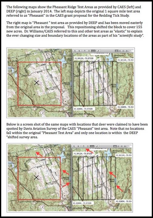


Glen, come on. You expect us to believe this? Why not something believable like 8 or 19. Zero deer. You are telling us zero deer were seen by Davis Aviation in the Pheasant Ridge area where the previous year Siburn helped to visually count 45 deer/sm with Wildlife Director Rick Jacobson? Am I getting this straight? Zero deer?
Scott, as you like to tell people to calm down perhaps you should take your own advice. Take a breath, re-read what I wrote and focus on the words "no deer in the original test area." This doesn't mean no deer anywhere, just no deer in the original test area.
" Glen, come on. You expect us to believe this? Why not something believable like 8 or 19. "
I'm glad you said that Scott; there are 18 deer shown on the film, they just happen to be outside of the original test area. Thank you for stating you find that number believable as you indicate in your quote " why not something believable like 8 or 19. " Your sudden burst of honesty is truly refreshing !
Everyone also knows that I asked " If the CAES can provide the additional deer locations as stated and time stamps viewed on the Davis film, we will add them to the survey map above." Should I take your response to mean that you either can't find any deer and therefore can't share any time stamps ? By the way Scott, everyone also knows I didn't say there were no deer on the film, just that the deer seen were outside of the study area. I also think everyone noticed how you avoided addressing that issue.
" I stand by the CAES, Davis, and the joint DEEP/CAES/Siburn flight results of approx 45 deer/sm in the area in question. "
Alright Scott, let's look at whether that confidence is justified. If all of your survey methods are correct and there were approximately 45 deer seen in the White Birch study area by Davis Air then why was it necessary for White Buffalo to shoot up to 5/8's of a mile outside of the study area to take less than your target goal ? As you have pointed out in the past White Buffalo is not hunting and has the advantage of shooting after dark using night vision equipment. If your numbers were accurate you should have been able to meet your target reduction of 12-25 deer within the test site. The results simply don't match up at all with the accuracy claims/numbers of your surveys.
" I have zero confidence in anything produced by VisionAir and even less in your synopsis of someone else's survey, just so we are clear here. "
The results clearly indicate we should have zero confidence in any of your survey methods; just so we're clear here.

Dr. Williams's Link
Davis Aviation was a subcontractor that provided us a service at cost and you FOIAed that information and I gave you everything including the raw footage. Can I view VisionAir’s raw footage of Redding and Newtown? Please? Pretty please?? With a cherry on top??? No, because I know that you, the paying customer, doesn’t even have it. Why, because she knows it sucks. And to suggest that I doctored any footage or hid anything based on your untrained eye watching videos of someone else’s work using their equipment for heat signatures you aren’t qualified to review and don’t understand is insane. For how much of that footage you viewed were your eyes open?
Glen no. Just no. “. . . there were approximately 45 deer seen in the White Birch.” No! We are talking about Pheasant Ridge, not White Birch. Never have I said there were that many at White Birch, ever.
I have attached the screenshot of Davis Aviation’s locations of deer in Pheasant Ridge, and again, the link to that report.
Clearly you are trying to drum up justification for your 5 town VisionAir survey, which ultimately, is just a waste of your money. What good is going to come of it? Anyone in DEEP or who makes management decisions on deer knows her surveys are junk. But you will be able to post about the results here. . .


Actually Scott you submitted a report to the CT DEEP per your ITM study requirements that did in fact show ( see attached file ) within the White Birch Study area 44 definite and 1 possible deer. Just so we're clear......44 + 1 is 45. I'm sure most readers will conclude as I did that you submitted a report showing 45 deer on White Birch on the one square mile test area. Again, just so we're clear the report shows the area as 640 acres, which as I'm sure you know is one square mile.
I'm sure the CT DEEP would be very interested to learn that the CAES spokesperson denies ever claiming a deer count he submitted in an official report used to justify the spending of over $950,000 of federal grant money.

Dr. Williams's Link
Glen you keep threatening me with the equivalent of “I’m going to tell the teacher on you” with junk “science” you have made up out of thin air or something I never said. Go ahead and tattle on me. You go to DEEP and say “. . . that the CAES spokesperson denies ever claiming a deer count he submitted in an official report used to justify the spending of over $950,000 of federal grant money.” Knock yourself out. This is not threatening to me in any way because I can back up all these bogus claims of yours with documentation and fact as I am right here and as I have all along. I never said what you are claiming and I did in fact submit to DEEP a report that you are quoting back to me in which I said that the White Birch density was 24-25 deer/sm. I posted that link right here for all to see.
Do you think it is in my best interest to post lies on this site to suit my "agenda"? For all to read if they so chose? For you to forward to DEEP? Do you think I am that mentally challenged?


With regard to the White Birch study area; the attachment is the letter you sent (and signed) to William Hyatt of the CT DEEP on Jan 16th in which you specifically mention meeting the criteria for the deer cull to proceed and specifically state that Davis Air found 44 definite and 1 possible deer " within the approximate one square mile White Birch area." White Buffalo began shooting within 24 hours of this letter as the letter stated approximately 45 deer in the White Birch test area. Of course we now know the actual surveyed area was 2.12 square miles and we also now know that less than 10 deer were taken approximately 5/8's of a mile outside of the original test area.
The fact that your final report accurately reflected that the White Birch survey was actually 2.12 miles is irrelevant; the deer cull had already been completed well before Feb 4th when you submitted the final report you posted in your link to the CT DEEP. How convenient that you knew the survey was 2.12 miles but chose not to notify the CT DEEP until after the deer had been shot. Including the actual surveyed area in the final report was covering your ass and nothing more.
Dr. Williams's Link
I'm not spinning anything and I don't have any GPS coordinates from the Davis flight. I didn't do the flight, Davis Aviation did. You have everything that I have from that flight per your multiple Freedom of Information Act requests and Sanford's near daily calls to our CFO. If you want to see the results from my 2015 flight you can see them in the link provided here.
Glen, you are wrong. There were a ton of deer out there as confirmed on flights by me and my crew, Davis, DEEP on their flights, and CAES/DEEP/Siburn. This isn't a conspiracy. You are creating this drama. Vision Air's method sucks at detecting deer. You and Mike are the only ones still fighting this fight. CAES, DEEP, and Davis Aviation flights all confirm plenty of deer on the ground and we are all in the same ballpark. Take any of this to DEEP and Hyatt, Rick Jacobson, and Susan Whalen will nod their heads and say, "Yup, Williams is right. That is what we were looking for and that is how it happened." And anyway, 5 or 6 deer were taken from that area in 2015, of the 50+ Davis reported. So what is your deal now? I know, you don't like or trust government. That's it, the only logical explanation because everything else in your "argument" is just ludicrous. It's over man. It's been over for almost a year.
None of those things should have been necessary if your numbers were accurate. You certainly shouldn't have had to mislead the CT DEEP in your Jan 16th letter as you clearly did; you established the area Davis was to fly so you knew the number you turned into Hyatt was almost double the actual number (at best). Actions like that only poison the relationship between CT sportsmen and the CT DEEP. Actions like that will ensure this fight isn't over by a long shot.
CAES - " That's 100% accurate information and all I knew at the time. "
We had the film provided by the CAES reviewed. The good news for the CAES is, that another 7 deer were found on the “Pheasant Ridge and White Birch Road” film provided by the CAES through our FOIA request.
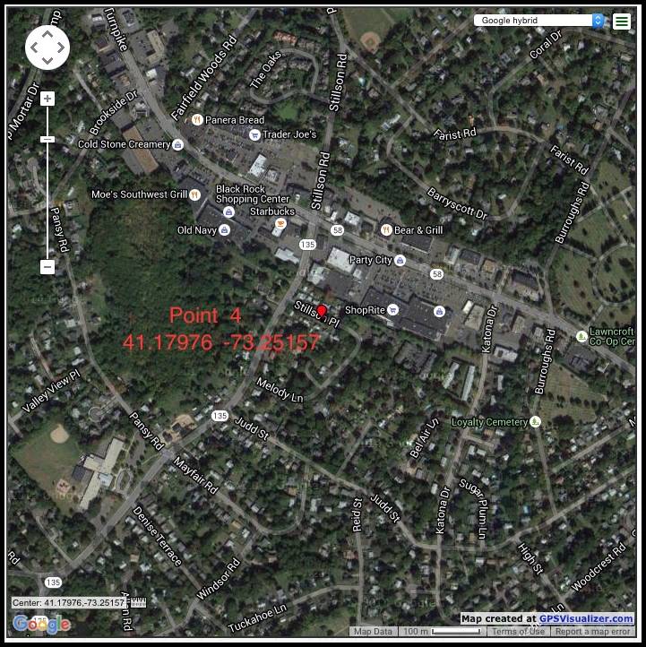
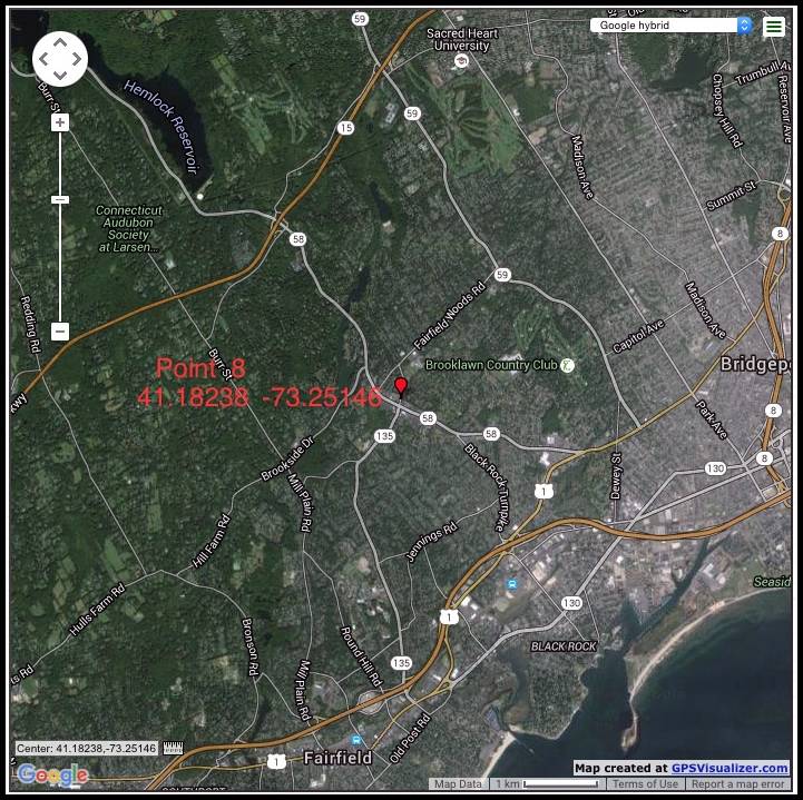
The bad news is that all of these ( 7 ) deer were located south of the Merit Parkway in Fairfield, CT. This is 10+ miles south of the original test area in Redding, CT. The Lat. Long. coordinates are as follows:
41.17976 -73.25157 1 deer / 2134:25
41.18387 -73.26313 1 deer / 2138:35
41.18016 -73.25125 2 deer / 2149:12
41.17985 -73.25118 2 deer / 2151:09
41.18238 -73.25146 1 deer / 2151:21
Deer on Davis IR film provided by the CAES:
Original CAES 1 square mile Pheasant Ridge Test area - 0 Deer
Shifted DEEP 1.5 square mile Pheasant Ridge Survey area - 8 Deer
Fairfield, CT. 10+ miles south of Redding, CT - 7 Deer
Outside of the test areas in Redding, CT - 10 Deer
The CT DEEP Volunteer Authorization # 1135006B required that there be more than 8-10 deer in the test area to proceed with any additional take of deer.
Bob, I am hardly "driving the process for deer hunting in CT." And Glen isn't "auditing the process." He is making up numbers.
Looking at the back-and-forth there’s something that just doesn’t add up; if the study surveys were right, if the results were “ground-truthed” and showed “tons of deer” in the study areas then it makes absolutely no sense to have Davis surveying more than 10 miles outside of the test areas-none whatsoever.
Sending Davis that far out of the test areas would seem to indicate someone (or more than one someone) had reason to suspect there weren’t as many deer in the test areas as they’ve led people to believe.
Hmmm...and all this time I thought DEEP laid out the groundwork for the process of deer hunting in CT. I was not aware the CAES did this.


No Scott, and it wasn't even one of your better efforts at spinning.
Read the report. It's all there and hasn't changed.
Read the attached map Scott; all 4 study areas were in Redding, Davis was surveying in Fairfield.
The location of Fairfield hasn't changed Scott.
Try again.
So now if you're done spinning and insulting the intelligence of anyone who can read a map try to answer the question; why was Davis surveying more than 10 miles outside of the test areas in Fairfield?


Dr. Williams's Link


"If all your surveys were accurate and if "ground truthing" showed "tons of deer" in the study areas what was Davis doing filming deer in Fairfield?"
Was the intent of the study to get it published in some Wildlife Biology Today journal? To add another study to the list of studies completed? Or was it to provide ground work for determining the correct deer herd population for the health of the general public? That's what I thought it was about?
Are you denying that all of the conversations on this site about Block Island deer reduction, the studies in insular settings, the FF county study never suggested that less deer MAY equate to less Lyme disease?
Are you denying that you've stated over and over that hunters need to change, to become animal control officers to kill all of the deer if the landowners wanted that to happen and that's the future on hunting in CT?
The meetings you attend with the towns people in FF county where you tell them that by reducing the deer herd they have better chance of not contracting Lyme disease, is that not impacting hunting in that area?
And I thought you said the DEEP approved all of the study requirements (killing deer) prior to WB going out and killing the deer? I took that to mean that you don't with FOR the DEEP but you certainly work with them.
You may try to say it's wasn't the purpose of your study to change deer herd numbers in CT, but please don't deny the fact that studies like yours are considered (that's the word I used, CONSIDERED) by the people in charge of deciding how many deer there should be in CT.
What that response tells me is that you still haven't reviewed the film; you may want to consider doing so to avoid putting your foot in your mouth again.
Allow me to illustrate your ignorance of the facts:
According to the time stamps on the tape the CAES survey film (provided per FOIA request): On the disk labeled Pheasant Ridge/White Birch, at 2020:11 (8:20pm), Davis Aviation was surveying/filming an area with coordinates that were confirmed to be in the vicinity of Pheasant Ridge in Redding, CT.
At 2134:25 - 2151:21 (9:34-9:51pm) the film showed coordinates that are confirmed to be in the vicinity of Route 58 in Fairfield, CT.
So much for Davis testing out his equipment prior to starting his survey.
Perhaps you should have stuck with the "Hot Pockets" defense; that at least had the benefit of being amusing and not so glaringly wrong as your lame explanation above so obviously was.
Now if you're done with the histrionics and nonsense the question remains on the table: "If your surveys of the test areas were accurate and "ground truthing" confirmed there were "tons of deer" why was Davis surveying/filming in Fairfield?


any response to my last posting?


Are you ready for my “spin?” Are you ready for me to show you “your ignorance of the facts?” Are you ready for me to answer your question "If your surveys of the test areas were accurate and "ground truthing" confirmed there were "tons of deer" why was Davis surveying/filming in Fairfield?”
The answer Michael, is that he was always in Redding and you guys know little about latitude and longitude coordinate systems. You see Mike, look in the read out from Larry’s raw data in the attached image. See down at the bottom where it says “4117.327N, 07326.233W?” Well those are what are called “latitude and longitude.” But see, this read out is in Degrees, Minutes, decimal minutes or DDMM.mmm. Now if you scroll up to the images Glen provided with his super sneaky sleuthing, you will see that his coordinates are in what we in the field call “decimal degrees” or in this form DD.ddddd. So what Glen did was do a Google search for coordinates that were meant to be in DDMM.mmm in this form DD.ddddd.
Ok class. Now we are going to do an exercise together. Hold on, let me put this Hot Pocket down, ooohhh hot, hot, hot. Burned the roof of my mouth. Darn. Water, water. Ok. Let us scroll up and look at Point 4 Glen provided incorrectly in decimal degrees: 41.17976, -73.25157. Now class, I want you to copy that coordinate pair as is and enter it into the Google. Ok, we there? Good. I think we can all agree that we are in Fairfield somewhere north of Melody Lane in the vicinity of 27 Stillson Place. Right? Just like Glen’s image. Ok class, now let’s Google the same numbers, but in the proper DDMM.mmm format like this:
41 17.976, -73 25.157
We agree those are the same numbers Glen provided, just in the proper format matching the output of Larry’s GPS? Right? (Google requires the space between the degrees and minutes to recognize it as a coordinate pair.) And now I think we can all see that that puts us right back off Umpawaug Road in the White Birch study area, back in Redding, CT. Conspiracy averted. Phew. Now where is that Hot Pocket???


Your response to Steve’s question was absolutely spot-on; something we are in complete agreement on.
Many of my posts(and Bob’s, Kyle’s and others here) have been devoted to practicing conservation and responsible stewardship of the deer herd, not carte blanche, limitless taking year after year simply because “the DEEP allows us to.” You are absolutely on point to say hunters have done this to themselves and thankfully hunters have the ability to reverse course and help the deer herd rebound.
Where we still disagree is with regard to scope of impact of the study in Redding; any time you take high numbers of deer out of areas of concentration even though on a total area-wide basis the impact can appear small the effect will be felt, and at times felt significantly.
I do find it interesting though that the tone of your response to Steve seems more in line with a hunter expressing concern over an obvious decline in deer numbers than it does with someone who seemed ever-ready to assure this forum that no such decline was in evidence.
This is also a laudable comment as it indicates to me you a)acknowledge there is a problem and b)are prepared to be part of the solution.
After all the first step in addressing a problem is admitting there is a problem.
I think that we all agree that the numbers are down from the astronomical numbers observed a while back. Yes, we all love to see deer while we are hunting, but that was just insane. I remember having 15 deer run past me back then; the train didn’t ever seem to stop. That was fun but in reality, not what the environment could support. We are our own worst enemy here as many are saying. I remember a thread several years ago that asked how long have you been hunting and how many deer have you killed. I was astonished by the numbers being reported. Hunters have been spoiled with longer seasons, Sunday hunting, tag increases, replacement tags, etc. Many have gotten fat on all of this and now they are whining that mom and dad (the DEEP) keeps putting food in front of us, yet all we have to do is show some constraint and push it away.
couldn't agree with you more. Let's try to promote good stewardship of the natural resource by harvesting deer that have the least impact on the future of the herd in those areas where deer are limited (state land).
I'm not promoting TROPHY hunting. If you take bucks over does that helps the herd. If you leave the breeding doe and take the young doe, that helps the herd. And don't take more than you can eat. Taking lots of deer does not impress the true hunter.
If someone wants to wipe out the deer on private land in FF county there's nothing we can do about it if that's what the landowner wants.
I'm not sure what this means as it doesn't make grammatical or scientific sense: "any time you take high numbers of deer out of areas of concentration even though on a total area-wide basis the impact can appear the effect will be felt, and at times significantly." But 48 deer were taken out of Pheasant Ridge over 3 years, despite an average annual reduction of 16 deer on that one square mile, my crew and I counted a raw density of 36 deer/sm and Larry Davis counted 32 deer/sm raw density there in the last year of the study, 2015. It doesn't seem that the loss of those 48 deer could be "felt significantly" given how many were remaining. So if the removal of 48 deer had no significant impact on that one square mile from which they were taken, how on earth could it possibly have an impact elsewhere in town where WB was not working? Spin away. . . We are waiting.
If we want to talk about moral equivalency let's start with manufacturing quotes for people and then refusing to own up to it; I offered the first olive branch without expectation of reciprocation from you and was content to leave it at that.
Let the matter drop and focus on the deer issue and I'll let the quote issue slide off into history as well.
Regarding the impact of deer reduction in areas of concentration; you dropped the word "small" from my statement and when I read yours, absent that word, you're right as to it not making sense. Sorry for the easy pun but sometimes "small" things can make a big difference.
If you take deer from wintering areas (and I'm not talking about strictly from a dealing with cold extremes sense) you're abolutely going to exhibit some form of impact on the overall area, it's only a question of to what degree.
What's clear is we don't see eye-to-eye on that impact but as I indicated in my earlier response your answer to Steve seemed more in line with those who have expressed concerns over deer number decline than those who have disdained such analyses.
For the moment we may just have to agree to disagree and ultimately history will bear one of us out as being closer to the mark.
Now as the conversation appears to be back onto deer (where it belongs) let's allow that to take it's course and let's welcome all input as to where we go from here.


Maybe you can take a few minutes and show and tell the class were the deer are in the one square mile on Pheasant Ridge; it should be easy for you being you say there are 32 deer there to view on the film supplied by your office and Davis Aviation. I will enclose a picture of what they look like through a good IR camera to help you find them; just post the pictures and time stamps.
---Mike 1/13/16
Could you post the raw footage of her survey for us to review? If not last year's, how about this year's? I wanna compare video footage speed with a pilot that covers a square mile in 45 minutes vs one who covers a square mile in 4 minutes.
How does a pilot cover a mile in 45' Dr Williams? Helicopter? Just curious - that's 3 some what slowly walked miles so it gets me curious. Certainly it's a better way to survey anything from the sky with or without flir. I'm just curious how it's done.
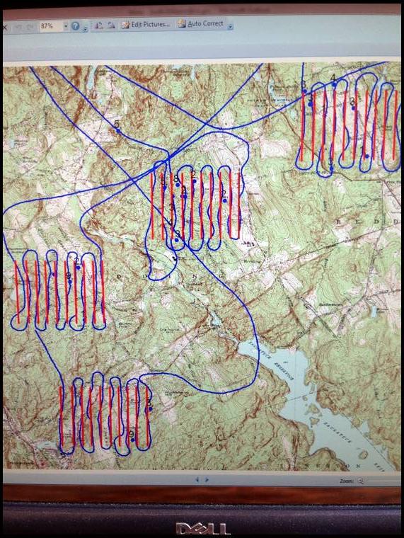

The snake path makes a lot of sense. Thanks for clearing that up for me.
Quotes are fantastic and I'm glad and relieved to see such proficiency from you. Not having to concern myself with misrepresentations or manufactured quotes going forward allows the discussion to focus on the deer; much more conducive to fruitful outcomes.
Speaking of which, interesting point you bring up (and one you omit-more on that in a bit) in your description of the rationale behind the selection of test areas.
Whether we're speaking of sharpshooting or just bowhunting in an urban setting it should go without saying that safety needs take precedence. On this point we're in complete agreement.
Now to the point behind their selection you omitted (due to the dilemna it creates-more on that in a bit).
If the goal of your study was to demonstrate that in a non-insular setting a correlation exists between a reduction in deer numbers and a reduction in lyme incidence it should also go without saying that test areas that offer the required safety component will also be selected based upon holding adequate concentrations of deer.
After all you can't demonstrate any reduction absent good quantity at your starting point, can you? Equally obvious an especially safe test area with very low numbers of deer wouldn't work for your study goal either, would it?
Now the dilemna that poses; stating the obvious reality that the test areas needed to hold good concentrations of deer only lends weight to my point that a reduction in areas of concentration, regardless of those areas % of the town's total area will in fact translate into a quantifiable impact to the town. It is an unavoidable math-based fact.
No spin required, facts do quite well.
OK. Where are we now? Let’s see. Now we are talking about establishment of the study areas that took place 4 years ago back in 2012. We are beyond wintering areas, and have confirmed that the 4 study areas have a cul de sac nature in common. Ok. Gotcha. On to safety. Yes, we both agree that in managing deer or recreationally hunting we don’t want to kill any people. Yes. Agreed.
The goal of the study: “. . . was to demonstrate that in a non-insular setting a correlation exists between a reduction in deer numbers and a reduction in lyme [sic] incidence. . .” Gonna stop you there. The goal of the study, for both CDC and Dr. Stafford, the Principle Investigator on the project, was to find the best treatment combination to reduce ticks and tick-borne disease risk in a residential setting. An offshoot of that main goal for me, a certified wildlife biologist, yes, was to determine if we could reduce deer low enough to reduce ticks in a non-insular residential area and publish the results. I think I have made that point many times over the years.
And now I am kind of lost in your reasoning. Safety yes of course, but sites were selected based on road configuration and we found safe shooting areas within there. “Adequate concentrations of deer” you say? Research shows that hunting can only get deer to 40/square mile in residential areas so we knew there were plenty of them around as shown when WB removed 51 in year one on 2 square miles after the hunting season. We didn’t seek “adequate concentrations of deer”; we know they are there as long as we are in a wooded residential setting. Glad we cleared that up. . .
“After all you can't demonstrate any reduction absent good quantity at your starting point, can you?” Is this English? Not sure what you mean.
“Equally obvious an especially safe test area with very low numbers of deer wouldn't work for your study goal either, would it?” Pretty much nowhere in forested portions of CT are deer at densities we were seeking for this study, especially within Fairfield County. We did not care what initial densities were, we knew them to be well over goal, we just wanted to achieve around 10/sm. Hell if the WB guys had had any say would probably have looked for areas of low density so they wouldn’t have to deal with as many carcasses.
“Now the dilemna [sic] that poses; stating the obvious reality that the test areas needed to hold good concentrations of deer only lends weight to my point that a reduction in areas of concentration, regardless of those areas % of the town's total area will in fact translate into a quantifiable impact to the town.” Huh? What does this even mean?? Dude, this is a really lame attempt to try to say that reducing deer on 2 square miles had some town-wide effect. Eat dinner, take a deep breath, and please come back with something other than nonsensical drivel.
The best advice I received ahead of my Ph. D. dissertation defense was don’t BS if you don’t know the answer, it just makes you look silly.
Thank you from the bottom of my heart for proving I made clear and concise points regarding the need for deer concentrations present in the study areas.
Equal thanks for validating my point about that omission owing more to your reluctance to admit that a reduction in areas with concentrations of deer would have to be felt in the town as it is the % of the herd that is of primary importance and the % of land can be relatively meaningless.
C'mon Scott; really; what both of us know is whenever you feign incomprehension my points have hit the bullseye. Whenever you patronize you recognize those posts highlighting your shortcomings.
Eat dinner? No thanks, I find I'm often far too full after completely eating your lunch.
Do try harder next time will you?
This is just nonsense. 48 deer were taken from Pheasant Ridge over 3 years. There were 30+ deer remaining in that square mile validated by 2 different aerial survey techniques in 2015. If there were that many remaining where the reductions actually took place, how could that have had more of an impact elsewhere in town? Logic man. I'm seeking logic not BS. What you are offering is BS. You couldn't hit a bull's eye at 2 yards.
That`s an easy question; just compare the two cameras and the picture quality/results they provide. Military jets flying up to Mach 3 while filming, capture images with amazing clarity. Davis fly's 325` transects and Vision Air fly's 800` transects which are 2.5X and uses a much higher grade of camera.
Maybe the CAES can explain to us why if they surveyed 6.58 square miles it took less than 3 hours or approximately 27 minutes per square mile ? Did they only survey 1/2 of what they said they did ? The survey report states, the Davis IR survey started at 2020 ( 1/15/2015 ) and ended an 315 ( 1/16/15 ), just under 7 hours; but the Davis IR survey took less than 3 hours to complete 2020:11-2314:50 according to the ( 4 ) films and time stamps.
The CAES has been asked several times to provide the GPS film coordinates and film time stamps for the deer filmed by Davis Aviation ( 1/15/15 ); in both the Pheasant Ridge and White Birch one square mile test areas; to date we have not received any response. This should be very easy because they have already plotted /mapped the deer locations on their initial 1/16/15 report made to the CT DEEP. We have now requested the information through the FOIA.
But thank you for this clarification. So for every one transect Vision Air flies (800' wide), it takes Davis Aviation (325' wide) 2.5 transects to cover the same width. Correct? So Davis flies one square mile in a half hour and Vision Air flies it in 4 minutes? Correct? So you are saying that Vision Air has better detection because they fly wider transects? Ummmm, seems by your own admission and calculations that Davis is actually looking for deer when Vision Air blows over the top of them.
I still do not know what you seek via FOIA, but I will deal with it in the office tomorrow.


Those words are not mine............ Vision Air has better detection due to better camera`s,( two cameras, one wide one narrow view ); not only does she find the target but she is able to zoom in with narrow view to verify / identify the target.
The FOIA request is asking for the GPS / coordinates and time stamps for each target or deer located in the Pheasant Ridge and White birch test sites. I have included a frame from the Davis IR flight ( 1/15/15 ) that you posted on bowsite last year. For every deer or group of deer you mapped / plotted on your report to the CT DEEP simply provide us with the GPS & Time Stamps, which in this frame are - Time 2033:05 / Location - 4120.170N, 07321.466W and shows 8 targets.
Actually we have all the (10) shape files, GPS coordinates and maps from the Vision Air Research`s FLIR surveys for both Redding and Newtown; the data gives us the exact position of every target or deer they filmed...........Please be sure to comply with the FOIA request.
The Davis IR survey films have been sent out to several different companies for review. Initial results from the White Birch test area were 11-12 targets; the initial results from Pheasant Ridge are under 10 targets in the one square mile test area. We will post all of the results as soon as we receive the reports.
I'd love to see an unbiased 3rd party review the WB data to see what they say about all this.

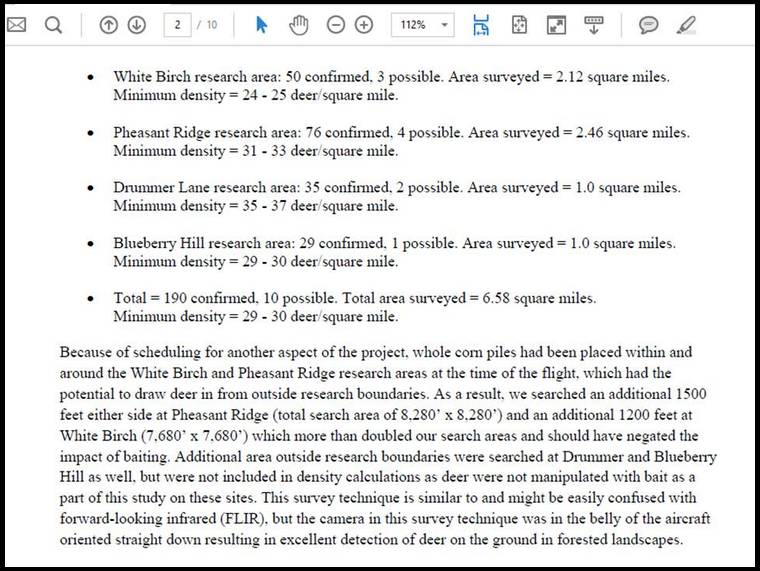
White Birch Test Area - 50 Confirmed (deer) + 3 Possible in an expanded 2.12 Square Mile Area, This indicates a Minimum Density of 23.58 - 25 (deer) per square mile. _________________________________________________________________________________________________
The following data is the result of several Private Company reviews of the Davis Aviation IR Survey Film - Results - 2/9/16
White Birch Test Area - 11 Confirmed (heat signatures) + 2 Possible in the expanded 2.12 Square Mile Area, Minimum Density = 5.18 - 6.13 (heat signatures) per square mile.
Time Stamp Coordinates (heat signatures) for IR Survey - White Birch Disk #1, Film # 2 ( 2111:03 - 2153:35 )
1 - 2111:31 - ( 1 ) Target
2 - 2129:20 - ( 1 ) Target
3 - 2134:07 - ( 1 ) Target
4 - 2134:24 - ( 1 ) Target
5 - 2138:35 - ( 1 ) Target - Outside one square mile test area
6 - 2142:04 - ( 1 ) Target
7 - 2144:47 - ( 1 ) Target - Outside one square mile test area
8 - 2144:58 - ( 1 ) Target - Outside one square mile test area, duplicate of # 5 earlier on film
9 - 2149:11 - ( 3 ) Target
10 - 2151:08 - ( 3 ) Target - Duplicate of # 9 earlier on film
11 - 2151:21 - ( 1 ) Target
The White Birch count of Davis Aviation is 388% higher than the consensus count of multiple independent reviewers. These reviews showed only 9 confirmed heat signatures within the original one square mile test area.
your independent private companies failed to consider the scientific math where you multiply the deer based upon the amount of money your good friend would paid for each deer counted. The scientific term is the "DeNicola Effect".
It works like this: You start with the answer, and then you do the FLIR to document the heat signatures for each deer actually found in the area, then divide the heat signatures into the number of deer required to shoot and obtain more money, then multiply that result by the deer actually counted.
I'm really disappointed you didn't know this, but we're just simple redneck hunters with boots on the ground and no Phd (well, some of us have a Phd) to wave around to ward off logical explanations. :)
Seriously - the answer will be - the CAES vendor already excluded all other FLIR firms as incompetent, so no one else in the entire world is qualified to count deer on the film other than Davis. Why? Because Davis said so.
Phd math not required for the 2nd question either, just good morals and ethics need be applied. How do you justify substantiating the deer density INSIDE the survey area by substantiating the deer density OUTSIDE the survey area? Answer - When it allows your friend Tony to conduct the shoot to get more money and keep a worthless study going, until someone video tapes what's really going on, then you stop. Hmmmm, why stop? Oh yeah, safety. I guess someone who was video taping could have gotten shot by the professional sharpshooter who are trained to know the difference between a deer and man holding a camera. Sounds right.


I was really hoping you would admit that your good friend Tony would have gotten paid whether he went out another time or not, or whether he killed any deer or none. You almost let it slip, but you didn't take the bait, gotta give you that. Must be nice to have friends working for the state to hand over money, no questions asked,....well, except for this site and the FOI requests by Glen and Mike.


Mike in CT's Link
You remember this one right Bob? The one where the cmpany from NC and FL was dropped from consideration as they refer some deer survey work to Davis (though it's mentioned they do some themselves) and Vision Air was just plain dumped on.
Glen got this letter as part of a FOIA package; here are links to a couple of companies not discussed in the letter:
http://aerialthermalimaging.com/
Aerial Thermal Imaging has been in business for years and is based out of Salt Lake City, UT. Kind of far away so maybe that's why they weren't mentioned.
OK, onto the next company:
http://www.resourcemappinggis.com/app_aerial.html
Resource Mapping has been in business for 30 years and is based in MA; I think that's fairly close to CT but I'm sure there's a perfectly valid reason they weren't mentioned.
The most curious omission is the company in the link at the top of my post. Above All - Ohio is based in Ohio (like Davis) and started in 1993 (right about the same time as Davis if I recall correctly).
I don't know about you Bob, but I'd love to hear why their name wasn't mentioned, especially considering a no-bid, sole-source contract was awarded for the Redding IR survey.


Pheasant Ridge Test Area - 47 Confirmed (deer) + 4 Possible in one square mile, This indicates a Minimum Density of 47 - 51 (deer) per square mile.
_________________________________________________________________________________________________
The following data is the result of several Private Company reviews of the Davis Aviation IR Survey Film - Results - 2/9/16
Pheasant Ridge Test Area - 9 Confirmed (heat signatures) + 1 Possible in the one square mile test area. Minimum Density = 9 - 10 (heat signatures) per square mile.
Time Stamp Coordinates for IR Survey - PR (Test Area) Disk #1, Film #1 ( 2020:11 - 2111:03 )
1 - 2023:37 - ( 1 ) Target
2 - 2023:55 - ( 1 ) Target
7 - 2038:13 - ( 1 ) Target
8 - 2039:48 - ( 1 ) Target
12 - 2048:32 - ( 1 ) Target
15 - 2057:42 - ( 3 ) Target
16 - 2059:09 - ( 1 ) Target
The Pheasant Ridge count of Davis Aviation is 422% higher than the consensus count of multiple independent reviewers. These reviews showed only 9 confirmed heat signatures within the original one square mile test area.


Part 2 to follow in next post.


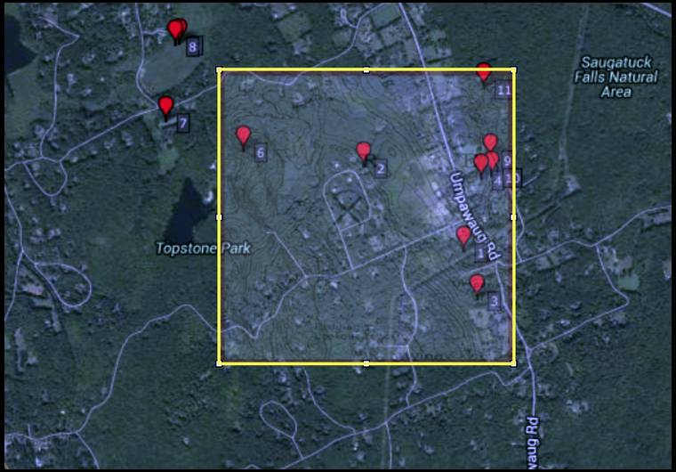
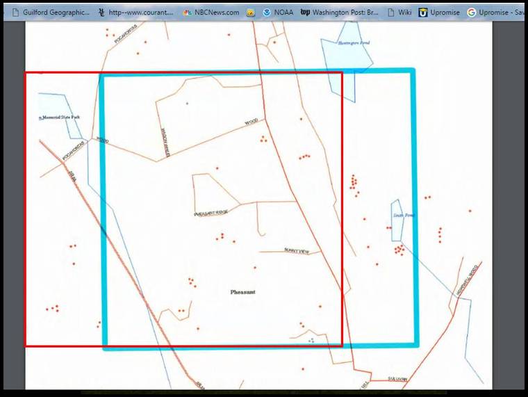
Without a doubt; how good is that submission though if the map itself is inaccurate?
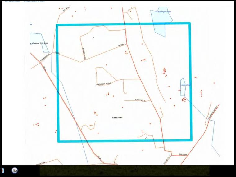
Now here is the actual map. I like how you shifted the target area to the west to exclude all those deer in HSP. Look at the northeast corner of your target area location compared to the actual in reference to Lake Hopewell/Huntington Pond.
No, the actual map is the attached picture above which can be found on page 29 of your revised proposal submitted to the CT DEEP on Jan 10, 2013. That actual map is identical to Glen's. The map that was shifted was shifted to the east and it's the one you attached from the Davis survey.
Give us a break. I'm going to guess that DEEP will figure that out pretty quick.
Yes, by all means please give us a break and dispense with the pretense that it is Glen who's manipulating the maps. I don't need to "guess"; I'm quite sure that the DEEP and anyone else reading this can conclude that the map Glen posted is exactly the same as the map you submitted to the CT DEEP in your revised proposal.
Pictures don't lie Scott; you might want to pay attention to your own work next time.


The reviews of the Davis IR survey films appear to show the deer counts (heat signatures) where manipulated by + 400% on average for both test sites in year three of the CDC ITM study. As a result of the suspected misrepresentation by Davis and the CAES, the CDC was billed an additional $29,306.06 for White Buffalo’s services.
it's the shell game, remember? Watch the moving survey lines, which lines outline the area, watch me as I move the square around the map, around and around it goes, where it stops nobody knows, not even the deer or the CAES, but who cares, it's over now, the money's been spent, friend got his money, and the hunters are too dumb to figure out where the survey area is, was, should be. Double talk, triple talk, half truths, omissions, both sides of your mouth, talking out of your a _ _, all of the above.
I'd like to thank everyone for making this post deer season period entertaining, it's been fun.
Hi Glen,
I just went through and confirmed the targets you had identified for the White Birch and Pheasant areas. I saw the targets you referred to, but from the imagery presented, I was unable to identify any of the targets as either being or not being deer. This imagery is able to show hot spots which could include deer, but there is insufficient resolution to confirm. Also, it was taken at a high airspeed, further limiting the potential for a positive ID. I am sorry, but we will not be able to generate an estimate of deer density from this imagery.
_______________________________________________
Hi Glen:
I've had a chance to review the two thermal videos you sent and these are my impressions:
The image quality is very course due to the dated technology used for these flights and as a result, in my opinion...it is not possible to obtain an accurate deer count from this data. The thermal emission sources seen in these videos are excessively blocky and as a result it is not possible to accurately identify the targets which emit the heat. Whomever identified and counted deer from this data was either a clairvoyant or a fraud.
Over my career I have both done and peer-reviewed hundreds of ungulate surveys using thermal imaging. From a technology and research design perspective, this is one of the worst I've ever encountered.
______________________________________________
The Davis Aviation IR film could reasonably be seen as an nothing other than an attempt to secure federal funds by deception; certainly it appears that the deer numbers were greatly exaggerated over the actual filmed and on-the-ground reality at an expense to the taxpayers of $29,306.06.
Having received these professional reviews (and with more to come) it is now crystal clear to me why Scott Williams continues to post one misrepresentation after another; this is man who knows he has been caught in a lie and that the game is over, plain and simple. Like any pathological liar the saddest part is he probably believes a good portion of what he says; and equally sad is that he is incapable of admitting that he's lied, even when it's so painfully obvious to everyone reading these threads.
Dr. Williams - " What's the ultimate recourse? "...............My guess would be 1-5.


We must keep in mind that this is normal operating procedure at the state level. airrow pointed to former Gov Roland as just one example, so we have a warped perception of what's acceptable and what's not at the state level I guess.

